File:Smålenenes amt nr 110- Kart over Egnen øst og nord Fredriksstad, 1800.jpg
Jump to navigation
Jump to search
Size of this preview: 412 × 599 pixels. Other resolutions: 165 × 240 pixels | 330 × 480 pixels | 528 × 768 pixels | 704 × 1,024 pixels | 1,407 × 2,048 pixels | 4,406 × 6,411 pixels.
Original file (4,406 × 6,411 pixels, file size: 5.7 MB, MIME type: image/jpeg)
Captions
Captions
Add a one-line explanation of what this file represents
Summary
[edit]
| Title |
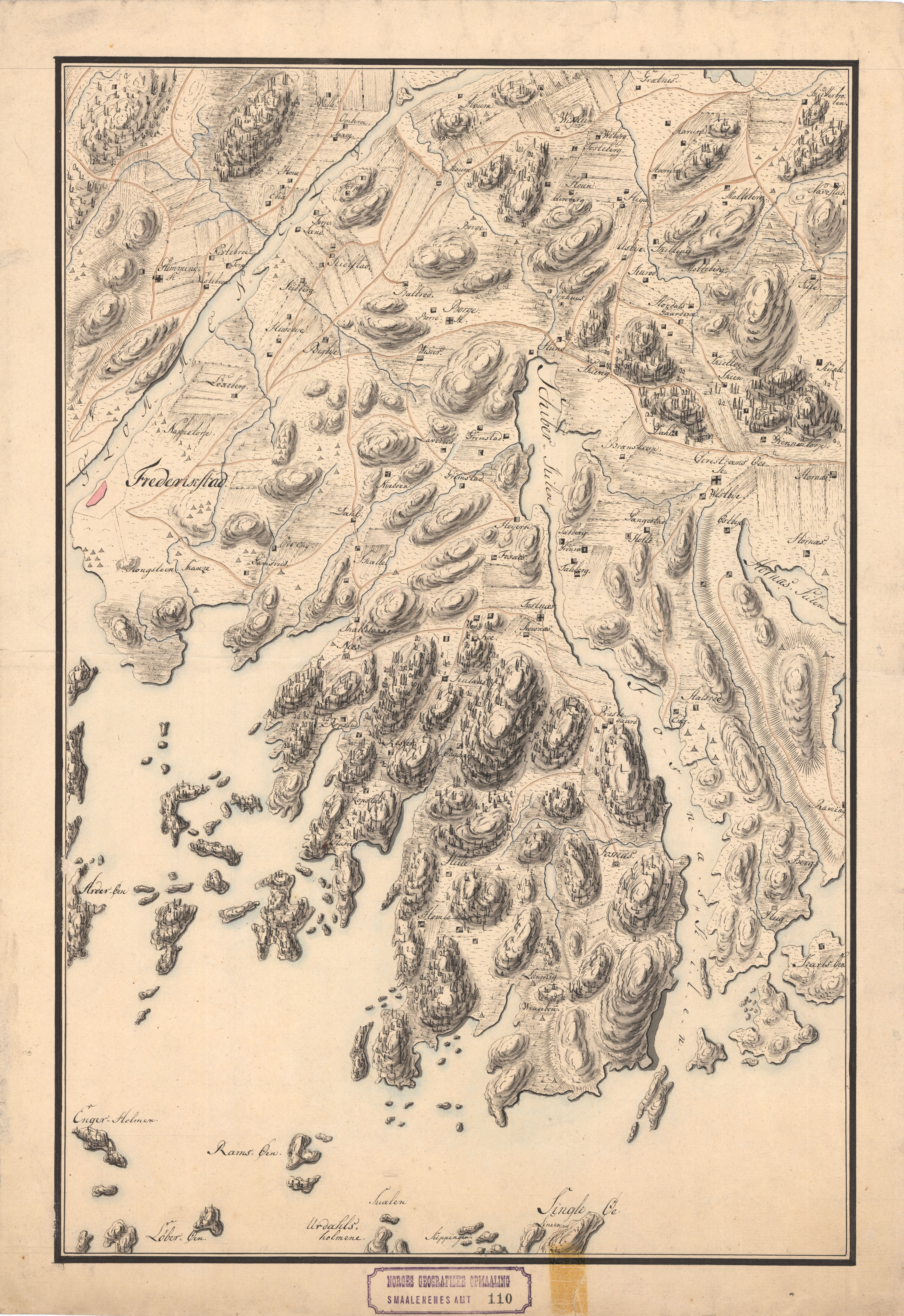
Norsk bokmål: Smålenenes amt nr 110: Kart over Egnen øst og nord Fredriksstad, 1800 |
||||||||||||||||||||||||||
| Description |
Norsk bokmål: Årstall usikkert |
||||||||||||||||||||||||||
| Date | |||||||||||||||||||||||||||
| Source |
|
||||||||||||||||||||||||||
| Permission (Reusing this file) |
This file is licensed under the Creative Commons Attribution 4.0 International license.
|
||||||||||||||||||||||||||
| Geotemporal data | |||||||||||||||||||||||||||
| Date depicted | |||||||||||||||||||||||||||
| Map location | Østfold (Østfold) | ||||||||||||||||||||||||||
| Scale | 1:34,000 | ||||||||||||||||||||||||||
| Georeferencing | If inappropriate please set warp_status = skip to hide. | ||||||||||||||||||||||||||
| Bibliographic data | |||||||||||||||||||||||||||
| Part of the series | Category:Smålenenes county | ||||||||||||||||||||||||||
| Map sheet | 110 | ||||||||||||||||||||||||||
| Language | Norwegian | ||||||||||||||||||||||||||
| Archival data | |||||||||||||||||||||||||||
| Collection |
|
||||||||||||||||||||||||||
| Accession number | |||||||||||||||||||||||||||
| Medium | drawing | ||||||||||||||||||||||||||
File history
Click on a date/time to view the file as it appeared at that time.
| Date/Time | Thumbnail | Dimensions | User | Comment | |
|---|---|---|---|---|---|
| current | 15:44, 31 October 2015 | | 4,406 × 6,411 (5.7 MB) | Artturimatias (talk | contribs) | GWToolset: Creating mediafile for Artturimatias. |
You cannot overwrite this file.
File usage on Commons
There are no pages that use this file.