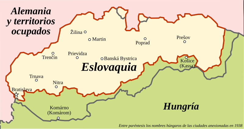
File:Slovakia1941 02 ES.svg
From Wikimedia Commons, the free media repository
Jump to navigation
Jump to search

Size of this PNG preview of this SVG file: 800 × 422 pixels. Other resolutions: 320 × 169 pixels | 640 × 338 pixels | 1,024 × 540 pixels | 1,280 × 676 pixels | 2,560 × 1,351 pixels | 972 × 513 pixels.
Original file (SVG file, nominally 972 × 513 pixels, file size: 196 KB)
File information
Structured data
Captions
Captions
Add a one-line explanation of what this file represents
Summary
[edit]| DescriptionSlovakia1941 02 ES.svg |
Español: Mapa de la República de Eslovaquia (1939-1945) durante la Segunda Guerra Mundial, con la frontera actual:
Frontera (1940) Frontera (2010) Otras fronteras English: Map of the Slovak Republic (1939-1945) during WWII along with present borders. |
|||
| Date | ||||
| Source | Slovakia1941 02.png | |||
| Author |
|
|||
| Permission (Reusing this file) |
|
|||
| Other versions |
[edit]
|
|||
| SVG development InfoField |
|
Original upload log
[edit]This image is a derivative work of the following images:
- Slovakia1941 02.png licensed with PD-self
- 2009-08-22T17:04:49Z PANONIAN 997x753 (51567 Bytes)
- 2009-08-22T14:02:47Z PANONIAN 997x662 (46648 Bytes)
- 2006-12-28T16:25:45Z Electionworld 773x448 (7833 Bytes) {{ew|en|PANONIAN}} historic map of Slovakia (self made) {{PD-self}} [[Category:Maps of the history of Slovakia]] [[Category:Maps of World War II in Europe 1941]]
Uploaded with derivativeFX
File history
Click on a date/time to view the file as it appeared at that time.
| Date/Time | Thumbnail | Dimensions | User | Comment | |
|---|---|---|---|---|---|
| current | 10:06, 10 July 2021 |  | 972 × 513 (196 KB) | Rowanwindwhistler (talk | contribs) | Simplified and minor changes in borders and colours. |
| 08:52, 28 October 2017 |  | 997 × 753 (422 KB) | Rowanwindwhistler (talk | contribs) | Lighter colours (text made easier to read) | |
| 10:50, 13 September 2016 |  | 997 × 753 (425 KB) | Rowanwindwhistler (talk | contribs) | Fake text layer added, real text hidden. Larger fonts | |
| 11:09, 24 September 2014 |  | 997 × 753 (51 KB) | Rowanwindwhistler (talk | contribs) | New layers, new colors, slight changes | |
| 08:47, 21 April 2010 |  | 997 × 753 (44 KB) | Rowanwindwhistler (talk | contribs) | Error spotted by user User:PANONIAN corrected | |
| 08:35, 2 January 2010 |  | 997 × 753 (44 KB) | Rowanwindwhistler (talk | contribs) | {{Information |Description={{es|1=Mapa de la República de Eslovaquia (1939-1945) durante la Segunda Guerra Mundial, con la frontera actual.}} {{en|1=Map of the Slovak Republic (1939-1945) during WWII along with present borders.}} |Source=*[[:File:Slovaki |
You cannot overwrite this file.
File usage on Commons
The following 9 pages use this file:
- User:Magog the Ogre/Maps of conflicts/2016 September
- User:Magog the Ogre/Maps of conflicts/2017 October
- User:Magog the Ogre/Maps of conflicts/2021 July
- User:Magog the Ogre/Multilingual legend/2021 July 1-10
- File:Slovakia1941 02.png
- File:Slovakia1941 02 (it).png
- File:Slovakia1941 02 ES.svg
- File:Slovakia 1941 ru.svg
- Template:Other versions/Slovakia1941 02
File usage on other wikis
The following other wikis use this file:
- Usage on ast.wikipedia.org
- Usage on ca.wikipedia.org
- Usage on es.wikipedia.org
- Usage on gl.wikipedia.org
- Usage on pt.wikipedia.org
Metadata
This file contains additional information such as Exif metadata which may have been added by the digital camera, scanner, or software program used to create or digitize it. If the file has been modified from its original state, some details such as the timestamp may not fully reflect those of the original file. The timestamp is only as accurate as the clock in the camera, and it may be completely wrong.
| Width | 972.0434 |
|---|---|
| Height | 513.35675 |


