File:Sled dogs on sea ice in North Star Bay near Thule Air Base, Greenland.jpg
From Wikimedia Commons, the free media repository
Jump to navigation
Jump to search
![File:Sled dogs on sea ice in North Star Bay near Thule Air Base, Greenland.jpg](https://upload.wikimedia.org/wikipedia/commons/thumb/f/fe/Sled_dogs_on_sea_ice_in_North_Star_Bay_near_Thule_Air_Base%2C_Greenland.jpg/800px-Sled_dogs_on_sea_ice_in_North_Star_Bay_near_Thule_Air_Base%2C_Greenland.jpg?20130410102054)
Size of this preview: 800 × 140 pixels. Other resolutions: 320 × 56 pixels | 640 × 112 pixels | 3,200 × 560 pixels.
Original file (3,200 × 560 pixels, file size: 480 KB, MIME type: image/jpeg)
File information
Structured data
Captions
Captions
Add a one-line explanation of what this file represents
Summary
[edit]DescriptionSled dogs on sea ice in North Star Bay near Thule Air Base, Greenland.jpg |
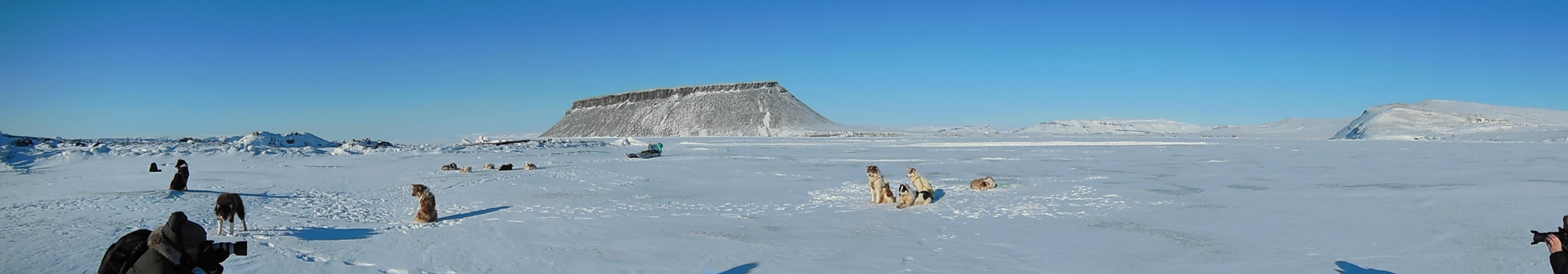
English: Sled dogs on sea ice in North Star Bay near Thule Air Base, Greenland, with 700-foot-high Mount Dundas in the background. With no road or rail network between them, cities in Greenland are primarily connected by ship and aircraft. For shorter distances, people often use snowmobiles or dogsleds as a way to travel and transport goods. Dogsled races on North Star Bay were a highlight of Armed Forces day activities at Thule on Mar. 30, 2013. |
Date | |
Source | http://www.nasa.gov/mission_pages/icebridge/news/spr13/index.html |
Author | NASA / Christy Hansen |
Licensing
[edit]Public domainPublic domainfalsefalse |
![]() |
This file is in the public domain in the United States because it was solely created by NASA. NASA copyright policy states that "NASA material is not protected by copyright unless noted". (See Template:PD-USGov, NASA copyright policy page or JPL Image Use Policy.) | ![]() |
![]() |
Warnings:
|
File history
Click on a date/time to view the file as it appeared at that time.
Date/Time | Thumbnail | Dimensions | User | Comment | |
---|---|---|---|---|---|
current | 10:20, 10 April 2013 | ![]() | 3,200 × 560 (480 KB) | Stas1995 (talk | contribs) | User created page with UploadWizard |
You cannot overwrite this file.
File usage on Commons
There are no pages that use this file.
Metadata
This file contains additional information such as Exif metadata which may have been added by the digital camera, scanner, or software program used to create or digitize it. If the file has been modified from its original state, some details such as the timestamp may not fully reflect those of the original file. The timestamp is only as accurate as the clock in the camera, and it may be completely wrong.
Camera manufacturer | NIKON |
---|---|
Camera model | COOLPIX S9300 |
Exposure time | 1/2,500 sec (0.0004) |
F-number | f/7.4 |
ISO speed rating | 125 |
Date and time of data generation | 13:51, 29 March 2013 |
Lens focal length | 5.2 mm |
Orientation | Normal |
Horizontal resolution | 300 dpi |
Vertical resolution | 300 dpi |
Software used | COOLPIX S9300V1.1 |
File change date and time | 13:51, 29 March 2013 |
Y and C positioning | Co-sited |
Exposure Program | Normal program |
Exif version | 2.3 |
Date and time of digitizing | 13:51, 29 March 2013 |
Meaning of each component |
|
Image compression mode | 2 |
APEX exposure bias | 0 |
Maximum land aperture | 3.6 APEX (f/3.48) |
Metering mode | Pattern |
Light source | Unknown |
Flash | Flash did not fire, compulsory flash suppression |
Supported Flashpix version | 1 |
Color space | sRGB |
File source | Digital still camera |
Scene type | A directly photographed image |
Custom image processing | Normal process |
Exposure mode | Auto exposure |
White balance | Auto white balance |
Digital zoom ratio | 0 |
Focal length in 35 mm film | 29 mm |
Scene capture type | Standard |
Scene control | None |
Subject distance range | Unknown |
Reference for direction of image | Magnetic direction |
Direction of image | 128 |
Geodetic survey data used | WGS-84 |
GPS tag version | 84.15.05.84 |