File:Slavonia.svg

Original file (SVG file, nominally 1,098 × 1,063 pixels, file size: 798 KB)
Captions
Captions
Summary
[edit]| DescriptionSlavonia.svg |
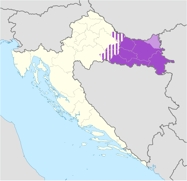
English: Location map of Croatia with area of Slavonia highlighted in purple, areas variously associated with Slavonia and Central Croatia in striped purple and Croatian Baranja/Baranya in light purple |
| Date | |
| Source | Own work using file:Croatia location map.svg by NordNordWest |
| Author | Tomobe03 |
Equirectangular projection, N/S stretching 140 %. Geographic limits of the map:
N: 46.8° N S: 42.1° N W: 13.1° E E: 19.9° E
Licensing
[edit]- You are free:
- to share – to copy, distribute and transmit the work
- to remix – to adapt the work
- Under the following conditions:
- attribution – You must give appropriate credit, provide a link to the license, and indicate if changes were made. You may do so in any reasonable manner, but not in any way that suggests the licensor endorses you or your use.
- share alike – If you remix, transform, or build upon the material, you must distribute your contributions under the same or compatible license as the original.
File history
Click on a date/time to view the file as it appeared at that time.
| Date/Time | Thumbnail | Dimensions | User | Comment | |
|---|---|---|---|---|---|
| current | 10:17, 19 July 2020 |  | 1,098 × 1,063 (798 KB) | Koreanovsky (talk | contribs) | When we talk about modern-day Slavonia, we usually refer to the region that is colored in dark purple. There is no exact definition, since those regions are historical and do not have any official status, but mostly we do not include those parts that are striped, such as in the region of small Moslavina. |
| 18:28, 7 June 2014 |  | 1,098 × 1,063 (751 KB) | DIREKTOR (talk | contribs) | Fixed borders, removed a number of issues. | |
| 10:49, 7 June 2014 |  | 1,098 × 1,063 (798 KB) | DIREKTOR (talk | contribs) | Corrections. | |
| 09:09, 7 June 2014 |  | 1,098 × 1,063 (798 KB) | DIREKTOR (talk | contribs) | Small fix. | |
| 07:30, 7 June 2014 |  | 1,098 × 1,063 (799 KB) | DIREKTOR (talk | contribs) | Small-scale modifications. | |
| 11:58, 6 June 2014 |  | 512 × 496 (268 KB) | DIREKTOR (talk | contribs) | Colours | |
| 11:12, 7 March 2012 |  | 1,098 × 1,063 (440 KB) | Tomobe03 (talk | contribs) |
You cannot overwrite this file.
File usage on Commons
The following 2 pages use this file:
File usage on other wikis
The following other wikis use this file:
- Usage on ar.wikipedia.org
- Usage on bg.wikipedia.org
- Usage on br.wikipedia.org
- Usage on bs.wikipedia.org
- Usage on ca.wikipedia.org
- Usage on de.wikipedia.org
- Usage on de.wikivoyage.org
- Usage on de.wiktionary.org
- Usage on en.wikipedia.org
- Usage on eo.wikipedia.org
- Usage on es.wikipedia.org
- Usage on et.wikipedia.org
- Usage on eu.wikipedia.org
- Usage on fa.wikipedia.org
- Usage on hr.wikipedia.org
- Usage on hu.wikipedia.org
- Usage on it.wikivoyage.org
- Usage on kk.wikipedia.org
- Usage on ko.wikipedia.org
- Usage on la.wikipedia.org
- Usage on li.wikipedia.org
- Usage on lv.wikipedia.org
- Usage on mzn.wikipedia.org
- Usage on pl.wikipedia.org
- Usage on pl.wikivoyage.org
- Usage on ru.wikipedia.org
- Usage on ru.wikivoyage.org
- Usage on sh.wikipedia.org
- Usage on sr.wikipedia.org
- Usage on sv.wikipedia.org
- Usage on uk.wikipedia.org
- Usage on ur.wikipedia.org
- Usage on www.wikidata.org
- Usage on zh.wikipedia.org
Metadata
This file contains additional information such as Exif metadata which may have been added by the digital camera, scanner, or software program used to create or digitize it. If the file has been modified from its original state, some details such as the timestamp may not fully reflect those of the original file. The timestamp is only as accurate as the clock in the camera, and it may be completely wrong.
| Width | 1097.96 |
|---|---|
| Height | 1062.61 |