File:Slaskie mapa fizyczna.png
Jump to navigation
Jump to search

Size of this preview: 439 × 599 pixels. Other resolutions: 176 × 240 pixels | 351 × 480 pixels | 562 × 768 pixels | 750 × 1,024 pixels | 1,635 × 2,232 pixels.
Original file (1,635 × 2,232 pixels, file size: 415 KB, MIME type: image/png)
Captions
Captions
Add a one-line explanation of what this file represents
Summary
[edit]
| Description |
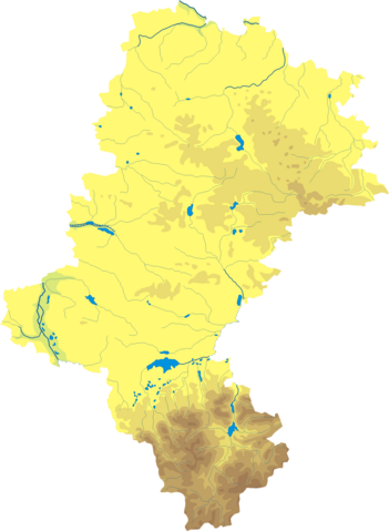
Polski: Mapa wód i ukształtowania powierzchni województwa śląskiego. Autor: Aotearoa Współrzędne graniczne mapy:
Legenda:  |
| Date | 29 August 2006 (original upload date) |
| Source | Transferred from pl.wikipedia to Commons by Pjahr using CommonsHelper. |
| Author | Aotearoa at Polish Wikipedia |
Licensing
[edit]
Aotearoa at Polish Wikipedia, the copyright holder of this work, hereby publishes it under the following license:

|
Permission is granted to copy, distribute and/or modify this document under the terms of the GNU Free Documentation License, Version 1.2 or any later version published by the Free Software Foundation; with no Invariant Sections, no Front-Cover Texts, and no Back-Cover Texts. A copy of the license is included in the section entitled GNU Free Documentation License. |
| This file is licensed under the Creative Commons Attribution-Share Alike 3.0 Unported license. | ||
| Attribution: Aotearoa at Polish Wikipedia | ||
| ||
| This licensing tag was added to this file as part of the GFDL licensing update. |
Original upload log
[edit]
The original description page was here. All following user names refer to pl.wikipedia.
- 2006-08-29 18:32 Aotearoa 347×462× (53485 bytes) Mapa wód i ukształtowania powierzchni województwa śląskiego. Autor: [[Wikipedysta:Aotearoa|Aotearoa]]
File history
Click on a date/time to view the file as it appeared at that time.
| Date/Time | Thumbnail | Dimensions | User | Comment | |
|---|---|---|---|---|---|
| current | 10:58, 29 October 2012 | | 1,635 × 2,232 (415 KB) | Aotearoa (talk | contribs) | drobne techniczne |
| 21:36, 6 December 2009 |  | 347 × 462 (52 KB) | File Upload Bot (Magnus Manske) (talk | contribs) | {{BotMoveToCommons|pl.wikipedia|year={{subst:CURRENTYEAR}}|month={{subst:CURRENTMONTHNAME}}|day={{subst:CURRENTDAY}}}} {{Information |Description={{pl|Mapa wód i ukształtowania powierzchni województwa śląskiego. Autor: [[:pl:Wikipedysta:Aotearoa|Aot |
You cannot overwrite this file.
File usage on Commons
The following page uses this file:
- File:Województwo śląskie - mapa fizyczna.png (file redirect)
File usage on other wikis
The following other wikis use this file:
- Usage on be.wikipedia.org
- Usage on bg.wikipedia.org
- Ченстохова
- Катовице
- Сосновец
- Швентохловице
- Горносилезка метрополия
- Явожно
- Гливице
- Битом
- Забже
- Рибник (град)
- Силезко войводство
- Белско-Бяла
- Хожов
- Руда Шльонска
- Тихи
- Домброва Гурнича
- Мисловице
- Шемяновице Шльонске
- Пекари Шльонске
- Жори
- Ястшембе-Здруй
- Рачибуж
- Тарновске Гури
- Бенджин
- Заверче
- Воджислав Шльонски
- Славков (Силезко войводство)
- Чешин
- Люблинец
- Миколов
- Мишков
- Пшчина
- Живец
- Чеховице-Джеджице
- Челядж
- Червьонка-Лешчини
- Кнуров
- Лажиска Гурне
- Ридултови
- Берун
- Клобуцк
- Писковице
- Ожеше
- Радлин
- Раджьонков
- Ленджини
- Устрон
- Скочов
- Шаблон:ПК Полша Силезко войводство
View more global usage of this file.