File:Skuteč, CZ161211-036.jpg
Jump to navigation
Jump to search
Size of this preview: 800 × 449 pixels. Other resolutions: 320 × 179 pixels | 640 × 359 pixels | 1,024 × 574 pixels | 1,280 × 718 pixels | 2,560 × 1,435 pixels | 4,552 × 2,552 pixels.
Original file (4,552 × 2,552 pixels, file size: 2.68 MB, MIME type: image/jpeg)
Captions
Captions
Add a one-line explanation of what this file represents
Summary
[edit]
| Description | |
| Date | |
| Source | Own work |
| Author | Josef Kreuz (PEPan) |
| Camera location | | View this and other nearby images on: OpenStreetMap |
|---|
Faktografie
[edit]
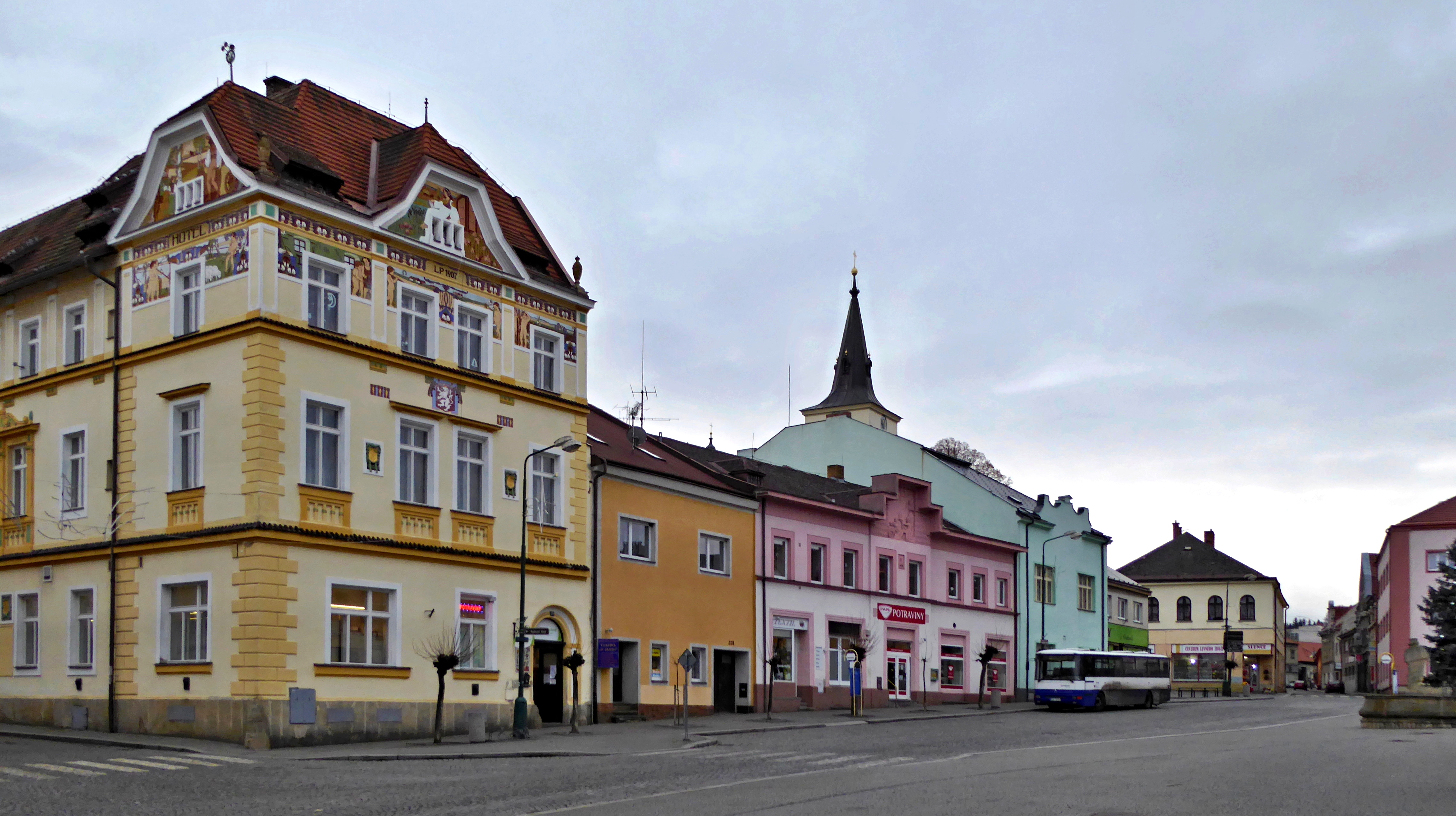
V letech 1866 - 1929 byla Skuteč sídlem samosprávného okresu. Pro kanceláře tehdejšího okresního zastupitelstva byl zrekonstruovaný objekt původního zájezdního hostince „U Zlatého kohouta" na rohu dnes Palackého náměstí a Heydukovy ulice. Pomístně byl nazýván „parlament", v přízemí byla restaurace, ve 2. polovině 20. století pojmenovaná „Sport".[1] Palackého náměstí výstavbou domů s účelovými prostorami v přízemí se v průběhu let stalo přirozeným centrem města s obchody a službami a také zastávkou pro autobusovou dopravu spojující Skuteč s okolními obcemi (Chrast, Luže, Vysoké Mýto, Proseč, Krouna, Prosetín, Hlinsko, Vrbatův Kostelec a dalšími) i vzdálenějšími městy, například okresním (Chrudim) a krajským (Pardubice).[2]
Externí odkazy
[edit]
- 2016-12-15 Palackého náměstí - centrum města (letecká mapa)
Licensing
[edit]
I, the copyright holder of this work, hereby publish it under the following license:
This file is licensed under the Creative Commons Attribution-Share Alike 4.0 International license.
- You are free:
- to share – to copy, distribute and transmit the work
- to remix – to adapt the work
- Under the following conditions:
- attribution – You must give appropriate credit, provide a link to the license, and indicate if changes were made. You may do so in any reasonable manner, but not in any way that suggests the licensor endorses you or your use.
- share alike – If you remix, transform, or build upon the material, you must distribute your contributions under the same or compatible license as the original.
File history
Click on a date/time to view the file as it appeared at that time.
| Date/Time | Thumbnail | Dimensions | User | Comment | |
|---|---|---|---|---|---|
| current | 11:41, 15 December 2016 | | 4,552 × 2,552 (2.68 MB) | PEPan (talk | contribs) | User created page with UploadWizard |
You cannot overwrite this file.
File usage on Commons
There are no pages that use this file.
File usage on other wikis
The following other wikis use this file:
- Usage on cs.wikipedia.org