File:Skępe (gmina) location map.png
Jump to navigation
Jump to search

Size of this preview: 594 × 600 pixels. Other resolutions: 238 × 240 pixels | 475 × 480 pixels | 948 × 957 pixels.
Original file (948 × 957 pixels, file size: 120 KB, MIME type: image/png)
Captions
Captions
Add a one-line explanation of what this file represents
| Description |
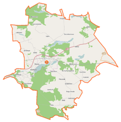
Polski: Mapa gminy Skępe, Polska
English: Map of Gmina Skępe, Poland |
|||||||||
| Date | ||||||||||
| Source | You may find a page on the OpenStreetMap wiki page for Skępe (gmina) | |||||||||
| Creator |
OpenStreetMap contributors OpenStreetMap contributors |
|||||||||
| Permission (Reusing this file) |
OpenStreetMap data is available under the Open Database License (details). Map tiles are licensed under the Creative Commons Attribution-ShareAlike 2.0 license (CC-BY-SA 2.0).
This file is licensed under the Creative Commons Attribution-Share Alike 2.0 Generic license.
|
|||||||||
| Geotemporal data | ||||||||||
| Bounding box |
|
|||||||||
| Georeferencing | If inappropriate please set warp_status = skip to hide. | |||||||||
File history
Click on a date/time to view the file as it appeared at that time.
| Date/Time | Thumbnail | Dimensions | User | Comment | |
|---|---|---|---|---|---|
| current | 07:25, 31 October 2014 | | 948 × 957 (120 KB) | VanWiel (talk | contribs) | {{OpenStreetMap | name = Skępe (gmina) | location = Skępe (gmina) | description = {{pl|Mapa gminy Skępe, Polska}} {{en|Map of Gmina Skępe, Poland}} | top = 52.9561 | left = 19.2360 | right... |
You cannot overwrite this file.
File usage on Commons
There are no pages that use this file.
File usage on other wikis
The following other wikis use this file:
- Usage on fr.wikipedia.org
- Usage on pl.wikipedia.org
- Skępe
- Skępe (gmina)
- Jarczewo
- Likiec
- Lubówiec
- Ławiczek
- Szczekarzewo
- Żagno
- Żuchowo
- Boguchwała (powiat lipnowski)
- Czermno (województwo kujawsko-pomorskie)
- Kukowo (województwo kujawsko-pomorskie)
- Wioska (województwo kujawsko-pomorskie)
- Franciszkowo (powiat lipnowski)
- Huta (powiat lipnowski)
- Łąkie (powiat lipnowski)
- Moczadła (powiat lipnowski)
- Sarnowo (powiat lipnowski)
- Wólka (powiat lipnowski)
- Koziołek (województwo kujawsko-pomorskie)
- Pokrzywnik (województwo kujawsko-pomorskie)
- Obóz (wieś)
- Grabówiec (powiat lipnowski)
- Rumunki Skępskie
- Babie Ławy
- Bógzapłać
- Chałacie
- Czarny Las (województwo kujawsko-pomorskie)
- Gęstowarka
- Głęboczek (gmina Skępe)
- Gorzeszyn
- Guzowatka (województwo kujawsko-pomorskie)
- Józefkowo (powiat lipnowski)
- Kamienica (gmina Skępe)
- Kierz (województwo kujawsko-pomorskie)
- Kujawy (powiat lipnowski)
- Modrzewie (województwo kujawsko-pomorskie)
- Narutowo
- Radziochy
- Zajeziorze (gmina Skępe)
- Rezerwat przyrody Przełom Mieni
- Koziołek (przystanek kolejowy)
- Czermno (przystanek kolejowy)
- Skępe (stacja kolejowa)
- Jezioro Łąkie (gmina Skępe)
- Parafia Miłosierdzia Bożego w Skępem
- Parafia Zwiastowania Najświętszej Maryi Panny w Skępem
- Skępe (stacja wąskotorowa)
View more global usage of this file.
_location_map.png)
_location_map.png&oldid=506624387)