File:Sjøkart over kysten utenfor Finnmark, fra Tanahorn til grensen mot Russland, fra 1847.png
Jump to navigation
Jump to search

Size of this preview: 414 × 600 pixels. Other resolutions: 166 × 240 pixels | 331 × 480 pixels | 530 × 768 pixels | 707 × 1,024 pixels | 1,414 × 2,048 pixels | 2,918 × 4,226 pixels.
Original file (2,918 × 4,226 pixels, file size: 24.32 MB, MIME type: image/png)
Captions
Captions
Add a one-line explanation of what this file represents
Summary
[edit]
| Description |
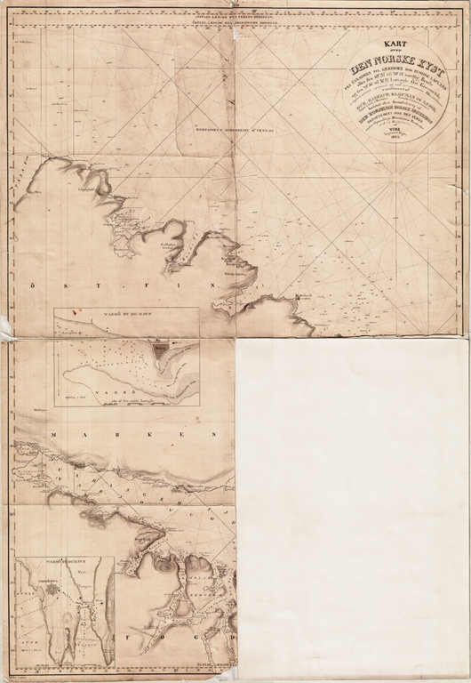
Norsk bokmål: Sjøkart over kysten utenfor Finnmark, fra Tanahorn til grensen mot Russland, fra 1847. Håndtegnet i ukjent målestokk av Vibe. Original kartstørrelse ca 62 x 89 cm. Et eksemplar befinner seg hos Statens kartverk Sjø i Stavanger. |
| Date | |
| Source | Statens kartverk Sjø |
| Author | Vibe |
Licensing
[edit]
|
This work is in the public domain in its country of origin and other countries and areas where the copyright term is the author's life plus 100 years or fewer. | |
| This file has been identified as being free of known restrictions under copyright law, including all related and neighboring rights. | |
File history
Click on a date/time to view the file as it appeared at that time.
| Date/Time | Thumbnail | Dimensions | User | Comment | |
|---|---|---|---|---|---|
| current | 13:00, 1 August 2011 | | 2,918 × 4,226 (24.32 MB) | Kcita (talk | contribs) | {{Information |Description ={{no|1=Sjøkart over kysten utenfor Finnmark, fra Tanahorn til grensen mot Russland, fra 1847. Håndtegnet i ukjent målestokk av Vibe. Original kartstørrelse ca 62 x 89 cm. Et eksemplar befinner seg hos Statens kartverk Sj |
You cannot overwrite this file.
File usage on Commons
There are no pages that use this file.