File:Sixteen Mile Creek bridge, 1922.png
Jump to navigation
Jump to search
Size of this preview: 479 × 600 pixels. Other resolutions: 192 × 240 pixels | 508 × 636 pixels.
Original file (508 × 636 pixels, file size: 311 KB, MIME type: image/png)
Captions
Captions
Add a one-line explanation of what this file represents
Summary
[edit]| Description |
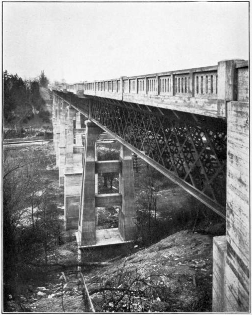
English: The new Sixteen Mile Creek bridge on the Dundas Highway (later w:Ontario Highway 5). Original caption: "Dundas Street Provincial Highway: High level bridge over Sixteen Mile Creek. Length of bridge 936 feet; height of floor above bed of stream 126 feet." |
||||||
| Date | circa 1922 | ||||||
| Source | Annual Report, 1922 | ||||||
| Author | Department of Public Highways of Ontario | ||||||
| Permission (Reusing this file) |
|
||||||

File history
Click on a date/time to view the file as it appeared at that time.
| Date/Time | Thumbnail | Dimensions | User | Comment | |
|---|---|---|---|---|---|
| current | 13:13, 16 April 2022 | | 508 × 636 (311 KB) | Floydian (talk | contribs) | == Summary == {{Information | description = The new Sixteen Mile Creek bridge on the Dundas Highway (later Ontario Highway 5). Original caption: "Dundas Street Provincial Highway: High level bridge over Sixteen Mile Creek. Length of bridge 936 feet; height of floor above bed of stream 126 feet." | source = [https://archive.org/details/n04ontariosession55ontauoft/page/n169/mode/2up?view=theater Annual Report, 1922] | date = circa 1922 | author = Department of P... |
You cannot overwrite this file.
File usage on Commons
The following page uses this file: