File:Situation in Kashmir modh.png
Jump to navigation
Jump to search

Size of this preview: 800 × 585 pixels. Other resolutions: 320 × 234 pixels | 640 × 468 pixels | 1,024 × 749 pixels | 1,280 × 936 pixels | 2,560 × 1,872 pixels | 2,989 × 2,186 pixels.
Original file (2,989 × 2,186 pixels, file size: 11.48 MB, MIME type: image/png)
Captions
Captions
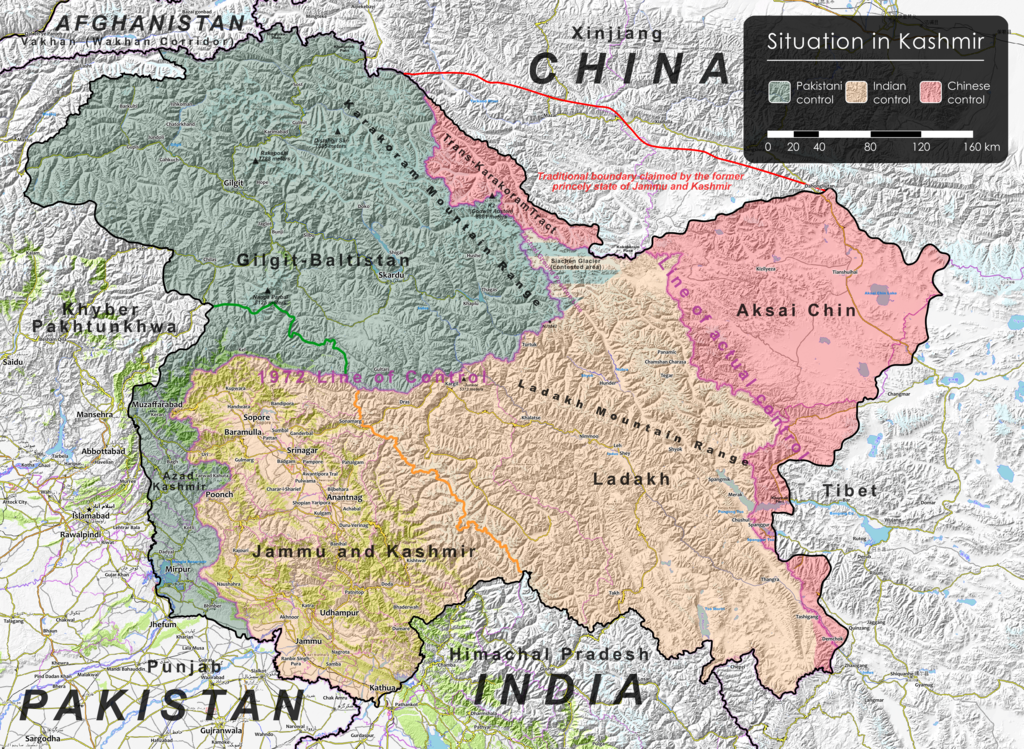
Situation in Kashmir modh
Summary
[edit]| Description | |
| Date | |
| Source | Map of Kashmir region created by the US Central Intelligence Agency, 2004; altered by Viewsridge (talk) 21:20, 5 April 2022 (UTC) |
| Author | US Central Intelligence Agency, Rr016 and Viewsridge |
| Other versions |
|


![[1]](https://www.mediafire.com/file/09o598xq9cjh3fn/Situation+in+Kashmir+mod3.svg/file)
Licensing
[edit]
| This image is a work of a Central Intelligence Agency employee, taken or made as part of that person's official duties. As a Work of the United States Government, this image or media is in the public domain in the United States.
|

|
| Annotations | This image is annotated: View the annotations at Commons |
| Description |
This map was created from OpenStreetMap project data, collected by the community. This map may be incomplete, and may contain errors. Don't rely solely on it for navigation. |
|||
| Date | (see file history) | |||
| Source | openstreetmap.org | |||
| Creator |
OpenStreetMap contributors |
|||
| Permission (Reusing this file) |
OpenStreetMap data is available under the Open Database License (details). Map tiles are licensed under the Creative Commons Attribution-ShareAlike 2.0 license (CC-BY-SA 2.0).
This file is licensed under the Creative Commons Attribution-Share Alike 2.0 Generic license.
|
|||
| Georeferencing | If inappropriate please set warp_status = skip to hide. |
- ↑ India Revokes Kashmir’s Special Status, Raising Fears of Unrest[2], New York Times, 5 August 2019
- ↑ Regan, Helen (31 October 2019) India downgrades Kashmir's status and takes greater control over contested region[3], CNN
- ↑ Ellis-Peterson, Hannah (31 October 2019) India strips Kashmir of special status and divides it in two[4], Guardian
- ↑ State No More: India Formally Ends Statehood for Jammu and Kashmir[5], Diplomat, 31 October 2019
File history
Click on a date/time to view the file as it appeared at that time.
| Date/Time | Thumbnail | Dimensions | User | Comment | |
|---|---|---|---|---|---|
| current | 18:12, 6 April 2022 | | 2,989 × 2,186 (11.48 MB) | Viewsridge (talk | contribs) | Uploaded own work with UploadWizard |
You cannot overwrite this file.
File usage on Commons
The following 2 pages use this file:
File usage on other wikis
The following other wikis use this file:
- Usage on en.wikipedia.org