File:Situação militar Resende-Barra Mansa 1300 01 04 1964.png
Jump to navigation
Jump to search
Size of this preview: 800 × 296 pixels. Other resolutions: 320 × 119 pixels | 640 × 237 pixels | 1,024 × 379 pixels | 2,416 × 895 pixels.
Original file (2,416 × 895 pixels, file size: 1.52 MB, MIME type: image/png)
Captions
Captions
Add a one-line explanation of what this file represents
Summary
[edit]
| Description |
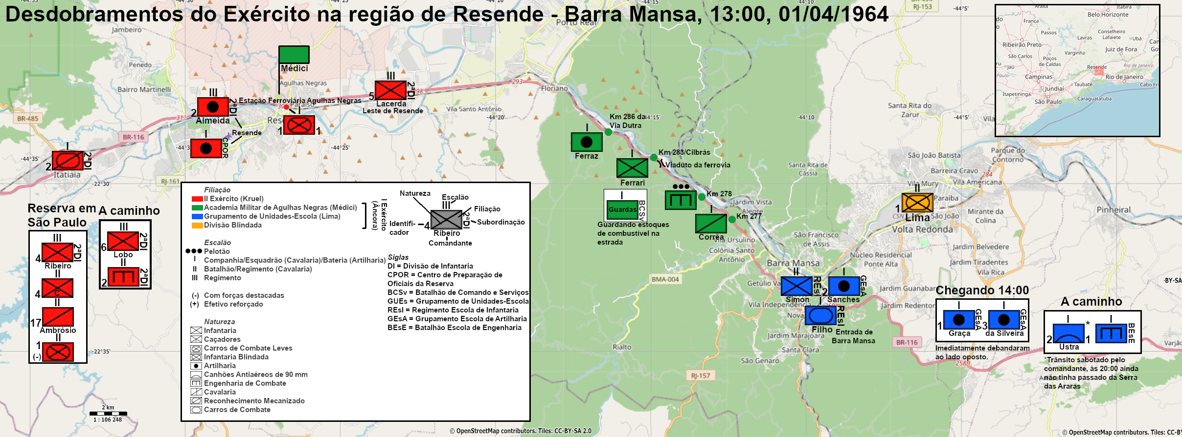
Português: O II Exército de Kruel, aderindo ao golpe militar iniciado em Minas Gerais, deslocou-se a partir da madrugada pelo vale do Paraíba, ao longo da via Dutra, na direção do Rio de Janeiro. O I Exército de Âncora, ainda leal a João Goulart, enviou de manhã o que já estava preparando desde a noite passada, o Grupamento de Unidades-Escola de Anfríso de Rocha Lima. As duas forças prosseguiriam ao combate.
No meio do caminho, a AMAN de Médici tomou partido do II Exército e mobilizou seus cadetes para enfrentar o I Exército na estrada. O 1 BIB de Barra Mansa alinhou-se a Médici e ficou com estrutura muito reduzida em Volta Redonda; existe pouquíssima informação sobre o que ele fez. Os exércitos chegaram a se defrontar, mas fizeram uma trégua pois Âncora seguia à AMAN para negociar com Kruel. Reunidos, o I Exército rendeu-se. |
| Date | |
| Source | OpenStreetMap project data |
| Author | OpenStreetMap contributors + own work |
Licensing
[edit]
| Description |
This map was created from OpenStreetMap project data, collected by the community. This map may be incomplete, and may contain errors. Don't rely solely on it for navigation. |
|||
| Date | (see file history) | |||
| Source | openstreetmap.org | |||
| Creator |
OpenStreetMap contributors |
|||
| Permission (Reusing this file) |
OpenStreetMap data is available under the Open Database License (details). Map tiles are licensed under the Creative Commons Attribution-ShareAlike 2.0 license (CC-BY-SA 2.0).
This file is licensed under the Creative Commons Attribution-Share Alike 2.0 Generic license.
|
|||
| Georeferencing | If inappropriate please set warp_status = skip to hide. |
This documentation is transcluded from File:Situação militar Resende-Barra Mansa 1300 01 04 1964.png/doc.
File history
Click on a date/time to view the file as it appeared at that time.
| Date/Time | Thumbnail | Dimensions | User | Comment | |
|---|---|---|---|---|---|
| current | 17:57, 26 September 2020 | 2,416 × 895 (1.52 MB) | Serraria (talk | contribs) | 1 BCCL | |
| 19:55, 10 August 2020 | 2,416 × 895 (1.52 MB) | Serraria (talk | contribs) | Comandantes, nomenclatura | ||
| 23:08, 11 July 2020 | 2,416 × 895 (1.54 MB) | Serraria (talk | contribs) | Consegui fontes acerca do BEsE e do outro batalhão do REsI | ||
| 19:41, 2 July 2020 | 2,416 × 895 (1.54 MB) | Serraria (talk | contribs) | Nomes de comandantes no GUEs | ||
| 01:33, 24 June 2020 | 2,416 × 895 (1.56 MB) | Serraria (talk | contribs) | Nome do comandante do 1 BIB, ícones de infantaria, removi os engenheiros e cavalaria do GUEs | ||
| 16:01, 3 June 2020 | 2,416 × 895 (1.56 MB) | Serraria (talk | contribs) | Detalhes pequenos e número de batalhões do REsI | ||
| 17:47, 1 June 2020 | 2,416 × 895 (1.56 MB) | Serraria (talk | contribs) | Uploaded a work by OpenStreetMap contributors from OpenStreetMap project data with UploadWizard |
You cannot overwrite this file.
File usage on Commons
There are no pages that use this file.
File usage on other wikis
The following other wikis use this file:
- Usage on en.wikipedia.org
- Usage on pt.wikipedia.org
- Usage on ro.wikipedia.org