File:Sitio arqueologico do Porto Torrao.png
Jump to navigation
Jump to search

Size of this preview: 800 × 370 pixels. Other resolutions: 320 × 148 pixels | 640 × 296 pixels | 1,383 × 640 pixels.
Original file (1,383 × 640 pixels, file size: 270 KB, MIME type: image/png)
Captions
Captions
Add a one-line explanation of what this file represents
Summary
[edit]
| Description |
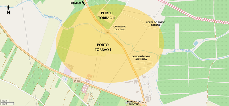
Português: Mapa da área aproximada do sítio arqueológico de Porto Torrão, no concelho de Ferreira do Alentejo, em Portugal. Consiste num recinto de fossos ocupado durante o Neolítico Final e Calcolítico (Porto Torrão I) e numa mancha de ocupação (Porto Torrão II) com vestígios de várias épocas, principalmente romanos. Também está identificado o Condomínio da Azinheira, onde foram descobertos vários materiais e estruturas funerárias do Calcolítico.
English: Map of the approximate area of the archaeological site of Porto Torrão, in the municipality of Ferreira do Alentejo, in southern Portugal. It consists of an enclosure of ditches occupied during the Late Neolithic and Chalcolithic (Porto Torrão I) and an occupation spot (Porto Torrão II) with remains from various periods, mainly Roman. Also identified is the Condomínio da Azinheira (Azinheira condominium), where various materials and funerary structures from the Chalcolithic period were discovered. |
|||||||||||||||
| Date | ||||||||||||||||
| Source |
|
|||||||||||||||
| Author | Ajpvalente and OpenStreetMap contributors |
Licensing
[edit]
This file is licensed under the Creative Commons Attribution-Share Alike 2.0 Generic license.
- You are free:
- to share – to copy, distribute and transmit the work
- to remix – to adapt the work
- Under the following conditions:
- attribution – You must give appropriate credit, provide a link to the license, and indicate if changes were made. You may do so in any reasonable manner, but not in any way that suggests the licensor endorses you or your use.
- share alike – If you remix, transform, or build upon the material, you must distribute your contributions under the same or compatible license as the original.
File history
Click on a date/time to view the file as it appeared at that time.
| Date/Time | Thumbnail | Dimensions | User | Comment | |
|---|---|---|---|---|---|
| current | 04:32, 9 October 2022 | | 1,383 × 640 (270 KB) | Ajpvalente (talk | contribs) | Uploaded a work by Ajpvalente and OpenStreetMap contributors from {{OpenStreetMap}} with UploadWizard |
You cannot overwrite this file.
File usage on Commons
There are no pages that use this file.
File usage on other wikis
The following other wikis use this file:
- Usage on pt.wikipedia.org
- Usage on www.wikidata.org