File:Site BAG navcam CYL L.jpg

Original file (7,688 × 1,896 pixels, file size: 2.69 MB, MIME type: image/jpeg)
Captions
Captions
Summary
[edit]
| Description |
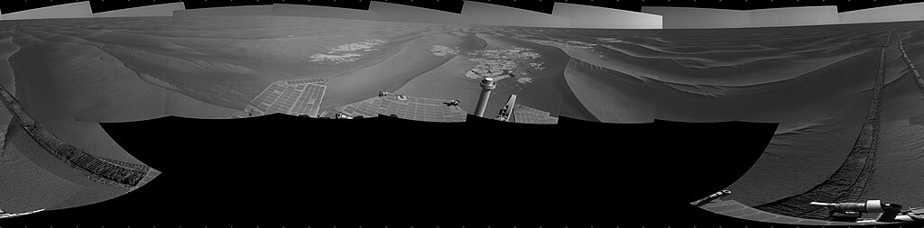
English: NASA's Mars Exploration Rover Opportunity used its navigation camera to take the images combined into this full 360-degree view of the rover's surroundings after a drive on the 2,220th Martian day, or sol, of Opportunity's mission on Mars (April 22, 2010). South is at the center; north at both ends.
Opportunity drove 10.18 meters (33.4 feet) toward the south-southeast on Sol 2220. The drive had been planned to go farther, but one precaution included in the commands sent to Opportunity that sol was for the rover to pause after about 10 meters and check whether its wheels were slipping more than 40 percent. This was a safeguard against having the rover's wheels sink too far into the sand. The slippage had exceeded that amount, so Opportunity did not try to drive farther. After receiving data from the Sol 2220 drive, the rover team assessed the situation and decided that the wheels were not sinking excessively despite the slippage. After recharging batteries, Opportunity continued driving in the same direction six sols later. Opportunity took some of the component images for this mosaic on Sol 2220, after the drive, and the rest on Sol 2221. Wind-formed ripples of dark sand make up much of the terrain surrounding this position. Patches of outcrop are visible to the south. For scale, the distance between the parallel wheel tracks is about 1 meter (about 40 inches). The site is about 6 kilometers (3.7 miles) south-southwest of Victoria Crater. This view is presented as a cylindrical projection with geometric seam correction. |
| Date | |
| Source | http://marsrovers.jpl.nasa.gov/gallery/press/opportunity/20100625a.html |
| Author | NASA |
Licensing
[edit]
| This file is in the public domain in the United States because it was solely created by NASA. NASA copyright policy states that "NASA material is not protected by copyright unless noted". (See Template:PD-USGov, NASA copyright policy page or JPL Image Use Policy.) | ||
 |
Warnings:
|
File history
Click on a date/time to view the file as it appeared at that time.
| Date/Time | Thumbnail | Dimensions | User | Comment | |
|---|---|---|---|---|---|
| current | 21:09, 17 July 2010 | 7,688 × 1,896 (2.69 MB) | Pline (talk | contribs) | {{Information |Description={{en|1=NASA's Mars Exploration Rover Opportunity used its navigation camera to take the images combined into this full 360-degree view of the rover's surroundings after a drive on the 2,220th Martian day, or sol, of Opportunity' |
You cannot overwrite this file.
File usage on Commons
There are no pages that use this file.
File usage on other wikis
The following other wikis use this file:
- Usage on fr.wikipedia.org