File:Sistema de Mapa de Metro Ligeiro de Macau.png
Jump to navigation
Jump to search

Size of this preview: 333 × 598 pixels. Other resolutions: 133 × 240 pixels | 267 × 480 pixels | 427 × 768 pixels | 570 × 1,024 pixels | 2,500 × 4,492 pixels.
Original file (2,500 × 4,492 pixels, file size: 813 KB, MIME type: image/png)
Captions
Captions
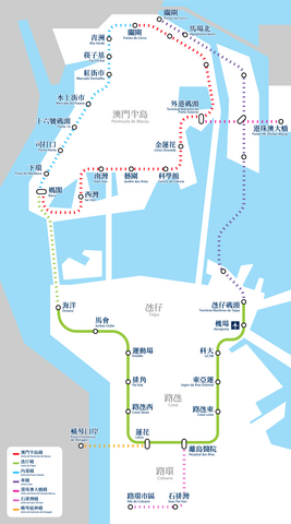
Macau LRT System Map
Summary
[edit]
| Description |
中文(繁體):澳門輕軌系統路線圖
中文(简体):澳门轻轨系统路线图
Português: Mapa da Rede do Metro Ligeiro de Macau
English: Macau LRT System Map |
| Source | Tinho C. (talk) |
| Author | Tinho C. (talk), K. C. Ho (talk) |
Licensing
[edit]
I, the copyright holder of this work, hereby publish it under the following license:
This file is licensed under the Creative Commons Attribution-Share Alike 3.0 Unported license.
- You are free:
- to share – to copy, distribute and transmit the work
- to remix – to adapt the work
- Under the following conditions:
- attribution – You must give appropriate credit, provide a link to the license, and indicate if changes were made. You may do so in any reasonable manner, but not in any way that suggests the licensor endorses you or your use.
- share alike – If you remix, transform, or build upon the material, you must distribute your contributions under the same or compatible license as the original.
File history
Click on a date/time to view the file as it appeared at that time.
| Date/Time | Thumbnail | Dimensions | User | Comment | |
|---|---|---|---|---|---|
| current | 02:07, 3 October 2023 | | 2,500 × 4,492 (813 KB) | Gwingman (talk | contribs) | Updated Lotus Station |
| 18:14, 1 November 2021 |  | 2,500 × 4,492 (830 KB) | Gwingman (talk | contribs) | Remove header | |
| 17:42, 28 December 2020 |  | 2,500 × 4,955 (652 KB) | Gwingman (talk | contribs) | Stronger the stroke | |
| 04:57, 13 October 2020 |  | 2,500 × 4,955 (1.01 MB) | Gwingman (talk | contribs) | Align color with wikipedia's | |
| 02:56, 13 October 2020 |  | 2,500 × 4,955 (1.01 MB) | Gwingman (talk | contribs) | Update Linha Leste | |
| 06:16, 29 June 2019 |  | 2,500 × 4,955 (750 KB) | Gwingman (talk | contribs) | Update according to a report published by CA Macau - http://www.ca.gov.mo/files/SA1318cn.pdf | |
| 20:34, 14 May 2019 |  | 2,500 × 4,955 (770 KB) | Gwingman (talk | contribs) | Improve display of SPV Line | |
| 00:01, 3 May 2019 |  | 2,500 × 4,955 (758 KB) | Gwingman (talk | contribs) | Change SPV Line | |
| 06:59, 8 February 2019 |  | 2,500 × 4,955 (804 KB) | Gwingman (talk | contribs) | 加入模擬字樣 | |
| 06:48, 8 February 2019 |  | 2,500 × 4,955 (798 KB) | Gwingman (talk | contribs) | 改用宋體以強化字重 |
You cannot overwrite this file.
File usage on Commons
The following 28 pages use this file:
- User:Chumwa/OgreBot/Potential transport maps/2018 June 11-20
- User:Chumwa/OgreBot/Potential transport maps/2019 February 1-9
- User:Chumwa/OgreBot/Potential transport maps/2019 June 21-30
- User:Chumwa/OgreBot/Potential transport maps/2019 May 1-10
- User:Chumwa/OgreBot/Potential transport maps/2019 May 11-20
- User:Chumwa/OgreBot/Public transport information/2018 June 11-20
- User:Chumwa/OgreBot/Public transport information/2019 February 1-9
- User:Chumwa/OgreBot/Public transport information/2019 June 21-30
- User:Chumwa/OgreBot/Public transport information/2019 May 1-10
- User:Chumwa/OgreBot/Public transport information/2019 May 11-20
- User:Chumwa/OgreBot/Public transport information/2020 December 21-31
- User:Chumwa/OgreBot/Public transport information/2020 October 11-20
- User:Chumwa/OgreBot/Public transport information/2021 November 1-10
- User:Chumwa/OgreBot/Public transport information/2023 October 1-10
- User:Chumwa/OgreBot/Transport Maps/2018 June 11-20
- User:Chumwa/OgreBot/Transport Maps/2019 February 1-9
- User:Chumwa/OgreBot/Transport Maps/2019 June 21-30
- User:Chumwa/OgreBot/Transport Maps/2019 May 1-10
- User:Chumwa/OgreBot/Transport Maps/2019 May 11-20
- User:Chumwa/OgreBot/Transport Maps/2020 December 21-31
- User:Chumwa/OgreBot/Transport Maps/2020 October 11-20
- User:Chumwa/OgreBot/Transport Maps/2021 November 1-10
- User:Chumwa/OgreBot/Transport Maps/2023 October 1-10
- User:Chumwa/OgreBot/Travel and communication maps/2018 June 11-20
- User:Chumwa/OgreBot/Travel and communication maps/2019 February 1-9
- User:Chumwa/OgreBot/Travel and communication maps/2019 June 21-30
- User:Chumwa/OgreBot/Travel and communication maps/2019 May 1-10
- User:Chumwa/OgreBot/Travel and communication maps/2019 May 11-20
File usage on other wikis
The following other wikis use this file:
- Usage on en.wikipedia.org
- Usage on ja.wikipedia.org
- Usage on ru.wikipedia.org
- Usage on th.wikipedia.org
- Usage on zh-yue.wikipedia.org
- Usage on zh.wikipedia.org