File:Simon Hüttel - Wahrhafftige Beschreibung des gantzen Hriesengebirges.jpg
Jump to navigation
Jump to search
Size of this preview: 715 × 600 pixels. Other resolutions: 286 × 240 pixels | 572 × 480 pixels | 992 × 832 pixels.
Original file (992 × 832 pixels, file size: 1.35 MB, MIME type: image/jpeg)
Captions
Captions
Add a one-line explanation of what this file represents
Summary
[edit]| Description |
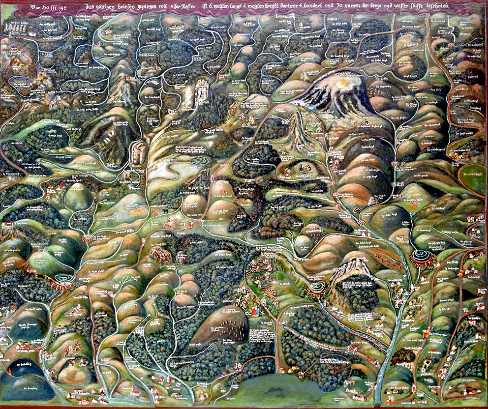
Deutsch: Die älteste Karte des Riesengebirges. English: The oldest map of the Karkonosze Mountains. Français : La carte plus ancienne des monts des Géants. |
| Date | between 1576 and 1585 |
| Source | www.krnap.cz |
| Author | Simon Hüttel |
| Permission (Reusing this file) |
Public domain |
| Other versions |
|
.jpg)
.jpg)
| This is a retouched picture, which means that it has been digitally altered from its original version. Modifications: Verbesserung von Farbe und Kontrast; Photoshop Speicheroptionen: Qualität 12. Modifications made by MagentaGreen.
|
Licensing
[edit]
|
This work is in the public domain in its country of origin and other countries and areas where the copyright term is the author's life plus 70 years or fewer. | |
| This file has been identified as being free of known restrictions under copyright law, including all related and neighboring rights. | |
| Annotations | This image is annotated: View the annotations at Commons |
File history
Click on a date/time to view the file as it appeared at that time.
| Date/Time | Thumbnail | Dimensions | User | Comment | |
|---|---|---|---|---|---|
| current | 15:07, 1 October 2015 | | 992 × 832 (1.35 MB) | MagentaGreen (talk | contribs) | Retouched Picture |
| 15:06, 1 October 2015 |  | 1,000 × 838 (404 KB) | MagentaGreen (talk | contribs) | {{Information |Description={{de|1=Die älteste Karte des Riesengebirges.}}{{en|1=The oldest map of the Karkonosze Mountains.}}{{fr|1=La carte plus ancienne des monts des Géants.}} |Source=[http://www.krnap.cz/data/File/v_krkonosich_jsem_doma/clovek/ma... |
You cannot overwrite this file.
File usage on Commons
The following 3 pages use this file:
.jpg)