File:Sierra de la Morcuera-Cuerda de la Vaqueriza-vertiente sur.jpg
From Wikimedia Commons, the free media repository
Jump to navigation
Jump to search
![File:Sierra de la Morcuera-Cuerda de la Vaqueriza-vertiente sur.jpg](https://upload.wikimedia.org/wikipedia/commons/thumb/8/85/Sierra_de_la_Morcuera-Cuerda_de_la_Vaqueriza-vertiente_sur.jpg/800px-Sierra_de_la_Morcuera-Cuerda_de_la_Vaqueriza-vertiente_sur.jpg?20210706175530)
Size of this preview: 800 × 293 pixels. Other resolutions: 320 × 117 pixels | 640 × 235 pixels | 1,024 × 375 pixels | 1,280 × 469 pixels | 2,560 × 939 pixels | 7,200 × 2,640 pixels.
Original file (7,200 × 2,640 pixels, file size: 10.53 MB, MIME type: image/jpeg)
File information
Structured data
Captions
Captions
Add a one-line explanation of what this file represents
Sierra de la Morcuera y su estribación Cuerda de la Vaqueriza-Vertiente sur
Summary
[edit]DescriptionSierra de la Morcuera-Cuerda de la Vaqueriza-vertiente sur.jpg |
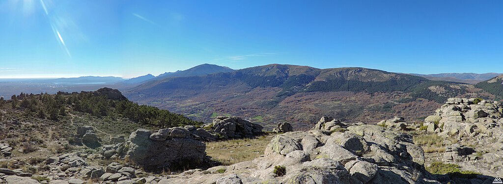
Español: Panorámica de la Sierra de la Morcuera y su estribación de la Cuerda de la Vaqueriza, desde Cabeza Arón en el termino Municipal de Bustarviejo. Sierra de la Morcuera es una alineación montañosa perteneciente a la vertiente sur de la sierra de Guadarrama, en la cordillera del sistema Central, Comunidad de Madrid, España.
English: Panoramic view of the Sierra de la Morcuera and its foothills of the Cuerda de la Vaqueriza, from Cabeza Arón in the municipal area of Bustarviejo, Spain. Sierra de la Morcuera is a mountainous alignment belonging to the southern slope of the Sierra de Guadarrama, in the Central System mountain range, Community of Madrid, Spain. |
Date | |
Source | Own work |
Author | Dinamicgam |
Camera location | 40° 50′ 41.06″ N, 3° 47′ 14.59″ W ![]() | View this and other nearby images on: OpenStreetMap | ![]() |
---|
Licensing
[edit]I, the copyright holder of this work, hereby publish it under the following license:
![w:en:Creative Commons](https://upload.wikimedia.org/wikipedia/commons/thumb/7/79/CC_some_rights_reserved.svg/90px-CC_some_rights_reserved.svg.png)
![attribution](https://upload.wikimedia.org/wikipedia/commons/thumb/1/11/Cc-by_new_white.svg/24px-Cc-by_new_white.svg.png)
![share alike](https://upload.wikimedia.org/wikipedia/commons/thumb/d/df/Cc-sa_white.svg/24px-Cc-sa_white.svg.png)
This file is licensed under the Creative Commons Attribution-Share Alike 4.0 International license.
- You are free:
- to share – to copy, distribute and transmit the work
- to remix – to adapt the work
- Under the following conditions:
- attribution – You must give appropriate credit, provide a link to the license, and indicate if changes were made. You may do so in any reasonable manner, but not in any way that suggests the licensor endorses you or your use.
- share alike – If you remix, transform, or build upon the material, you must distribute your contributions under the same or compatible license as the original.
File history
Click on a date/time to view the file as it appeared at that time.
Date/Time | Thumbnail | Dimensions | User | Comment | |
---|---|---|---|---|---|
current | 17:55, 6 July 2021 | ![]() | 7,200 × 2,640 (10.53 MB) | Dinamicgam (talk | contribs) | Uploaded own work with UploadWizard |
You cannot overwrite this file.
File usage on Commons
There are no pages that use this file.
File usage on other wikis
The following other wikis use this file:
- Usage on es.wikipedia.org
Metadata
This file contains additional information such as Exif metadata which may have been added by the digital camera, scanner, or software program used to create or digitize it. If the file has been modified from its original state, some details such as the timestamp may not fully reflect those of the original file. The timestamp is only as accurate as the clock in the camera, and it may be completely wrong.
Camera manufacturer | NIKON |
---|---|
Camera model | COOLPIX P520 |
Exposure time | 1/1,000 sec (0.001) |
F-number | f/3 |
ISO speed rating | 80 |
Date and time of data generation | 14:12, 21 November 2020 |
Lens focal length | 4.3 mm |
Latitude | 40° 50′ 47.9″ N |
Longitude | 3° 43′ 44.08″ W |
Altitude | 1,559.7 meters above sea level |
Horizontal resolution | 300 dpc |
Vertical resolution | 300 dpc |
Software used | Adobe Photoshop Lightroom Classic 8.0 (Windows) |
File change date and time | 19:22, 6 July 2021 |
Exposure Program | Normal program |
Exif version | 2.3 |
Date and time of digitizing | 14:12, 21 November 2020 |
APEX shutter speed | 9.965784 |
APEX aperture | 3.169925 |
APEX exposure bias | 0 |
Maximum land aperture | 3.2 APEX (f/3.03) |
Metering mode | Pattern |
Light source | Unknown |
Flash | Flash did not fire, compulsory flash suppression |
Color space | sRGB |
File source | Digital still camera |
Scene type | A directly photographed image |
Custom image processing | Normal process |
Exposure mode | Auto exposure |
White balance | Auto white balance |
Digital zoom ratio | 0 |
Focal length in 35 mm film | 24 mm |
Scene capture type | Standard |
Scene control | None |
Contrast | Normal |
Saturation | Normal |
Sharpness | Normal |
Subject distance range | Unknown |
GPS time (atomic clock) | 13:07:55.91 |
Satellites used for measurement | 08 |
Geodetic survey data used | WGS84 |
GPS date | 21 November 2020 |
GPS tag version | 0.0.3.2 |
Date metadata was last modified | 21:22, 6 July 2021 |
Unique ID of original document | 8E098D0EB32B3F060D11777510D4BB15 |
IIM version | 4 |