File:Siegen Karte 1736.jpg
Jump to navigation
Jump to search

Size of this preview: 442 × 600 pixels. Other resolutions: 177 × 240 pixels | 354 × 480 pixels | 942 × 1,278 pixels.
Original file (942 × 1,278 pixels, file size: 1.01 MB, MIME type: image/jpeg)
Captions
Captions
Add a one-line explanation of what this file represents
Summary
[edit]
| Description |
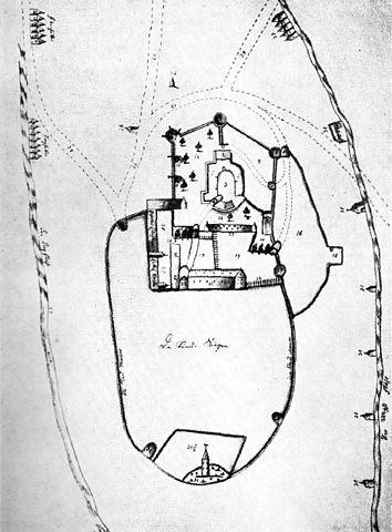
English: City of Siegen (Westphalia, Germany): town map with the Upper Castle (Oberes Schloss). Anonymous drawing, ca. 1736.
Deutsch: Siegen/Westfalen: Karte der Stadt mit Oberem Schloss. Anonyme Zeichnung, angefertigt etwa 1736. |
| Date | circa 1736 |
| Source | Wilhelm Güthling (Hrsg.): Siegerland – Blätter des Siegerländer Heimatvereins e. V., Band 36, Heft 2. Selbstverlag, Siegen 1959 |
| Author | Unknown author |
Licensing
[edit]
|
This is a faithful photographic reproduction of a two-dimensional, public domain work of art. The work of art itself is in the public domain for the following reason:
The official position taken by the Wikimedia Foundation is that "faithful reproductions of two-dimensional public domain works of art are public domain". This photographic reproduction is therefore also considered to be in the public domain in the United States. In other jurisdictions, re-use of this content may be restricted; see Reuse of PD-Art photographs for details. {{PD-Art}} template without license parameter: please specify why the underlying work is public domain in both the source country and the United States
(Usage: {{PD-Art|1=|deathyear=''year of author's death''|country=''source country''}}, where parameter 1= can be PD-old-auto, PD-old-auto-expired, PD-old-auto-1996, PD-old-100 or similar. See Commons:Multi-license copyright tags for more information.) | ||||
File history
Click on a date/time to view the file as it appeared at that time.
| Date/Time | Thumbnail | Dimensions | User | Comment | |
|---|---|---|---|---|---|
| current | 13:13, 8 August 2010 | | 942 × 1,278 (1.01 MB) | Frank Behnsen (talk | contribs) | {{Information |Description={{en|1=City of Siegen (Westphalia, Germany): town map with the Upper Castle ''(Oberes Schloss)''. Anonymous drawing, ca. 1736.}} {{de|1=Siegen/Westfalen: Karte der Stadt mit Oberem Schloss. Anonyme Zeichnung, angefertigt etwa 17 |
You cannot overwrite this file.
File usage on Commons
The following page uses this file:
File usage on other wikis
The following other wikis use this file:
- Usage on de.wikipedia.org