File:Sicily prehellenic topographic mapSimplificado-es.svg
Jump to navigation
Jump to search

Size of this PNG preview of this SVG file: 800 × 533 pixels. Other resolutions: 320 × 213 pixels | 640 × 427 pixels | 1,024 × 683 pixels | 1,280 × 853 pixels | 2,560 × 1,707 pixels | 2,373 × 1,582 pixels.
Original file (SVG file, nominally 2,373 × 1,582 pixels, file size: 430 KB)
Captions
Captions
Add a one-line explanation of what this file represents
Summary
[edit]
| Description |
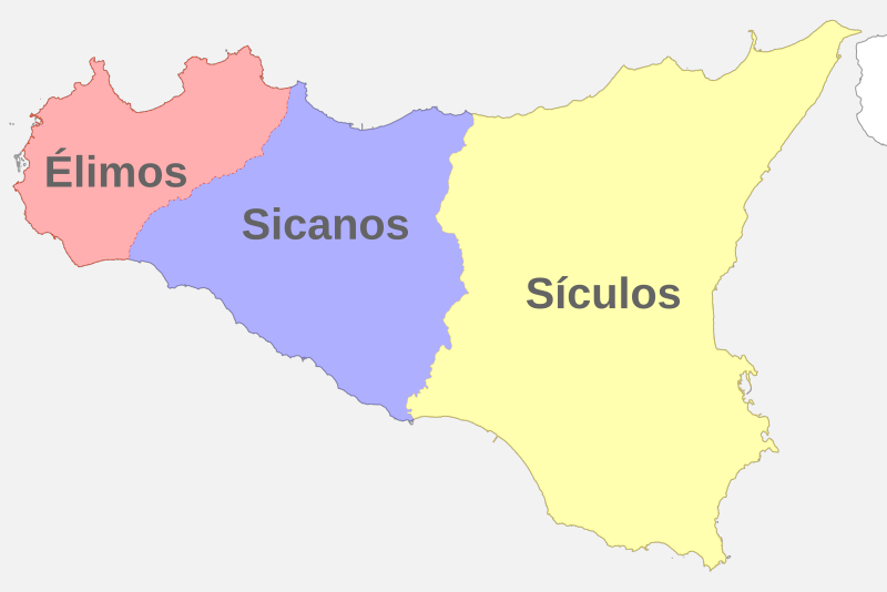
Español: Límites aproximados de los asentamientos élimos, sicanos y sículos en Sicilia. |
| Date | |
| Source | File:Sicily_prehellenic_topographic_map.svg |
| Author | Halibutt |
Licensing
[edit]
This file is licensed under the Creative Commons Attribution-Share Alike 4.0 International license.
- You are free:
- to share – to copy, distribute and transmit the work
- to remix – to adapt the work
- Under the following conditions:
- attribution – You must give appropriate credit, provide a link to the license, and indicate if changes were made. You may do so in any reasonable manner, but not in any way that suggests the licensor endorses you or your use.
- share alike – If you remix, transform, or build upon the material, you must distribute your contributions under the same or compatible license as the original.
File history
Click on a date/time to view the file as it appeared at that time.
| Date/Time | Thumbnail | Dimensions | User | Comment | |
|---|---|---|---|---|---|
| current | 16:47, 3 March 2021 | | 2,373 × 1,582 (430 KB) | Rowanwindwhistler (talk | contribs) | Uploaded a work by Halibutt from https://commons.wikimedia.org/wiki/File:Sicily_prehellenic_topographic_map.svg with UploadWizard |
You cannot overwrite this file.
File usage on Commons
There are no pages that use this file.
File usage on other wikis
The following other wikis use this file:
- Usage on es.wikipedia.org