File:Siccar oli 2018185 lrg.jpg

Original file (4,549 × 4,549 pixels, file size: 3.93 MB, MIME type: image/jpeg)
Captions
Captions
Summary
[edit]
| Description |
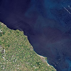
English: One of the central doctrines of geology is a concept called uniformitarianism — the idea that many of Earth’s geologic processes act in the same manner and with the same intensity in the present as they did in the past. For instance, the processes of erosion and sedimentation—which wear down rocks and create sand and dirt—are thought to operate in the same general way now as they did hundreds of millions of years ago.
In the late 18th century, the thinking was rather different. Many people in Western civilization believed the Earth was only 6,000 years old, that all of the world’s rocks had precipitated from the waters of the Biblical flood endured by Noah, and that fossils were relics of animals that had perished in the flood. Scottish farmer and scientist James Hutton was one of the first people to make the conceptual leap into a much deeper and expansive view of time. He helped found the science of geology in the process. After spending decades observing how wind and water weathered rocks and deposited layers of soil at his farm in Berwickshire, while also traveling the Scottish countryside in search of fossils, stream cuts, and interesting rock formations, Hutton became convinced that Earth had to be much older than 6,000 years. In 1788, a boat trip to Siccar Point, a rocky promontory in Berwickshire, helped crystallize Hutton’s view. The Operational Land Imager (OLI) on Landsat 8 acquired this image of the area on June 4, 2018. At Siccar Point, Hutton was confronted with the juxtaposition of two starkly different types of rock—a gently sloping bed of young red sandstone that was over a near vertical slab of older graywacke that had clearly undergone intensive heating, uplift, buckling, and folding. Hutton argued to his two companions on the boat that the only way to get the two rock formations jammed up against one another at such an odd angle was that an enormous amount of time must have elapsed between when they had been deposited at the bottom of the ocean. He was right. Geologists now know that tens of millions of years elapsed between when the graywacke and sandstone rock layers formed—years in which intense pressure from shifting tectonic plates and erosion from wind and waves did much to reshape and reorient them before ultimately bringing them together at Siccar Point. “On us who saw these phenomena for the first time, the impression made will not easily be forgotten,” said John Playfair, one of Hutton’s companions on the boat trip. “The mind seemed to grow giddy by looking so far into the abyss of time.”Deutsch: Einer der zentralen Lehrsätze der Geologie ist ein Konzept mit dem Namen Aktualismus – der Idee dass viele der geologischen Abläufe auf der Erde heute auf dieselbe Weise und in derselben Intensität ablaufen, wie sie das in der Vergangenheit taten. Zum Beispiel geht man davon aus, dass die Abläufe der Erosion und Sedimentation — die Felsen zersetzen und Sand und Erde schaffen — heute grundsätzlich genauso verlaufen, wie sie das schon vor hunderten von Millionen Jahren getan haben.
Ende des 18. Jahrhunderts dachte man noch anders. Viele Menschen in der westlichen Welt glaubten daran, dass die Erde nur 6000 Jahre alt sei, dass alle Gebirge der Welt von den Wassern der biblischen Flut überschwemmt wurden, die Noah elebt hatte und dass Fossilien die Überbleibsel seien von Tieren, die in dieser Flut umgekommen waren. Der schottische Farmer und Wissenschaftler James Hutton war einer der ersten, die den Gedankenschritt in eine viel tiefere und ausgedehntere Sicht der Zeit machten. Damit half er der Wissenschaft der Geologie bei ihrer Gründung. Nachdem er über Jahrzehnte hinweg beobachtet hatte, wie Wind und Wasser Gestein verwitterten und verschiedene Schichten Boden auf seiner Farm in Berwickshire ablagerten, während er außerdem die schottische Provinz bereiste, um nach Fossilien, Taleinschnitten und interessanten Felsformationen zu suchen, gelangte Hutton zur Überzeugung, dass die Erde sehr viel älter sein muss als 6000 Jahre. Eine 1788 unternommene Bootsfahrt nach Siccar Point, einem felsigen Vorgebirge in Berwickshire, trug dazu bei, Huttons Ansichten zu kristallisieren. Der Operational Land Imager (OLI) auf dem Landsat 8 nahm am 4. Juni 2018 dieses Bild von dem Gebiet auf. Bei Siccar Point sah sich Hutton konfrontiert mit dem Nebeneinander zweier höchst unterschiedlicher Gesteinstypen — einer Leicht ansteigenden Lage jungen roten Sandsteins, die eine fast senkrecht ausgerichete Schicht älterer Grauwacke überlagerte, die eindeutig intensiver Erhitzung, Hebung, Knickung und Faltung ausgesetzt war. Hutton diskutierte mit seinen beiden Begleitern im Boot darüber, dass die einzige Möglichkeit, in der diese beiden Felsformationen in solch einem ungewöhnlichen Winkel übereinander gelagert wurden, sei, dass ein Menge Zeit dazwischen vergangen sein musste, als diese sich am Boden des Meeres abgelagert haben. Er hatte recht. Geologen wissen jetzt, dass zwischen der Bildung der Grauwacken- und Sandsteinschichten Dutzende von Millionen Jahren vergangen sind — eine Zeit, in denen starker Druck von der Verschiebung der tektonischen Platten und Erosion durch Wind und Wellen viel dazu beitrugen, die Schichten umzuformen und auszurichten, bis sie schließlich an Siccar Point zusammengefügt wurden. “Auf uns, die dieses Phänomen zum ersten Mal erblickt haben, macht es einen nicht so schnell zu vergessenden Eindruck”, sagte John Playfair, einer von Huttons Gefährten auf dem Bootstrip. “Der Verstand scheint schwindlig zu werden, wenn man so weit in den Abgrund der Zeit hineinschaut.” |
| Date | |
| Source | https://earthobservatory.nasa.gov/images/92598/the-abyss-of-time |
| Author | NASA Earth Observatory image by Joshua Stevens, using Landsat data from the U.S. Geological Survey. Story by Adam Voiland. |
| Other versions |
 low res, labeled |
References and Related Reading
[edit]
- American Museum of Natural History James Hutton: The Founder of Modern Geology. Accessed August 1, 2018.
- Edinburgh Geological Society James Hutton. archive copy at the Wayback Machine Accessed August 1, 2018.
- GeoWalks Siccar Point, Borders Coast. Accessed August 1, 2018.
- National Center for Science Education Siccar Point. Accessed August 1, 2018.
- Smithsonian (2016, August 26) The Blasphemous Geologist Who Rocked Our Understanding of Earth’s Age. Accessed August 1, 2018.
Licensing
[edit]
This image is in the public domain in the United States because it only contains materials that originally came from the United States Geological Survey, an agency of the United States Department of the Interior. For more information, see the official USGS copyright policy.
|
File history
Click on a date/time to view the file as it appeared at that time.
| Date/Time | Thumbnail | Dimensions | User | Comment | |
|---|---|---|---|---|---|
| current | 11:45, 20 October 2020 | | 4,549 × 4,549 (3.93 MB) | Matthiasb (talk | contribs) | {{Information |description ={{en|1=One of the central doctrines of geology is a concept called w:uniformitarianism — the idea that many of Earth’s geologic processes act in the same manner and with the same intensity in the present as they did in the past. For instance, the processes of erosion and sedimentation—which wear down rocks and create sand and dirt—are thought to operate in the same general way now as they did hundreds of millions of years ago. In the late 18th century, the... |
You cannot overwrite this file.
File usage on Commons
The following page uses this file: