File:Shuttle Landing Facility.jpg
Jump to navigation
Jump to search
Size of this preview: 800 × 532 pixels. Other resolutions: 320 × 213 pixels | 640 × 426 pixels | 1,024 × 681 pixels | 1,280 × 851 pixels | 3,008 × 2,000 pixels.
Original file (3,008 × 2,000 pixels, file size: 1.06 MB, MIME type: image/jpeg)
Captions
Captions
Add a one-line explanation of what this file represents
Summary
[edit]
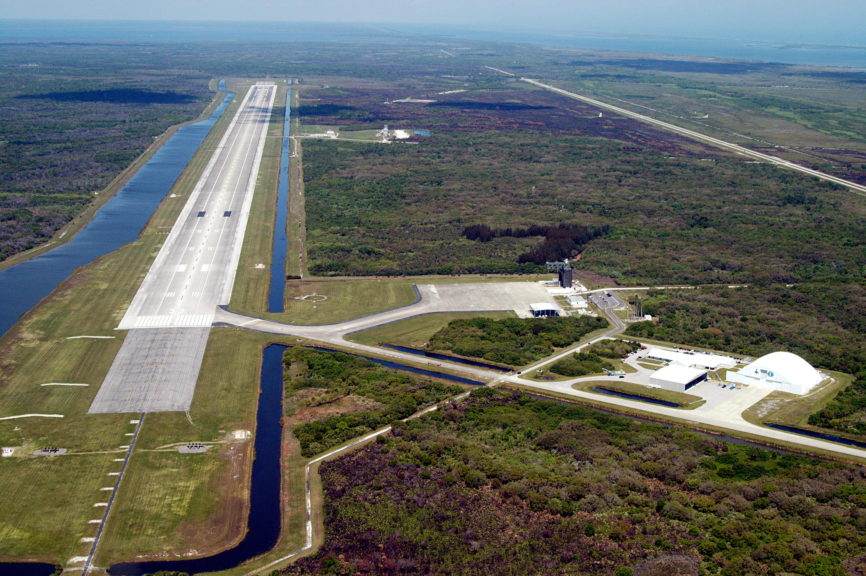
| Description | This aerial photo of the runway at the KSC Shuttle Landing Facility looks northwest. Longer and wider than most commercial runways, it is about 15,000 feet long, with 1,000-foot paved overruns on each end, and 300 feet wide, with 50-foot asphalt shoulders. The runway is used by military and civilian cargo carriers, astronauts’ T-38 trainers, Shuttle Training Aircraft and helicopters, as well as the Space Shuttle. At center right is the parking apron with the orbiter mate/demate tower. The tow-way stretches from the runway to the right, passing the hangar and storage facilities. A grassy area next to the mid-point of the runway is where the new control tower is located. |
| Date | Taken on 31 March 2004 |
| Source | |
| Author | NASA |
This image or video was catalogued by Kennedy Space Center of the United States National Aeronautics and Space Administration (NASA) under Photo ID: KSC-04PD-0938 and Alternate ID: KSC-04pd0938. This tag does not indicate the copyright status of the attached work. A normal copyright tag is still required. See Commons:Licensing. Other languages:
|
Licensing
[edit]
| This file is in the public domain in the United States because it was solely created by NASA. NASA copyright policy states that "NASA material is not protected by copyright unless noted". (See Template:PD-USGov, NASA copyright policy page or JPL Image Use Policy.) | ||
 |
Warnings:
|
| Annotations | This image is annotated: View the annotations at Commons |
File history
Click on a date/time to view the file as it appeared at that time.
| Date/Time | Thumbnail | Dimensions | User | Comment | |
|---|---|---|---|---|---|
| current | 17:26, 19 February 2009 | | 3,008 × 2,000 (1.06 MB) | TheDJ (talk | contribs) | {{Information |Description=This aerial photo of the runway at the KSC Shuttle Landing Facility looks northeast. Longer and wider than most commercial runways, it is 15,000 feet long, with 1,000-foot paved overruns on each end, and 300 feet wide, with 50-f |
You cannot overwrite this file.
File usage on Commons
There are no pages that use this file.
File usage on other wikis
The following other wikis use this file:
- Usage on de.wikipedia.org
- Usage on fa.wikipedia.org
- Usage on fr.wikipedia.org
- Usage on hi.wikipedia.org
- Usage on id.wikipedia.org
- Usage on it.wikipedia.org
- Usage on ja.wikipedia.org
- Usage on lb.wikipedia.org
- Usage on nl.wikipedia.org
- Usage on nn.wikipedia.org
- Usage on no.wikipedia.org
- Usage on pl.wikipedia.org
- Usage on ur.wikipedia.org