File:Shutoken chikeizu01.png
Jump to navigation
Jump to search

Size of this preview: 800 × 429 pixels. Other resolutions: 320 × 172 pixels | 640 × 343 pixels | 1,024 × 549 pixels | 1,600 × 858 pixels.
Original file (1,600 × 858 pixels, file size: 1.21 MB, MIME type: image/png)
Captions
Captions
Add a one-line explanation of what this file represents
Summary
[edit]
| Description |
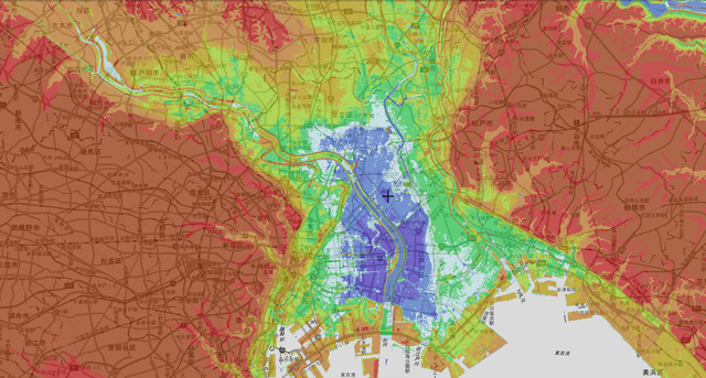
日本語: 東京首都圏の地形図。青い地域は東京湾の水位より地面が低くなっている地域。左右の標高が高い地域は武蔵野台地と下総台地である。国土地理院の地形図を元に投稿者が作成。
English: Topographic map of Tokyo metropolitan area. The blue area is where the ground level is lower than the water level of Tokyo Bay. The high altitude areas where the left and right are the Musashino Plateau and the Shimosa Plateau. The author creates this topographic map with the permission of the Geographical Survey Institute of Japan.
Deutsch: Topografische Karte der Metropolregion Tokio. Im blauen Bereich ist der Boden niedriger als der Wasserstand der Bucht von Tokio. Die Höhengebiete, in denen links und rechts das Musashino-Plateau und das Shimosa-Plateau liegen. Der Autor erstellt diese topografische Karte mit Genehmigung des Geographical Survey Institute of Japan. |
| Date | |
| Source | Own work |
| Author | 1500年前の古墳 |
Licensing
[edit]
I, the copyright holder of this work, hereby publish it under the following license:
This file is licensed under the Creative Commons Attribution-Share Alike 4.0 International license.
- You are free:
- to share – to copy, distribute and transmit the work
- to remix – to adapt the work
- Under the following conditions:
- attribution – You must give appropriate credit, provide a link to the license, and indicate if changes were made. You may do so in any reasonable manner, but not in any way that suggests the licensor endorses you or your use.
- share alike – If you remix, transform, or build upon the material, you must distribute your contributions under the same or compatible license as the original.
File history
Click on a date/time to view the file as it appeared at that time.
| Date/Time | Thumbnail | Dimensions | User | Comment | |
|---|---|---|---|---|---|
| current | 12:34, 13 April 2020 | | 1,600 × 858 (1.21 MB) | 1500年前の古墳 (talk | contribs) | Uploaded own work with UploadWizard |
You cannot overwrite this file.
File usage on Commons
The following page uses this file:
File usage on other wikis
The following other wikis use this file:
- Usage on ja.wikipedia.org