File:Shrinking Aral Sea (15225687200).jpg
Original file (4,000 × 2,000 pixels, file size: 2.28 MB, MIME type: image/jpeg)
Captions
Captions
Summary
[edit].jpg&action=edit§ion=1)
| Description |
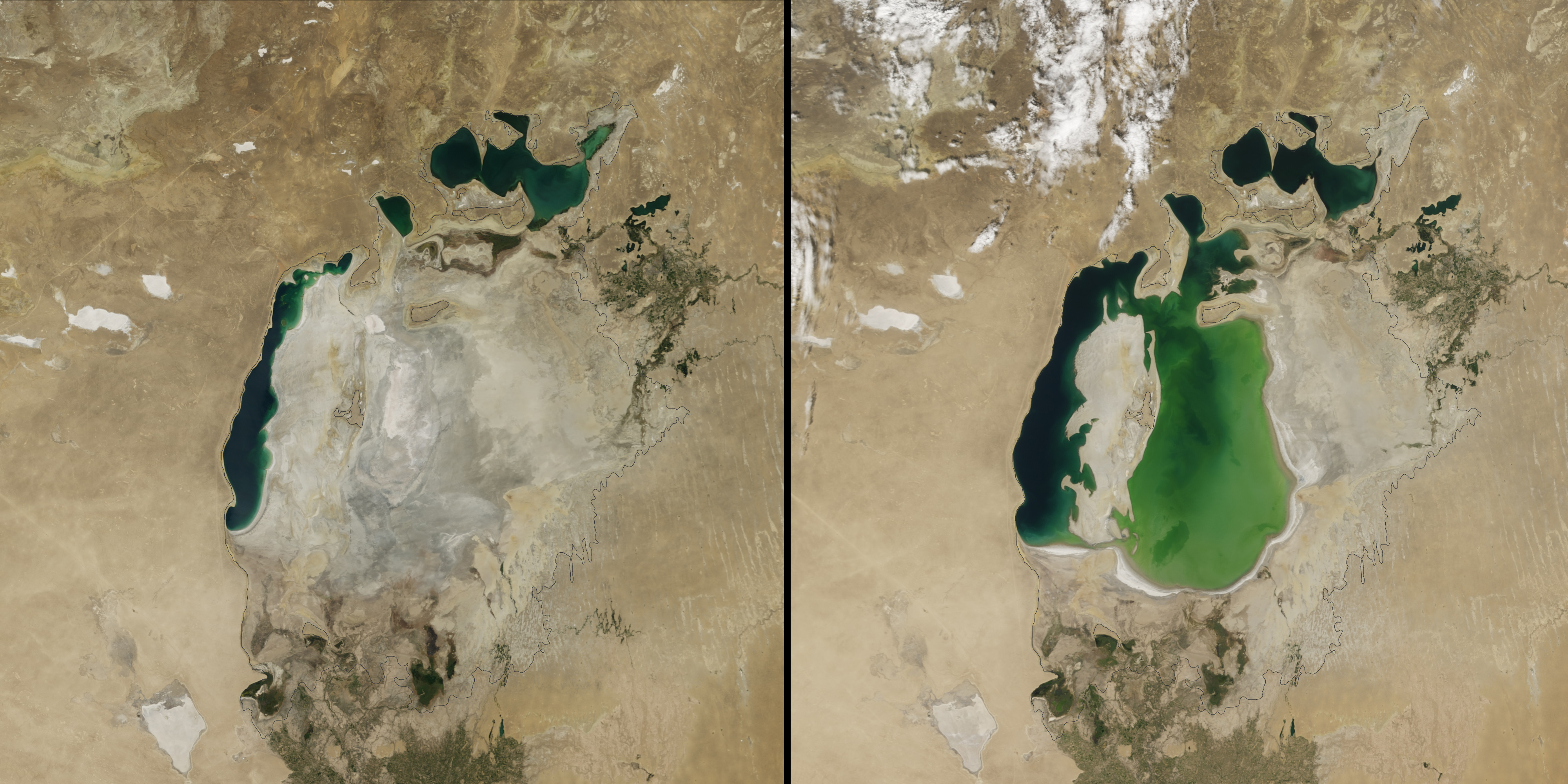
(Aral Sea: left 2014 and right 2000, 1960 extent black line) In the 1960s, the Soviet Union undertook a major water diversion project on the arid plains of Kazakhstan, Uzbekistan, and Turkmenistan. The region’s two major rivers, fed by snowmelt and precipitation in faraway mountains, were used to transform the desert into farms for cotton and other crops. Before the project, the Syr Darya and the Amu Darya rivers flowed down from the mountains, cut northwest through the Kyzylkum Desert, and finally pooled together in the lowest part of the basin. The lake they made, the Aral Sea, was once the fourth largest in the world. Although irrigation made the desert bloom, it devastated the Aral Sea. This series of images from the Moderate Resolution Imaging Spectroradiometer (MODIS) on NASA’s Terra satellite documents the changes. At the start of the series in 2000, the lake was already a fraction of its 1960 extent (black line). The Northern Aral Sea (sometimes called the Small Aral Sea) had separated from the Southern (Large) Aral Sea. The Southern Aral Sea had split into eastern and western lobes that remained tenuously connected at both ends. By 2001, the southern connection had been severed, and the shallower eastern part retreated rapidly over the next several years. Especially large retreats in the eastern lobe of the Southern Sea appear to have occurred between 2005 and 2009, when drought limited and then cut off the flow of the Amu Darya. Water levels then fluctuated annually between 2009 and 2014 in alternately dry and wet years. Dry conditions in 2014 caused the Southern Sea’s eastern lobe to completely dry up for the first time in modern times. Continue reading: 1.usa.gov/1nLX9Ku Read more: 1.usa.gov/1pqEnDj Credit: NASA Earth Observatory NASA image use policy. NASA Goddard Space Flight Center enables NASA’s mission through four scientific endeavors: Earth Science, Heliophysics, Solar System Exploration, and Astrophysics. Goddard plays a leading role in NASA’s accomplishments by contributing compelling scientific knowledge to advance the Agency’s mission. Follow us on Twitter Like us on Facebook Find us on Instagram |
| Date | |
| Source | Shrinking Aral Sea |
| Author | NASA Goddard Space Flight Center from Greenbelt, MD, USA |
Licensing
[edit].jpg&action=edit§ion=2)
- You are free:
- to share – to copy, distribute and transmit the work
- to remix – to adapt the work
- Under the following conditions:
- attribution – You must give appropriate credit, provide a link to the license, and indicate if changes were made. You may do so in any reasonable manner, but not in any way that suggests the licensor endorses you or your use.
| This image was originally posted to Flickr by NASA Goddard Photo and Video at https://flickr.com/photos/24662369@N07/15225687200. It was reviewed on 17 September 2016 by FlickreviewR and was confirmed to be licensed under the terms of the cc-by-2.0. |
| This file is in the public domain in the United States because it was solely created by NASA. NASA copyright policy states that "NASA material is not protected by copyright unless noted". (See Template:PD-USGov, NASA copyright policy page or JPL Image Use Policy.) | ||
 |
Warnings:
|
File history
Click on a date/time to view the file as it appeared at that time.
| Date/Time | Thumbnail | Dimensions | User | Comment | |
|---|---|---|---|---|---|
| current | 20:25, 17 September 2016 | | 4,000 × 2,000 (2.28 MB) | Vanished Account Byeznhpyxeuztibuo (talk | contribs) | Transferred from Flickr via Flickr2Commons |
You cannot overwrite this file.
File usage on Commons
There are no pages that use this file.
File usage on other wikis
The following other wikis use this file:
- Usage on de.wikipedia.org
.jpg&oldid=892703194)