File:ShrewsburyWards.jpg
Jump to navigation
Jump to search

Size of this preview: 800 × 503 pixels. Other resolutions: 320 × 201 pixels | 640 × 402 pixels | 1,088 × 684 pixels.
Original file (1,088 × 684 pixels, file size: 270 KB, MIME type: image/jpeg)
Captions
Captions
Add a one-line explanation of what this file represents
Summary
[edit]
| Description |
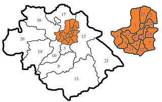
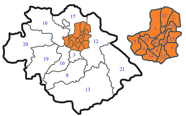
English: A map of the wards of en:Shrewsbury and Atcham district. Self created.
Key:
1 Bagley |
| Date | 12 June 2007 (original upload date) |
| Source | Transferred from en.wikipedia |
| Author | Original uploader was Asdfasdf1231234 at en.wikipedia |
| Permission (Reusing this file) |
Released under the GNU Free Documentation License. |
Licensing
[edit]

|
Permission is granted to copy, distribute and/or modify this document under the terms of the GNU Free Documentation License, Version 1.2 or any later version published by the Free Software Foundation; with no Invariant Sections, no Front-Cover Texts, and no Back-Cover Texts. A copy of the license is included in the section entitled GNU Free Documentation License. |
| This file is licensed under the Creative Commons Attribution-Share Alike 3.0 Unported license. | ||
| ||
| This licensing tag was added to this file as part of the GFDL licensing update. |
Original upload log
[edit]
The original description page was here. All following user names refer to en.wikipedia.
- 2007-06-12 10:59 Asdfasdf1231234 1088×684×8 (276048 bytes) A map of the wards of [[Shrewsbury and Atcham]] district. Self created. Key: 1 Bagley<br> 2 Battlefield and Heathgates<br> 3 Bayston Hill<br> 4 Belle Vue<br> 5 Bowbrook<br> 6 Castlefields and Quarry<br> 7 Column<br> 8 Condover<br> 9 Copthorne<br> 10 Han
File history
Click on a date/time to view the file as it appeared at that time.
| Date/Time | Thumbnail | Dimensions | User | Comment | |
|---|---|---|---|---|---|
| current | 14:49, 25 April 2008 | | 1,088 × 684 (270 KB) | Montehermoso-spain (talk | contribs) | {{Information |Description={{en|A map of the wards of en:Shrewsbury and Atcham district. Self created. Key: 1 Bagley<br> 2 Battlefield and Heathgates<br> 3 Bayston Hill<br> 4 Belle Vue<br> 5 Bowbrook<br> 6 Castlefields and Quarry<br> 7 Column<br> 8 |
You cannot overwrite this file.
File usage on Commons
There are no pages that use this file.
File usage on other wikis
The following other wikis use this file:
- Usage on ast.wikipedia.org
- Usage on es.wikipedia.org