File:Shimanek Bridge, Scio, OR (6563854831).jpg
Shimanek_Bridge,_Scio,_OR_(6563854831).jpg (640 × 426 pixels, file size: 123 KB, MIME type: image/jpeg)
Captions
Captions
Summary
[edit].jpg&action=edit§ion=1)
| Description |
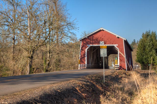
As Linn County's newest and longest covered span, the Shimanek Bridge offers an exception to the usual open-sided structure with rounded portals. Red paint, portal design and louvered windows are features similar to the former span, which was built in 1927, and found on no other bridge in Linn County. Rods in the truss are grouped into a series of four instead of the usual three at each compression joint. The bridge shares the white painted interior of other Linn County bridges. In 2002, a Linn County bridge crew repaired damage caused by the 1996 flood. The crew also replaced the horizontal housing material on the south end, and the structure was then repainted. The first bridge built at this location is believed to have been constructed as early as 1861, while the first documented covered bridge was built in 1891 for a cost of $1,150. In 1904, the county rebuilt the bridge, only to have it washed out in 1921. Its replacement lasted until 1927, when high water damaged the piers and the span was replaced. Trees were blown against the fourth covered bridge at this site during the Columbus Day Storm of 1962. The resulting damage forced the county to restrict the covered bridge to a 2-ton load limit with single lane traffic. The bridge was destroyed soon after, and in 1966 the current Shimanek Bridge was completed, the fifth covered bridge to occupy this site. It has been rumored that the 1891 bridge had a welcomed accommodation of a two-hole toilet built into the foundation, a luxury not found at the current covered bridge. |
| Date | |
| Source |
|
| Author | Sandy Horvath-Dori from Grand Junction, CO, USA |
| Camera location | | View this and other nearby images on: OpenStreetMap |
|---|
.jpg¶ms=044.711732_N_-122.770242_E_globe:Earth_type:camera_source:Flickr_&language=en)
Licensing
[edit].jpg&action=edit§ion=2)
- You are free:
- to share – to copy, distribute and transmit the work
- to remix – to adapt the work
- Under the following conditions:
- attribution – You must give appropriate credit, provide a link to the license, and indicate if changes were made. You may do so in any reasonable manner, but not in any way that suggests the licensor endorses you or your use.
| This image, originally posted to Flickr, was reviewed on 2 February 2014 by the administrator or reviewer File Upload Bot (Magnus Manske), who confirmed that it was available on Flickr under the stated license on that date. |
File history
Click on a date/time to view the file as it appeared at that time.
| Date/Time | Thumbnail | Dimensions | User | Comment | |
|---|---|---|---|---|---|
| current | 02:11, 2 February 2014 | | 640 × 426 (123 KB) | File Upload Bot (Magnus Manske) (talk | contribs) | Transferred from Flickr by User:AlbertHerring |
You cannot overwrite this file.
File usage on Commons
There are no pages that use this file.
.jpg&oldid=798457010)