File:Shetland UK relief location map.jpg
Jump to navigation
Jump to search

Size of this preview: 315 × 599 pixels. Other resolutions: 126 × 240 pixels | 252 × 480 pixels | 404 × 768 pixels | 538 × 1,024 pixels | 1,999 × 3,802 pixels.
Original file (1,999 × 3,802 pixels, file size: 505 KB, MIME type: image/jpeg)
Captions
Captions
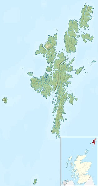
Relief map of the Shetland Islands, United Kingdom
| Description |
Relief map of the Shetland Islands, UK. Equirectangular map projection on WGS 84 datum, with N/S stretched 200% Geographic limits:
|
| Date | |
| Source |
|
| Author | Nilfanion, created using Ordnance Survey data |
| Permission (Reusing this file) |
This file is licensed under the Creative Commons Attribution-Share Alike 3.0 Unported license. Attribution: Contains Ordnance Survey data © Crown copyright and database right
|
| Other versions | File:Shetland UK blank map.svg - Blank map |
File history
Click on a date/time to view the file as it appeared at that time.
| Date/Time | Thumbnail | Dimensions | User | Comment | |
|---|---|---|---|---|---|
| current | 12:29, 30 November 2011 | | 1,999 × 3,802 (505 KB) | Nilfanion (talk | contribs) | {{Information |Description=Relief map of the Shetland Islands, UK. Equirectangular map projection on WGS 84 datum, with N/S stretched 200% Geographic limits: *West: 2.15W *East: 0.70W *North: 60.88N *South: 59.50N |Source=[[w:Ordn |
You cannot overwrite this file.
File usage on Commons
The following 4 pages use this file:
File usage on other wikis
The following other wikis use this file:
- Usage on ar.wikipedia.org
- Usage on ast.wikipedia.org
- Usage on bg.wikipedia.org
- Usage on ca.wikipedia.org
- Usage on ceb.wikipedia.org
- Usage on da.wikipedia.org
- Usage on de.wikipedia.org
- Whalsay
- Muckle Roe
- Trondra
- West Burra
- East Burra
- Muckle Flugga
- Mousa
- Balta (Insel)
- Vorlage:Positionskarte Schottland Shetland
- Loch of Spiggie
- Gruney
- Ramna Stacks
- Burra Voe (Northmavine)
- Loch of Cliff
- Loch of Housetter
- St Magnus Bay
- The Heag (Vementry)
- The Heag (West Burrafirth)
- West Burrafirth (Insel)
- Usage on de.wikivoyage.org
- Usage on en.wikipedia.org
View more global usage of this file.