File:SheshonqI Canaan.jpg
Jump to navigation
Jump to search
Size of this preview: 511 × 599 pixels. Other resolutions: 205 × 240 pixels | 409 × 480 pixels | 657 × 770 pixels.
Original file (657 × 770 pixels, file size: 123 KB, MIME type: image/jpeg)
Captions
Captions
Add a one-line explanation of what this file represents
Summary
[edit]
| Description |
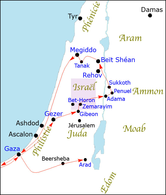
English: The map shows the route of Sheshonq 1 military campaign in Canaan. The names of the cities written in blue are those which appear in the relief of Karnak. Drawn using Mario Liverani, Israel's History and the History of Israel, p.102, and Karnak sources.
Français : La carte montre l'itinéraire de la campagne militaire de Sheshonq 1er en Canaan. Les noms des villes écrits en bleu sont ceux qui figurent dans le relief de Karnak. Dessiné en utilisant Mario Liverani, Israel's History and the History of Israel, p.102, et des sources sur Karnak.
العربية: تُظهر الخريطة مسار حملة شيشنق 1 العسكرية في كنعان. أسماء المدن المكتوبة باللون الأزرق هي تلك التي تظهر في نقش الكرنك. رسم باستخدام ماريو ليفيراني ، تاريخ إسرائيل، ص 102 ، ومصادر الكرنك. |
| Date | |
| Source | Own work |
| Author | Claude Valette |
Licensing
[edit]
I, the copyright holder of this work, hereby publish it under the following licenses:

|
Permission is granted to copy, distribute and/or modify this document under the terms of the GNU Free Documentation License, Version 1.2 or any later version published by the Free Software Foundation; with no Invariant Sections, no Front-Cover Texts, and no Back-Cover Texts. A copy of the license is included in the section entitled GNU Free Documentation License. |
This file is licensed under the Creative Commons Attribution-Share Alike 4.0 International, 3.0 Unported, 2.5 Generic, 2.0 Generic and 1.0 Generic license.
- You are free:
- to share – to copy, distribute and transmit the work
- to remix – to adapt the work
- Under the following conditions:
- attribution – You must give appropriate credit, provide a link to the license, and indicate if changes were made. You may do so in any reasonable manner, but not in any way that suggests the licensor endorses you or your use.
- share alike – If you remix, transform, or build upon the material, you must distribute your contributions under the same or compatible license as the original.
You may select the license of your choice.
File history
Click on a date/time to view the file as it appeared at that time.
| Date/Time | Thumbnail | Dimensions | User | Comment | |
|---|---|---|---|---|---|
| current | 16:01, 1 September 2010 | | 657 × 770 (123 KB) | Claude Valette (talk | contribs) | {{Information |Description={{en|1=The map shows the route of Sheshonq 1 military campaign in Canaan. The names of the cities written in blue are those which appear in the relief of Karnak. Drawn using Mario Liverani, Israel's History and the History of Is |
You cannot overwrite this file.
File usage on Commons
There are no pages that use this file.
File usage on other wikis
The following other wikis use this file:
- Usage on ar.wikipedia.org
- Usage on de.wikipedia.org
- Usage on fr.wikipedia.org
- Usage on nl.wikipedia.org
- Usage on sv.wikipedia.org