File:Shenzhen Metro (Rapid Transit) System Map.png
Jump to navigation
Jump to search

Size of this preview: 800 × 448 pixels. Other resolutions: 320 × 179 pixels | 640 × 359 pixels | 1,024 × 574 pixels | 1,280 × 717 pixels | 2,560 × 1,435 pixels | 6,124 × 3,432 pixels.
Original file (6,124 × 3,432 pixels, file size: 1.12 MB, MIME type: image/png)
Captions
Captions
Add a one-line explanation of what this file represents

|
This image could be re-created using vector graphics as an SVG file. This has several advantages; see Commons:Media for cleanup for more information. If an SVG form of this image is available, please upload it and afterwards replace this template with
{{vector version available|new image name}}.
It is recommended to name the SVG file “Shenzhen Metro (Rapid Transit) System Map.svg”—then the template Vector version available (or Vva) does not need the new image name parameter. |
Summary
[edit]_System_Map.png&action=edit§ion=1)
| Description |
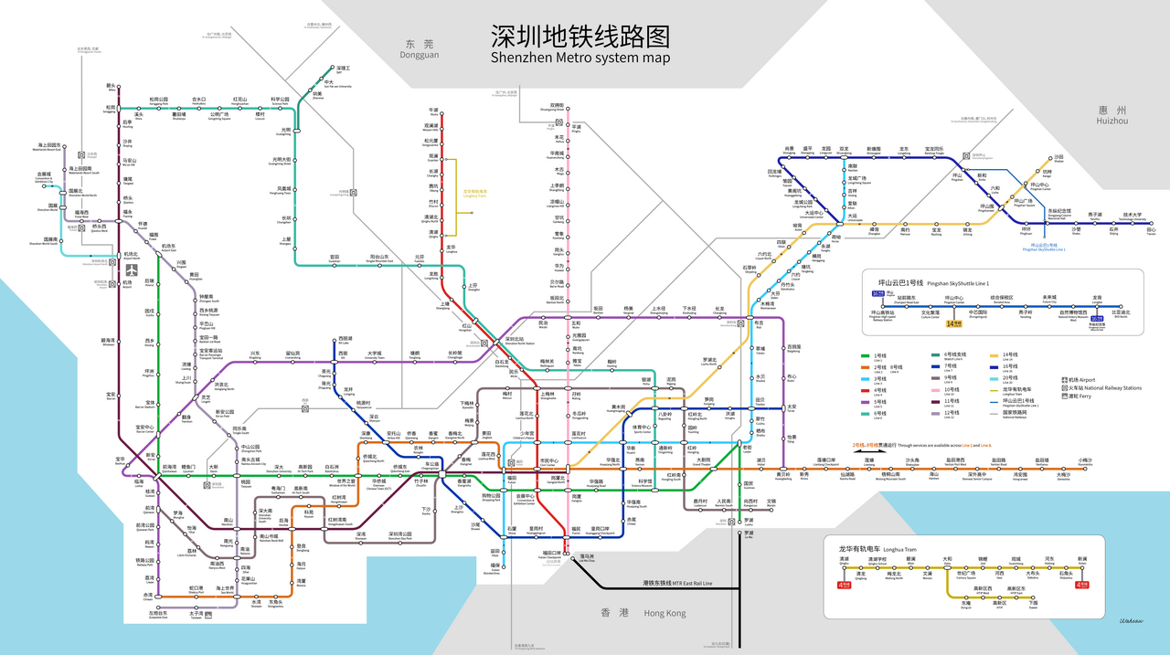
中文:深圳地铁系统图(2022年12月)
English: System Map of Shenzhen Metro (Rapid Transit) as of December, 2022 |
| Date | |
| Source | Own work |
| Author | Wahsaw |
Licensing
[edit]_System_Map.png&action=edit§ion=2)
I, the copyright holder of this work, hereby publish it under the following license:
This file is licensed under the Creative Commons Attribution-Share Alike 4.0 International license.
- You are free:
- to share – to copy, distribute and transmit the work
- to remix – to adapt the work
- Under the following conditions:
- attribution – You must give appropriate credit, provide a link to the license, and indicate if changes were made. You may do so in any reasonable manner, but not in any way that suggests the licensor endorses you or your use.
- share alike – If you remix, transform, or build upon the material, you must distribute your contributions under the same or compatible license as the original.
File history
Click on a date/time to view the file as it appeared at that time.
_System_Map.png&dir=prev)
_System_Map.png&offset=20190625151407)
_System_Map.png&offset=&limit=20)
_System_Map.png&offset=&limit=50)
_System_Map.png&offset=&limit=100)
_System_Map.png&offset=&limit=250)
_System_Map.png&offset=&limit=500)
| Date/Time | Thumbnail | Dimensions | User | Comment | |
|---|---|---|---|---|---|
| current | 12:37, 4 January 2024 | | 6,124 × 3,432 (1.12 MB) | Wahsaw (talk | contribs) | Line 8 phase II |
| 07:48, 24 January 2023 |  | 6,124 × 3,433 (1.11 MB) | Wahsaw (talk | contribs) | Station name correction | |
| 07:41, 24 January 2023 |  | 6,124 × 3,433 (1.11 MB) | Wahsaw (talk | contribs) | Line 12, 16, Skyshuttle | |
| 06:01, 28 October 2022 |  | 6,124 × 3,433 (961 KB) | Wahsaw (talk | contribs) | Line 14 and Line 11 extension | |
| 09:23, 26 August 2022 |  | 6,124 × 3,433 (920 KB) | Wahsaw (talk | contribs) | Line 20 | |
| 10:16, 29 October 2020 |  | 5,274 × 3,090 (1.17 MB) | Wahsaw (talk | contribs) | Line 2, 3, 4 extensions and Line 8 | |
| 15:11, 20 September 2020 |  | 5,274 × 3,090 (1.1 MB) | Wahsaw (talk | contribs) | Line 6 & 10 | |
| 14:50, 5 October 2019 |  | 4,142 × 2,583 (856 KB) | Wahsaw (talk | contribs) | Corrected 'Tielu Park' station translation | |
| 09:00, 25 August 2019 |  | 4,142 × 2,583 (817 KB) | Wahsaw (talk | contribs) | minor changes in design | |
| 15:14, 25 June 2019 |  | 4,142 × 2,583 (821 KB) | Wahsaw (talk | contribs) | Corrected "Shenzhen University South" station name. |
You cannot overwrite this file.
File usage on Commons
The following 41 pages use this file:
- User:Chumwa/OgreBot/Potential transport maps/2018 December 1-10
- User:Chumwa/OgreBot/Potential transport maps/2018 October 11-20
- User:Chumwa/OgreBot/Potential transport maps/2019 August 21-31
- User:Chumwa/OgreBot/Potential transport maps/2019 February 19-28
- User:Chumwa/OgreBot/Potential transport maps/2019 January 1-10
- User:Chumwa/OgreBot/Potential transport maps/2019 June 21-30
- User:Chumwa/OgreBot/Potential transport maps/2019 October 1-10
- User:Chumwa/OgreBot/Public transport information/2018 December 1-10
- User:Chumwa/OgreBot/Public transport information/2018 October 11-20
- User:Chumwa/OgreBot/Public transport information/2019 August 21-31
- User:Chumwa/OgreBot/Public transport information/2019 February 19-28
- User:Chumwa/OgreBot/Public transport information/2019 January 1-10
- User:Chumwa/OgreBot/Public transport information/2019 June 21-30
- User:Chumwa/OgreBot/Public transport information/2019 October 1-10
- User:Chumwa/OgreBot/Public transport information/2020 October 21-31
- User:Chumwa/OgreBot/Public transport information/2020 September 11-20
- User:Chumwa/OgreBot/Public transport information/2022 August 21-31
- User:Chumwa/OgreBot/Public transport information/2022 October 21-31
- User:Chumwa/OgreBot/Public transport information/2023 January 21-31
- User:Chumwa/OgreBot/Public transport information/2024 January 1-10
- User:Chumwa/OgreBot/Transport Maps/2018 December 1-10
- User:Chumwa/OgreBot/Transport Maps/2018 October 11-20
- User:Chumwa/OgreBot/Transport Maps/2019 August 21-31
- User:Chumwa/OgreBot/Transport Maps/2019 February 19-28
- User:Chumwa/OgreBot/Transport Maps/2019 January 1-10
- User:Chumwa/OgreBot/Transport Maps/2019 June 21-30
- User:Chumwa/OgreBot/Transport Maps/2019 October 1-10
- User:Chumwa/OgreBot/Transport Maps/2020 October 21-31
- User:Chumwa/OgreBot/Transport Maps/2020 September 11-20
- User:Chumwa/OgreBot/Transport Maps/2022 August 21-31
- User:Chumwa/OgreBot/Transport Maps/2022 October 21-31
- User:Chumwa/OgreBot/Transport Maps/2023 January 21-31
- User:Chumwa/OgreBot/Transport Maps/2024 January 1-10
- User:Chumwa/OgreBot/Travel and communication maps/2018 December 1-10
- User:Chumwa/OgreBot/Travel and communication maps/2018 October 11-20
- User:Chumwa/OgreBot/Travel and communication maps/2019 August 21-31
- User:Chumwa/OgreBot/Travel and communication maps/2019 February 19-28
- User:Chumwa/OgreBot/Travel and communication maps/2019 January 1-10
- User:Chumwa/OgreBot/Travel and communication maps/2019 June 21-30
- User:Chumwa/OgreBot/Travel and communication maps/2019 October 1-10
- Commons:Files used on the OpenStreetMap Wiki/24
File usage on other wikis
The following other wikis use this file:
- Usage on cs.wikipedia.org
- Usage on en.wikipedia.org
- Usage on en.wikivoyage.org
- Usage on eo.wikipedia.org
- Usage on fi.wikipedia.org
- Usage on he.wikivoyage.org
- Usage on id.wikipedia.org
- Usage on ja.wikipedia.org
- Usage on pl.wikipedia.org
- Usage on ru.wikipedia.org
- Usage on th.wikipedia.org
- Usage on uz.wikipedia.org
- Usage on zh.wikipedia.org
- Usage on zh.wikivoyage.org
_System_Map.png&oldid=920145408)