File:Shenyang Metro System Map.svg
Jump to navigation
Jump to search

Size of this PNG preview of this SVG file: 461 × 599 pixels. Other resolutions: 185 × 240 pixels | 369 × 480 pixels | 591 × 768 pixels | 788 × 1,024 pixels | 1,576 × 2,048 pixels | 855 × 1,111 pixels.
Original file (SVG file, nominally 855 × 1,111 pixels, file size: 1.25 MB)
Captions
Captions
Add a one-line explanation of what this file represents
Summary
[edit]
| Description |
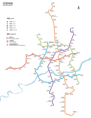
中文:沈阳地铁路线图 English: Geographically accurate map of Shenyang Metro |
| Date | See the file history |
| Source | Own work |
| Author | Painjet |
Licensing
[edit]
I, the copyright holder of this work, hereby publish it under the following license:
This file is licensed under the Creative Commons Attribution-Share Alike 4.0 International license.
- You are free:
- to share – to copy, distribute and transmit the work
- to remix – to adapt the work
- Under the following conditions:
- attribution – You must give appropriate credit, provide a link to the license, and indicate if changes were made. You may do so in any reasonable manner, but not in any way that suggests the licensor endorses you or your use.
- share alike – If you remix, transform, or build upon the material, you must distribute your contributions under the same or compatible license as the original.
File history
Click on a date/time to view the file as it appeared at that time.
| Date/Time | Thumbnail | Dimensions | User | Comment | |
|---|---|---|---|---|---|
| current | 10:04, 1 October 2023 | | 855 × 1,111 (1.25 MB) | Painjet (talk | contribs) | 优化 |
| 02:03, 29 September 2023 |  | 855 × 1,111 (1.24 MB) | Painjet (talk | contribs) | 2号线南延+4号线开通 | |
| 11:19, 12 March 2021 |  | 855 × 855 (1.27 MB) | Painjet (talk | contribs) | 皇姑屯 | |
| 05:33, 27 May 2020 |  | 855 × 855 (708 KB) | Painjet (talk | contribs) | . | |
| 07:19, 9 May 2020 |  | 855 × 855 (678 KB) | Painjet (talk | contribs) | . | |
| 15:03, 2 May 2020 |  | 855 × 855 (437 KB) | Painjet (talk | contribs) | 修改线路色 | |
| 17:58, 29 April 2020 |  | 855 × 855 (437 KB) | Painjet (talk | contribs) | 修正笔误 | |
| 16:11, 29 April 2020 |  | 855 × 855 (426 KB) | Painjet (talk | contribs) | Uploaded own work with UploadWizard |
You cannot overwrite this file.
File usage on Commons
The following 16 pages use this file:
- 辽宁
- User:Chumwa/OgreBot/Public transport information/2020 April 21-30
- User:Chumwa/OgreBot/Public transport information/2020 May 1-10
- User:Chumwa/OgreBot/Public transport information/2020 May 21-31
- User:Chumwa/OgreBot/Public transport information/2021 March 11-20
- User:Chumwa/OgreBot/Public transport information/2023 October 1-10
- User:Chumwa/OgreBot/Public transport information/2023 September 21-30
- User:Chumwa/OgreBot/Transport Maps/2020 April 21-30
- User:Chumwa/OgreBot/Transport Maps/2020 May 1-10
- User:Chumwa/OgreBot/Transport Maps/2020 May 21-31
- User:Chumwa/OgreBot/Transport Maps/2021 March 11-20
- User:Chumwa/OgreBot/Transport Maps/2023 October 1-10
- User:Chumwa/OgreBot/Transport Maps/2023 September 21-30
- User:Painjet
- Category:Maps of Shenyang Metro
- Category:Shenyang Metro
File usage on other wikis
The following other wikis use this file:
- Usage on de.wikivoyage.org
- Usage on en.wikipedia.org
- Usage on eo.wikipedia.org
- Usage on fr.wikipedia.org
- Usage on hu.wikipedia.org
- Usage on ja.wikipedia.org
- Usage on nl.wikipedia.org
- Usage on ru.wikipedia.org
- Usage on www.wikidata.org
- Usage on zh.wikipedia.org