File:Shenandoah Valley May-July 1864.png
Jump to navigation
Jump to search
Size of this preview: 491 × 599 pixels. Other resolutions: 197 × 240 pixels | 393 × 480 pixels | 629 × 768 pixels | 839 × 1,024 pixels | 1,679 × 2,048 pixels | 3,002 × 3,662 pixels.
Original file (3,002 × 3,662 pixels, file size: 6.1 MB, MIME type: image/png)
Captions
Captions
Add a one-line explanation of what this file represents
| Description |
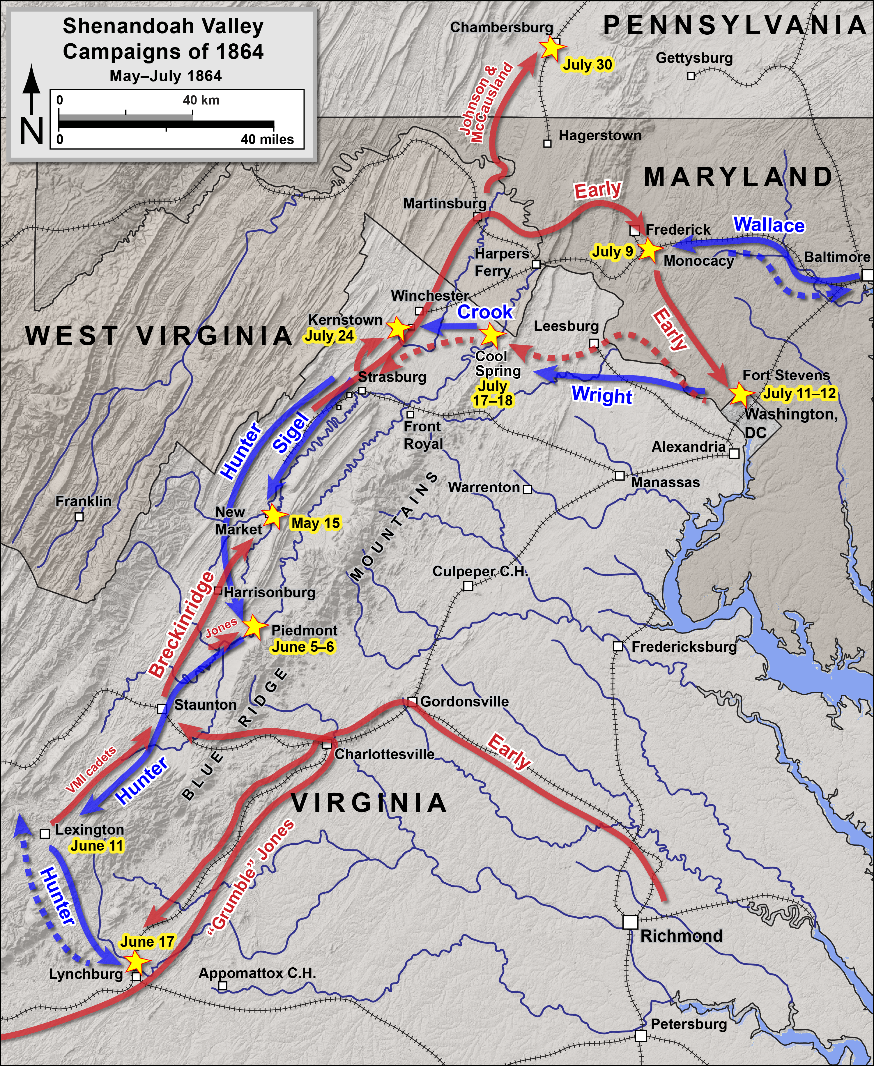
English: Map 1 of 2 of the Valley Campaigns of 1864 of the American Civil War. Drawn by Hal Jespersen in Adobe Illustrator CC. Graphic source file is available at http://cwmaps.com/
This file is licensed under the Creative Commons Attribution 3.0 Unported license. Attribution: Map by Hal Jespersen, www.cwmaps.com
|
| Date | |
| Source | Own work |
| Author | Hlj |
File history
Click on a date/time to view the file as it appeared at that time.
| Date/Time | Thumbnail | Dimensions | User | Comment | |
|---|---|---|---|---|---|
| current | 20:43, 5 March 2014 | | 3,002 × 3,662 (6.1 MB) | Hlj (talk | contribs) | Corrected route of Early from the Cold Harbor area, added Grumble Jones. Same license. |
| 23:14, 21 November 2013 |  | 1,600 × 1,952 (5.47 MB) | Hlj (talk | contribs) | Updated route of Lew Wallace. Same license. | |
| 23:11, 11 December 2011 |  | 1,501 × 1,831 (4.02 MB) | Hlj (talk | contribs) | {{Information |Description ={{en|1=Map 2 of 2 of the {{en|Map of the Valley Campaigns of 1864 of the American Civil War. Drawn by Hal Jespersen in Adobe Illustrator CS5. Graphic source file is |
You cannot overwrite this file.
File usage on Commons
There are no pages that use this file.
File usage on other wikis
The following other wikis use this file:
- Usage on es.wikipedia.org
- Usage on fr.wikipedia.org
- Usage on it.wikipedia.org
- Usage on nl.wikipedia.org
- Usage on pt.wikipedia.org
- Usage on vi.wikipedia.org