File:Shelby County Illinois Incorporated and Unincorporated areas Windsor Highlighted.svg
Jump to navigation
Jump to search

Size of this PNG preview of this SVG file: 502 × 292 pixels. Other resolutions: 320 × 186 pixels | 640 × 372 pixels | 1,024 × 596 pixels | 1,280 × 745 pixels | 2,560 × 1,489 pixels.
Original file (SVG file, nominally 502 × 292 pixels, file size: 401 KB)
Captions
Captions
Add a one-line explanation of what this file represents
Summary
[edit]
| Description |
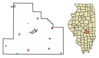
My own work, based on public domain information. Based on similar map concepts by w:User:Arkyan This map shows the incorporated and unincorporated areas in Mercer County, Illinois, highlighting Windsor in red. It was created from US Census Bureau data with the help of a custom fork of the kartography project, available on Github at |
| Source | Own work by the original uploader |
| Author | DemocraticLuntz |
Licensing
[edit]
github.com/jacobmas/kartograph.py
DemocraticLuntz at English Wikipedia, the copyright holder of this work, hereby publishes it under the following license:
If this file is eligible for relicensing, it may also be used under the Creative Commons Attribution-ShareAlike 3.0 license. The relicensing status of this image has not yet been reviewed. You can help.
|

|
Permission is granted to copy, distribute and/or modify this document under the terms of the GNU Free Documentation License, Version 1.2 or any later version published by the Free Software Foundation; with no Invariant Sections, no Front-Cover Texts, and no Back-Cover Texts. A copy of the license is included in the section entitled GNU Free Documentation License. Subject to disclaimers. |
Original upload log
[edit]
The original description page was here. All following user names refer to en.wikipedia.
| Date/Time | Dimensions | User | Comment |
|---|---|---|---|
| 2017-07-12 16:54:02 | 502 × 292 | DemocraticLuntz | |
| 2017-07-11 19:18:00 | 502 × 292 | DemocraticLuntz | |
| 2017-07-10 20:36:34 | 502 × 292 | DemocraticLuntz | |
| 2017-07-07 20:17:30 | 502 × 323 | DemocraticLuntz | |
| 2017-06-28 20:08:38 | 502 × 325 | DemocraticLuntz | Fixed software creating these |
| 2017-06-23 20:40:00 | 502 × 501 | DemocraticLuntz | My own work, based on public domain information. Based on similar map concepts by [[User:Arkyan]] This map shows the incorporated and unincorporated areas in Mercer County, Illinois, highlighting Windsor in red. It was created from US Census Bureau da... |
File history
Click on a date/time to view the file as it appeared at that time.
| Date/Time | Thumbnail | Dimensions | User | Comment | |
|---|---|---|---|---|---|
| current | 02:15, 26 October 2017 | | 502 × 292 (401 KB) | OgreBot (talk | contribs) | (BOT): Reverting to most recent version before archival |
| 02:15, 26 October 2017 |  | 502 × 292 (401 KB) | OgreBot (talk | contribs) | (BOT): Uploading old version of file from en.wikipedia; originally uploaded on 2017-07-11 19:18:00 by DemocraticLuntz | |
| 02:15, 26 October 2017 |  | 502 × 292 (400 KB) | OgreBot (talk | contribs) | (BOT): Uploading old version of file from en.wikipedia; originally uploaded on 2017-07-10 20:36:34 by DemocraticLuntz | |
| 02:15, 26 October 2017 |  | 502 × 323 (401 KB) | OgreBot (talk | contribs) | (BOT): Uploading old version of file from en.wikipedia; originally uploaded on 2017-07-07 20:17:30 by DemocraticLuntz | |
| 02:15, 26 October 2017 |  | 502 × 325 (403 KB) | OgreBot (talk | contribs) | (BOT): Uploading old version of file from en.wikipedia; originally uploaded on 2017-06-28 20:08:38 by DemocraticLuntz | |
| 02:15, 26 October 2017 |  | 502 × 501 (408 KB) | OgreBot (talk | contribs) | (BOT): Uploading old version of file from en.wikipedia; originally uploaded on 2017-06-23 20:40:00 by DemocraticLuntz | |
| 22:00, 24 October 2017 |  | 502 × 292 (401 KB) | FSock (talk | contribs) | Transferred from en.wikipedia (MTC!) (1.1.1) |
You cannot overwrite this file.
File usage on Commons
There are no pages that use this file.
File usage on other wikis
The following other wikis use this file:
- Usage on ar.wikipedia.org
- Usage on arz.wikipedia.org
- Usage on azb.wikipedia.org
- Usage on ca.wikipedia.org
- Usage on en.wikipedia.org
- Usage on eu.wikipedia.org
- Usage on fr.wikipedia.org
- Usage on ht.wikipedia.org
- Usage on sv.wikipedia.org
- Usage on tt.wikipedia.org
- Usage on ur.wikipedia.org
- Usage on vi.wikipedia.org
- Usage on www.wikidata.org
- Usage on zh.wikipedia.org