File:Sheffield Victoria railway station (site), 1983 (geograph 4287223).jpg
Jump to navigation
Jump to search
No higher resolution available.
Sheffield_Victoria_railway_station_(site),_1983_(geograph_4287223).jpg (635 × 414 pixels, file size: 38 KB, MIME type: image/jpeg)
Captions
Captions
Add a one-line explanation of what this file represents
Summary
[edit],_1983_(geograph_4287223).jpg&action=edit§ion=1)
| Description |
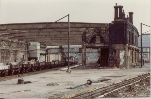
English: Sheffield Victoria railway station (site), 1983 Opened in 1851 by the Manchester Sheffield & Lincolnshire Railway, later the Great Central Railway on the line from Manchester London Road via Woodhead to London Marylebone, this station closed in 1970. View south east towards Darnall and Retford at the time the station was being dismantled. |
| Date | |
| Source | From geograph.org.uk |
| Author | Nigel Thompson |
| Permission (Reusing this file) |
Creative Commons Attribution Share-alike license 2.0 |
| Attribution (required by the license) | Nigel Thompson / Sheffield Victoria railway station (site), 1983 / |
| Camera location | | View this and other nearby images on: OpenStreetMap |
|---|
,_1983_(geograph_4287223).jpg¶ms=053.387888_N_-001.459583_E_globe:Earth_type:camera_source:geograph-osgb36(SK36048803)_heading:112.00&language=en)
| Object location | | View this and other nearby images on: OpenStreetMap |
|---|
,_1983_(geograph_4287223).jpg¶ms=053.387700_N_-001.458830_E_globe:Earth_class:object_type:object_source:geograph-osgb36(SK36098801)_heading:112.00&language=en)
Licensing
[edit],_1983_(geograph_4287223).jpg&action=edit§ion=2)

|
This image was taken from the Geograph project collection. See this photograph's page on the Geograph website for the photographer's contact details. The copyright on this image is owned by Nigel Thompson and is licensed for reuse under the Creative Commons Attribution-ShareAlike 2.0 license.
|
This file is licensed under the Creative Commons Attribution-Share Alike 2.0 Generic license.
Attribution: Nigel Thompson
- You are free:
- to share – to copy, distribute and transmit the work
- to remix – to adapt the work
- Under the following conditions:
- attribution – You must give appropriate credit, provide a link to the license, and indicate if changes were made. You may do so in any reasonable manner, but not in any way that suggests the licensor endorses you or your use.
- share alike – If you remix, transform, or build upon the material, you must distribute your contributions under the same or compatible license as the original.
File history
Click on a date/time to view the file as it appeared at that time.
| Date/Time | Thumbnail | Dimensions | User | Comment | |
|---|---|---|---|---|---|
| current | 19:45, 29 December 2019 | | 635 × 414 (38 KB) | Lamberhurst (talk | contribs) | Transferred from geograph.co.uk using [https://tools.wmflabs.org/geograph2commons/ geograph2commons] |
You cannot overwrite this file.
File usage on Commons
The following page uses this file:
,_1983_(geograph_4287223).jpg&oldid=594618386)