File:Shanghai, China ESA396534.jpg
Original file (4,653 × 4,091 pixels, file size: 18.41 MB, MIME type: image/jpeg)
Captions
Captions
Summary
[edit]| Description |
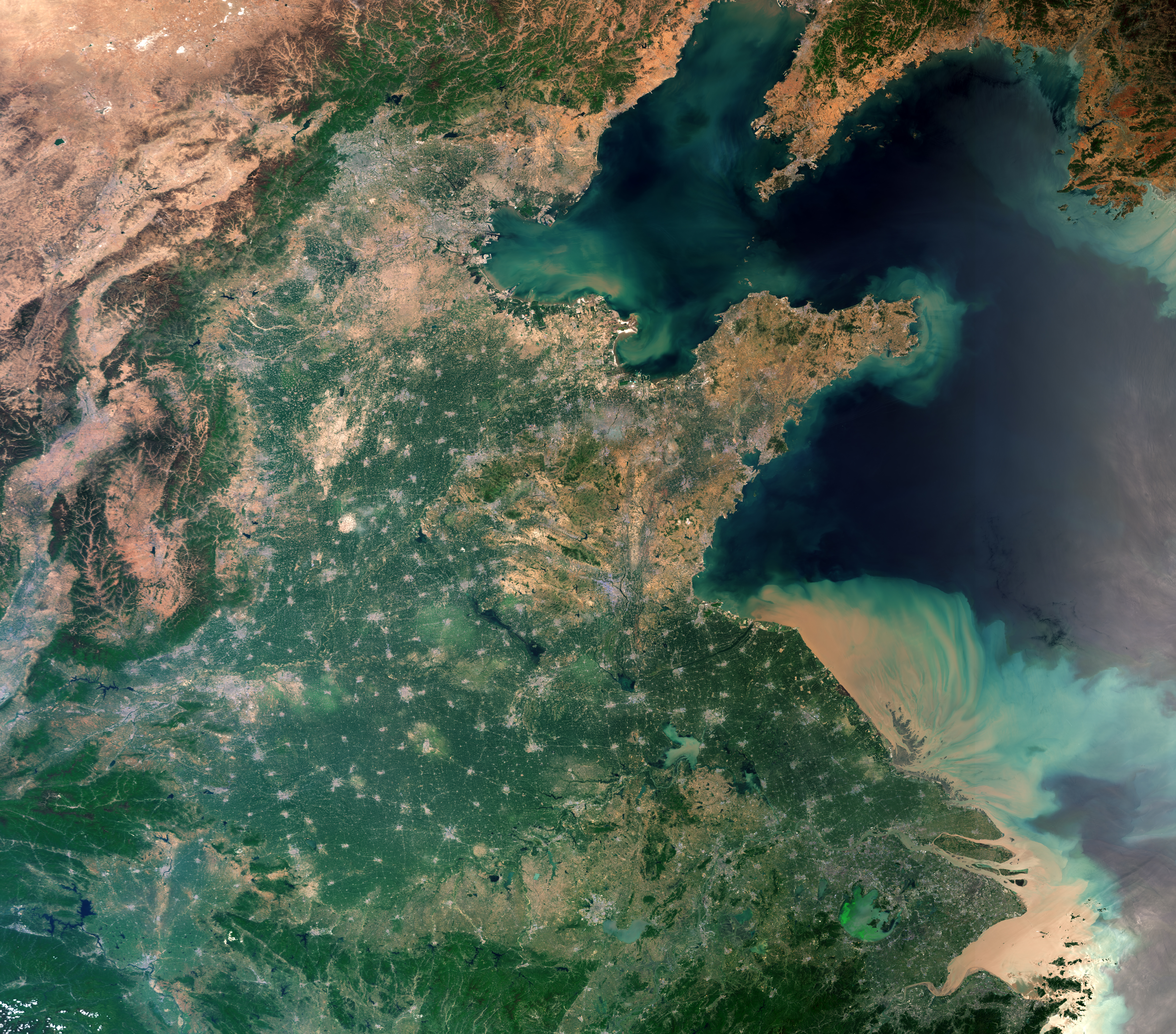
English: The Copernicus Sentinel-3A satellite takes us over Shanghai, China. One of the most populous cities in the world and home to over 24 million people, the city is visible in the lower right of the image just above the Yangtze River mouth. As a significant global financial centre it is also the site of the world’s busiest container ports because of its strategic location on the Yangtze River delta.
The image covers an area of over 1200 km, showing Beijing at the centre-top, the salt flats close to the Mongolian border in the top left, and North Korea, with its capital, Pyongyang, just visible in the top right of the image. A large number of urban settlements represented as grey flecks are interspersed with agricultural fields, dominating the central part of the image. This true colour image taken using Sentinel-3A’s Ocean and Land Colour Instrument (OLCI) shows the huge amount of sediment carried into the ocean along the coast. Meanwhile, Taihu Lake is shown in green in the lower right part of the image. In 2007, an algal bloom on the lake caused major problems with water supplies in the neighbouring city of Wuxi. Such algal blooms may well be linked to the discharge of phosphates found in fertilizers used in industry and agriculture into the water. Steps have been taken to limit the use of such fertilisers in a bid to reduce algal blooms, which can significantly alter the ecology of the environment below the surface and pose a threat to various forms of water life. Sentinel-3 is a two-satellite mission to supply the coverage and data delivery needed for Europe’s Copernicus environmental monitoring programme. Since 2016, Sentinel-3A has been measuring our oceans, land, ice and atmosphere to monitor and understand large-scale global dynamics and to provide critical information for marine operations, and more. This image, which was captured on 29 April 2017, is also featured on theEarth from Space video programme. |
| Date | |
| Source | http://www.esa.int/spaceinimages/Images/2018/07/Shanghai_China |
| Author | European Space Agency |
| Permission (Reusing this file) |
contains modified Copernicus Sentinel data (2017), processed by ESA ,CC BY-SA 3.0 IGO |
| Other versions |
|
| Title | Shanghai, China |
| System | Copernicus |
| Set | Earth observation image of the week |
| Mission | Sentinel-3 |
| Activity | Observing the Earth |
Licensing
[edit]
- You are free:
- to share – to copy, distribute and transmit the work
- to remix – to adapt the work
- Under the following conditions:
- attribution – You must give appropriate credit, provide a link to the license, and indicate if changes were made. You may do so in any reasonable manner, but not in any way that suggests the licensor endorses you or your use.
- share alike – If you remix, transform, or build upon the material, you must distribute your contributions under the same or compatible license as the original.

|
This image contains data from a satellite in the Copernicus Programme, such as Sentinel-1, Sentinel-2 or Sentinel-3. Attribution is required when using this image.
Attribution: Contains modified Copernicus Sentinel data {{{year}}}
The use of Copernicus Sentinel Data is regulated under EU law (Commission Delegated Regulation (EU) No 1159/2013 and Regulation (EU) No 377/2014). Relevant excerpts:
Free access shall be given to GMES dedicated data [...] made available through GMES dissemination platforms [...].
Access to GMES dedicated data [...] shall be given for the purpose of the following use in so far as it is lawful:
GMES dedicated data [...] may be used worldwide without limitations in time.
GMES dedicated data and GMES service information are provided to users without any express or implied warranty, including as regards quality and suitability for any purpose. |
File history
Click on a date/time to view the file as it appeared at that time.
| Date/Time | Thumbnail | Dimensions | User | Comment | |
|---|---|---|---|---|---|
| current | 09:13, 13 September 2018 | | 4,653 × 4,091 (18.41 MB) | Fæ (talk | contribs) | European Space Agency, Id 396534, http://www.esa.int/spaceinimages/Images/2018/07/Shanghai_China, User:Fæ/Project_list/ESA |
You cannot overwrite this file.
File usage on Commons
The following 2 pages use this file: