File:Shakemap Intensity of the 2015 South Kivu Earthquake.jpg
Jump to navigation
Jump to search
Size of this preview: 512 × 600 pixels. Other resolutions: 205 × 240 pixels | 612 × 717 pixels.
Original file (612 × 717 pixels, file size: 151 KB, MIME type: image/jpeg)
Captions
Captions
Add a one-line explanation of what this file represents

|
This file was moved to Wikimedia Commons from en.wikipedia using a bot script. All source information is still present. It requires review. Additionally, there may be errors in any or all of the information fields; information on this file should not be considered reliable and the file should not be used until it has been reviewed and any needed corrections have been made. Once the review has been completed, this template should be removed. For details about this file, see below. Check now! |
Summary
[edit]
| Description | |
| Date | |
| Source | https://earthquake.usgs.gov/earthquakes/eventpage/us10002zzn#shakemap |
| Author | USGS |
Licensing
[edit]
This image is in the public domain in the United States because it only contains materials that originally came from the United States Geological Survey, an agency of the United States Department of the Interior. For more information, see the official USGS copyright policy.
|
Original upload log
[edit]
The original description page was here. All following user names refer to en.wikipedia.
| Date/Time | Dimensions | User | Comment |
|---|---|---|---|
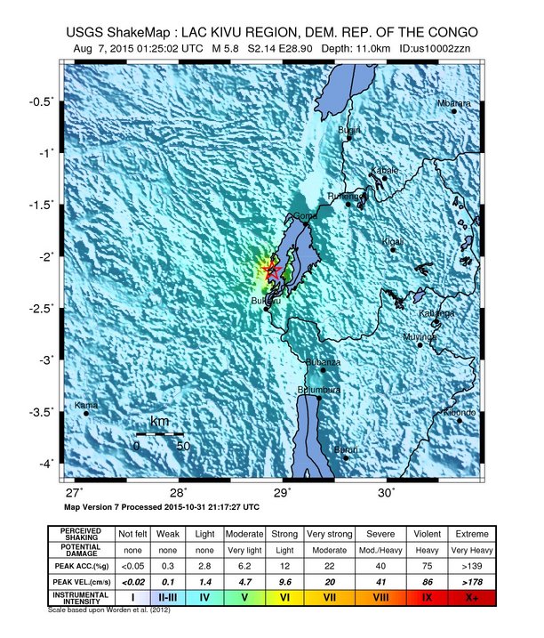
| 2017-07-15 06:25 | 612×717× (154845 bytes) | AlphaBetaGamma01 | =={{int:filedesc}}== {{Information |description={{en|1=USGS Intensity map for the August 7, 2015 earthquake in the Kivu region of the Democratic Republic of the Congo.}} |date=2015-08-07 |source=http://earthquake.usgs.gov/earthquakes/eventpage/us10002z... |
File history
Click on a date/time to view the file as it appeared at that time.
| Date/Time | Thumbnail | Dimensions | User | Comment | |
|---|---|---|---|---|---|
| current | 01:30, 17 July 2017 | | 612 × 717 (151 KB) | Daylen (talk | contribs) | Transferred from en.wikipedia |
You cannot overwrite this file.
File usage on Commons
There are no pages that use this file.
File usage on other wikis
The following other wikis use this file:
- Usage on en.wikipedia.org
- Usage on vi.wikipedia.org
- Usage on zh.wikipedia.org