File:ShakeAlert - example.jpg
Jump to navigation
Jump to search

Size of this preview: 266 × 598 pixels. Other resolutions: 107 × 240 pixels | 213 × 480 pixels | 735 × 1,652 pixels.
Original file (735 × 1,652 pixels, file size: 894 KB, MIME type: image/jpeg)
Captions
Captions
Add a one-line explanation of what this file represents
Summary
[edit]
| Description |
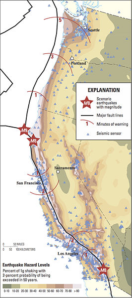
English: Map of the United States West Coast showing the amount of advance warning time that might be available from a system like ShakeAlert for several plausible future earthquake scenarios. Those scenarios include magnitude 8 (M8) quakes on the
San Andreas Fault with epicenters in northern and southern California and an M9 quake on the Cascadia subduction zone with an epicenter offshore of northernmost California. |
| Date | |
| Source | ShakeAlert—An Earthquake Early Warning System for the United States West Coast |
| Author | Erin R. Burkett, Douglas D. Given, and Lucile M. Jones |
Licensing
[edit]
This work is in the public domain in the United States because it is a work prepared by an officer or employee of the United States Government as part of that person’s official duties under the terms of Title 17, Chapter 1, Section 105 of the US Code.
Note: This only applies to original works of the Federal Government and not to the work of any individual U.S. state, territory, commonwealth, county, municipality, or any other subdivision. This template also does not apply to postage stamp designs published by the United States Postal Service since 1978. (See § 313.6(C)(1) of Compendium of U.S. Copyright Office Practices). It also does not apply to certain US coins; see The US Mint Terms of Use.
|
 | |
| This file has been identified as being free of known restrictions under copyright law, including all related and neighboring rights. | ||
File history
Click on a date/time to view the file as it appeared at that time.
| Date/Time | Thumbnail | Dimensions | User | Comment | |
|---|---|---|---|---|---|
| current | 05:22, 25 August 2015 | | 735 × 1,652 (894 KB) | DarTar (talk | contribs) | User created page with UploadWizard |
You cannot overwrite this file.
File usage on Commons
There are no pages that use this file.
File usage on other wikis
The following other wikis use this file:
- Usage on en.wikipedia.org
- Usage on ja.wikipedia.org