File:Sgurr a' Choire Bhig and the Cuillin ridge - geograph.org.uk - 1719445.jpg
Jump to navigation
Jump to search
No higher resolution available.
Sgurr_a'_Choire_Bhig_and_the_Cuillin_ridge_-_geograph.org.uk_-_1719445.jpg (640 × 427 pixels, file size: 90 KB, MIME type: image/jpeg)
Captions
Captions
Add a one-line explanation of what this file represents
Summary
[edit]| Description |
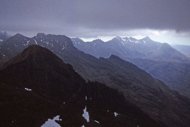
English: Sgurr a' Choire Bhig and the Cuillin ridge View from Gars-bheinn at the south end of the Cuillin ridge under threatening skies.
Sgurr a' Choire Bhig is in the foreground. Beyond that are Sgurr Dubh na Da Bheinn, Sgurr Dubh Mor (NG4520) and the ridge up from Loch Coruisk in profile. In the distance, is the north end of the Cuillin ridge with Sgurr nan Gillean (NG4725) on the right. |
| Date | |
| Source | From geograph.org.uk |
| Author | Ian Taylor |
| Attribution (required by the license) | Ian Taylor / Sgurr a' Choire Bhig and the Cuillin ridge / |
| Camera location | | View this and other nearby images on: OpenStreetMap |
|---|
| Object location | | View this and other nearby images on: OpenStreetMap |
|---|
Licensing
[edit]
|
This image was taken from the Geograph project collection. See this photograph's page on the Geograph website for the photographer's contact details. The copyright on this image is owned by Ian Taylor and is licensed for reuse under the Creative Commons Attribution-ShareAlike 2.0 license.
|
This file is licensed under the Creative Commons Attribution-Share Alike 2.0 Generic license.
Attribution: Ian Taylor
- You are free:
- to share – to copy, distribute and transmit the work
- to remix – to adapt the work
- Under the following conditions:
- attribution – You must give appropriate credit, provide a link to the license, and indicate if changes were made. You may do so in any reasonable manner, but not in any way that suggests the licensor endorses you or your use.
- share alike – If you remix, transform, or build upon the material, you must distribute your contributions under the same or compatible license as the original.

_heading:337.00&language=en)
_heading:337.00&language=en)
File history
Click on a date/time to view the file as it appeared at that time.
| Date/Time | Thumbnail | Dimensions | User | Comment | |
|---|---|---|---|---|---|
| current | 09:17, 5 March 2011 | | 640 × 427 (90 KB) | GeographBot (talk | contribs) | == {{int:filedesc}} == {{Information |description={{en|1=Sgurr a' Choire Bhig and the Cuillin ridge View from Gars-bheinn at the south end of the Cuillin ridge under threatening skies. Sgurr a' Choire Bhig is in the foreground. Beyond that are Sgurr Dubh |
You cannot overwrite this file.
File usage on Commons
There are no pages that use this file.
File usage on other wikis
The following other wikis use this file:
- Usage on de.wikipedia.org