File:Severe Heatwave in South America in October 2020.jpg
Original file (3,535 × 2,567 pixels, file size: 4.96 MB, MIME type: image/jpeg)
Captions
Captions
Summary
[edit]
| Description |
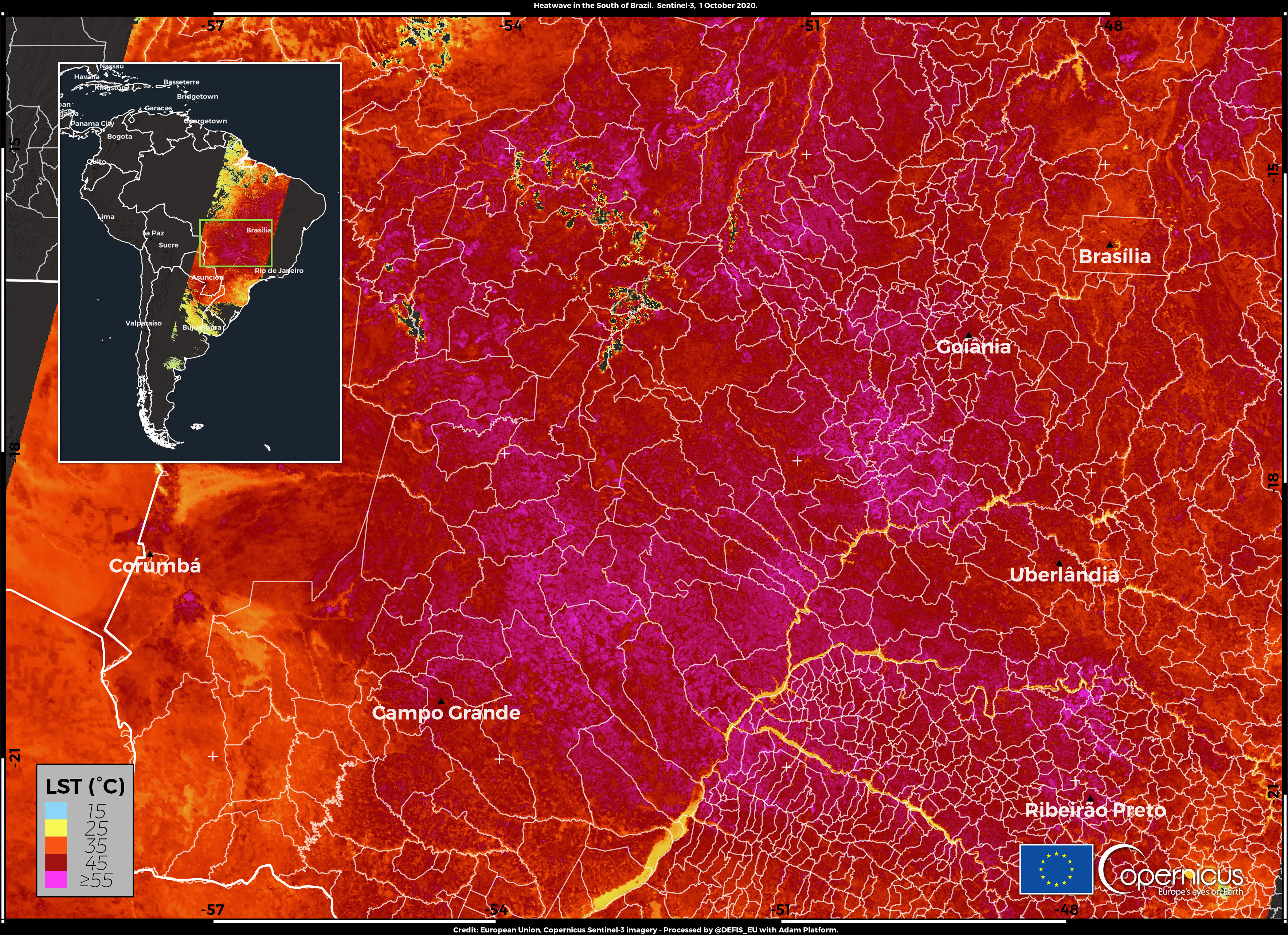
English: A severe heatwave is currently affecting South America, and several temperature records have been beaten in the first two weeks of the local spring. Extreme temperatures have been recorded in several countries in the past few days. The city of Pozo Hondo in Paraguay has recorded an all-time maximum of 45.5°C on 26 September, beating the old 45°C record. Argentina’s all-time record for September has been beaten in the city of Resistencia with a temperature of 43.5°C. But the most affected country is Brazil, which had already been hit by a heatwave in the first two weeks of September. In the last days of the month, a new September national record was set with 44.1°C on 30 September. October started with the new highest value for the maximum temperature of the month, registered in the city of Corumba with 43.4°C. Other records have been beaten across the country. But all these values could be exceeded again in the next few days because the heatwave is still ongoing and new records can be expected, according to weather forecasts. This image is a Land Surface Temperature map with values retrieved from the Sentinel-3 data that have been acquired on 1 October 2020 over central and southern Brazil and shows that in many areas the soil temperature reaches the 55°C marker or exceeds it. The Copernicus Sentinel-3 mission is composed by two twin satellites (Sentinel-3A and Sentinel-3B) that are equipped with the Sea Land Surface Temperature Radiometer instrument (SLSTR) allowing to determine the Land Surface Temperature (LST) thanks to the data collected by its thermal. The Land Surface Temperature is an important parameter to monitor glaciers, ice sheets, permafrost and the vegetation in the Earth's ecosystems. Land surface temperature maps are also used for commercial agricultural purposes to evaluate irrigation requirements during summer periods when crops may be exposed to heat stress or, in contrast, during winter periods, when crops and trees may be exposed to damaging frost. |
| Date | 2 October 2020 (upload date) |
| Source | Severe Heatwave in South America in October 2020 |
| Author | European Union , Copernicus Sentinel-3 imagery |
Licensing
[edit]

|
This image contains data from a satellite in the Copernicus Programme, such as Sentinel-1, Sentinel-2 or Sentinel-3. Attribution is required when using this image.
Attribution: Contains modified Copernicus Sentinel data 2020
The use of Copernicus Sentinel Data is regulated under EU law (Commission Delegated Regulation (EU) No 1159/2013 and Regulation (EU) No 377/2014). Relevant excerpts:
Free access shall be given to GMES dedicated data [...] made available through GMES dissemination platforms [...].
Access to GMES dedicated data [...] shall be given for the purpose of the following use in so far as it is lawful:
GMES dedicated data [...] may be used worldwide without limitations in time.
GMES dedicated data and GMES service information are provided to users without any express or implied warranty, including as regards quality and suitability for any purpose. |
File history
Click on a date/time to view the file as it appeared at that time.
| Date/Time | Thumbnail | Dimensions | User | Comment | |
|---|---|---|---|---|---|
| current | 12:18, 1 August 2023 | | 3,535 × 2,567 (4.96 MB) | OptimusPrimeBot (talk | contribs) | #Spacemedia - Upload of https://www.copernicus.eu/system/files/2020-10/image_day/Brazil_credit_row.jpg via Commons:Spacemedia |
You cannot overwrite this file.
File usage on Commons
There are no pages that use this file.