File:Severe Cyclonic Storm Biparjoy Nears Landfall (MODIS).jpg

Original file (5,856 × 4,594 pixels, file size: 3.14 MB, MIME type: image/jpeg)
Captions
Captions
Summary
[edit].jpg&action=edit§ion=1)
| Description |
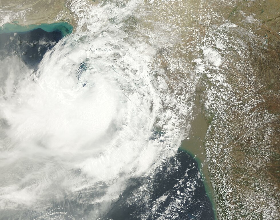
English: After stirring in the Arabian Sea for over a week, Severe Cyclonic Storm Biparjoy made landfall near Nalyia, in the state of Gujarat, India by 1800 UTC (2:00 p.m. EDT) on June 15, 2023. According to the Joint Typhoon Warning Center (JWTC), maximum sustained winds near the time of landfall measured approximately 64 mph (103 km/h).
Biparjoy developed into a cyclone in the early morning hours of June 6 and spent eight days in the Arabian Sea, generally moving slowly north, until it took a turn to the east to take aim at Pakistan and India. The long-lived cyclone had wind speeds of 129 kilometers (80 miles) per hour on June 14, making it a Category 1 storm on the Saffir-Simpson Wind Scale. At that time, the outer bands of the storm were lashing both countries as the storm approached. Fortunately, Cyclone Biparjoy weakened before striking India. Early reports of damage include uprooted trees, pelting rain, and flooding in parts of coastal India and Pakistan. Multiple deaths have been reported, including drownings off the coast of Mumbai. At 1800 UTC (2:00 p.m. EDT) on June 15, the JTWC issued its last advisory on Tropical Cyclone Biparjoy. They forecast that the system would continue to track inland over the next 36 hours, slowly weakening through June 15 then rapidly weakening followed by dissipation as it moves over rugged and dry terrain. The Moderate Resolution Imaging Spectroradiometer (MODIS) on board NASA’s Terra satellite acquired a true-color image of Severe Cyclonic Storm Biparjoy approaching landfall on the morning of June 15. The somewhat ragged eye appears to be sitting over the Arabian Sea about 90 miles (150 km) southwest of the coast of Gujarat, India. Convective bands that carry both torrential rain and high wind stretch well over both India (east) and low-lying areas of Pakistan (west). |
||
| Date | Taken on 15 June 2023 | ||
| Source |
Severe Cyclonic Storm Biparjoy Nears Landfall (direct link)
|
||
| Author | MODIS Land Rapid Response Team, NASA GSFC |
| This media is a product of the Terra mission Credit and attribution belongs to the mission team, if not already specified in the "author" row |
Licensing
[edit].jpg&action=edit§ion=2)
| This file is in the public domain in the United States because it was solely created by NASA. NASA copyright policy states that "NASA material is not protected by copyright unless noted". (See Template:PD-USGov, NASA copyright policy page or JPL Image Use Policy.) | ||
 |
Warnings:
|
File history
Click on a date/time to view the file as it appeared at that time.
| Date/Time | Thumbnail | Dimensions | User | Comment | |
|---|---|---|---|---|---|
| current | 18:54, 31 July 2023 | | 5,856 × 4,594 (3.14 MB) | OptimusPrimeBot (talk | contribs) | #Spacemedia - Upload of http://modis.gsfc.nasa.gov/gallery/images/image06162023_250m.jpg via Commons:Spacemedia |
You cannot overwrite this file.
File usage on Commons
There are no pages that use this file.
.jpg&oldid=792462622)