File:Seseo-ceceo-distinción en el español.png
Jump to navigation
Jump to search

Size of this preview: 451 × 599 pixels. Other resolutions: 181 × 240 pixels | 361 × 480 pixels | 694 × 922 pixels.
Original file (694 × 922 pixels, file size: 28 KB, MIME type: image/png)
Captions
Captions
Add a one-line explanation of what this file represents

|
This map image could be re-created using vector graphics as an SVG file. This has several advantages; see Commons:Media for cleanup for more information. If an SVG form of this image is available, please upload it and afterwards replace this template with
{{vector version available|new image name}}.
It is recommended to name the SVG file “Seseo-ceceo-distinción en el español.svg”—then the template Vector version available (or Vva) does not need the new image name parameter. |
Summary
[edit]
| Description |
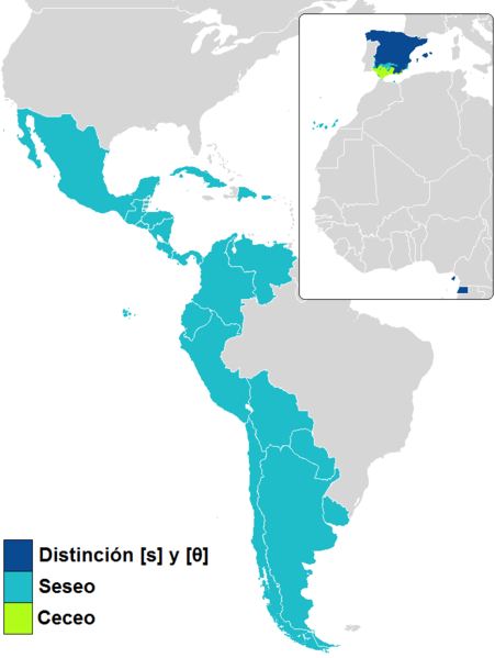
English: Map of seseo, ceceo and /θ/–/s/ distinction in Spanish
Español: Mapa del seseo, ceceo y distinción en el español |
| Date | |
| Source |
Own work http://cvc.cervantes.es/lengua/anuario/anuario_06-07/pdf/paises_08.pdf |
| Author | Fobos92 |
Licensing
[edit]
I, the copyright holder of this work, hereby publish it under the following license:
This file is licensed under the Creative Commons Attribution-Share Alike 4.0 International license.
- You are free:
- to share – to copy, distribute and transmit the work
- to remix – to adapt the work
- Under the following conditions:
- attribution – You must give appropriate credit, provide a link to the license, and indicate if changes were made. You may do so in any reasonable manner, but not in any way that suggests the licensor endorses you or your use.
- share alike – If you remix, transform, or build upon the material, you must distribute your contributions under the same or compatible license as the original.
File history
Click on a date/time to view the file as it appeared at that time.
| Date/Time | Thumbnail | Dimensions | User | Comment | |
|---|---|---|---|---|---|
| current | 22:01, 15 April 2023 | | 694 × 922 (28 KB) | Moalli (talk | contribs) | Reverted to version as of 10:45, 3 April 2022 (UTC) Per discussion with admins to reflect source/actual widespread usage of language |
| 01:18, 9 February 2023 |  | 694 × 922 (48 KB) | Makisig Villegas Chua (talk | contribs) | On the same note, Saharan Spanish should be readded as well. Presently, it might even be more prevalent in Western Sahara than Philippine Spanish in the Philippines. | |
| 12:04, 27 January 2023 |  | 694 × 922 (29 KB) | Sky Harbor (talk | contribs) | Again, what is it with people insisting that Spanish is "dead" in the Philippines when people still speak it? Anyway, Philippine Spanish is a seseante variety; distinción is taught but is not standard in this variety | |
| 10:45, 3 April 2022 |  | 694 × 922 (28 KB) | Hanzlan (talk | contribs) | minor changes | |
| 17:36, 28 March 2018 |  | 694 × 922 (28 KB) | Maphobbyist (talk | contribs) | Update | |
| 17:31, 7 August 2015 |  | 694 × 922 (32 KB) | Fobos92 (talk | contribs) | Andorra | |
| 17:29, 7 August 2015 |  | 694 × 922 (32 KB) | Fobos92 (talk | contribs) | User created page with UploadWizard |
You cannot overwrite this file.
File usage on Commons
The following 5 pages use this file:
- User:Chumwa/OgreBot/Travel and communication maps/2018 March 21-31
- User:Chumwa/OgreBot/Travel and communication maps/2022 April 1-10
- User:Chumwa/OgreBot/Travel and communication maps/2023 April 11-20
- User:Chumwa/OgreBot/Travel and communication maps/2023 February 1-9
- User:Chumwa/OgreBot/Travel and communication maps/2023 January 21-31
File usage on other wikis
The following other wikis use this file:
- Usage on ast.wikipedia.org
- Usage on ca.wikipedia.org
- Usage on en.wikipedia.org
- Usage on es.wikipedia.org
- Usage on es.wiktionary.org
- Usage on www.wikidata.org