File:Serbian chapel on Kajmakčalan (2521m).jpg
Jump to navigation
Jump to search

Size of this preview: 800 × 600 pixels. Other resolutions: 320 × 240 pixels | 640 × 480 pixels | 1,024 × 768 pixels | 1,280 × 960 pixels | 2,560 × 1,920 pixels | 4,608 × 3,456 pixels.
Original file (4,608 × 3,456 pixels, file size: 7.74 MB, MIME type: image/jpeg)
Captions
Captions
Add a one-line explanation of what this file represents
Summary
[edit].jpg&action=edit§ion=1)
| Description |
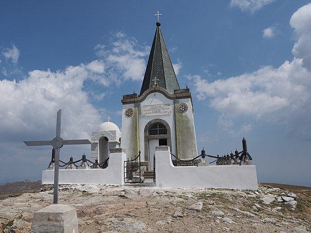
Български: Сръбски параклис на Каймакчалан. English: Serbian chapel to fallen soldiers on Kajmakčalan peak - 2521 m, place of fierce figthing in autumn of 1916. Peak was most important point in Macedonian front in 1st WW where in 1918 Serbian-French troops made biggest breakthrough which forced Bulgaria to capitulate. After entire Balkan front collapsed, Austro-Hungaria and Turkey (which was cut off from German railway supplies) capitulated too. Relicts of fierce figthing can be seen even today, bones, bullets, grenades, bunkers and trenches. Some 40 meters below the chapel is a morgue with skulls and bones found on the mountain. Српски / srpski: Spomen kapela palim borcima na Kajmakčalanu iz prvog svetskog rata - solunski front. Македонски: Спомен капела на српски војници от првата светска војна на врвот на Кајмакчалан. Slovenščina: Spominska kapela srbskim vojakom padlim pri osvajanju Kajmakčalana v prvi svetovni vojni na vrhu Kajmakčalana 2521 m, makedonsko-grška meja. Français : Chapelle serbe dédiée aux soldats tombés au pic Kajmakčalan (2521 m), lieu de combats acharnés à l'automne 1916. Ce sommet était un point important du front de Macédoine durant la Grande Guerre, d'où en 1918 les troupes franco-serbes lancèrent une grande offensive qui força la Bulgarie à capituler. Après quoi, le front des Balkans s'effondra, l'Autriche-Hongrie et l'Empire ottoman (dont la liaison ferroviaire avec les ressources allemandes étaient coupées) capitulèrent aussi. Aujourd'hui on voit encore des restes de cette bataille : ossements, obus, grenades, bunkers et tranchées. À une quarantaine de mètres en contrebas de la chapelle se trouve un ossuaire où sont recueillis les ossements trouvés dans la montagne. |
| Date | |
| Source | Own work |
| Author | Petar Milošević |
| Permission (Reusing this file) |
Petar Milošević (author) |
| Camera location | | View this and other nearby images on: OpenStreetMap |
|---|
.jpg¶ms=040.930556_N_0021.786111_E_globe:Earth_type:camera__&language=en)
Licensing
[edit].jpg&action=edit§ion=2)
I, the copyright holder of this work, hereby publish it under the following license:
This file is licensed under the Creative Commons Attribution-Share Alike 4.0 International license.
- You are free:
- to share – to copy, distribute and transmit the work
- to remix – to adapt the work
- Under the following conditions:
- attribution – You must give appropriate credit, provide a link to the license, and indicate if changes were made. You may do so in any reasonable manner, but not in any way that suggests the licensor endorses you or your use.
- share alike – If you remix, transform, or build upon the material, you must distribute your contributions under the same or compatible license as the original.
File history
Click on a date/time to view the file as it appeared at that time.
| Date/Time | Thumbnail | Dimensions | User | Comment | |
|---|---|---|---|---|---|
| current | 05:38, 21 August 2017 | | 4,608 × 3,456 (7.74 MB) | PetarM (talk | contribs) | User created page with UploadWizard |
You cannot overwrite this file.
File usage on Commons
The following 2 pages use this file:
File usage on other wikis
The following other wikis use this file:
- Usage on be-tarask.wikipedia.org
- Usage on be.wikipedia.org
- Usage on bg.wikipedia.org
- Usage on en.wikipedia.org
- Usage on en.wikivoyage.org
- Usage on mk.wikipedia.org
- Usage on pl.wikipedia.org
- Usage on pl.wikivoyage.org
- Usage on pt.wikipedia.org
- Usage on ru.wikipedia.org
- Usage on ru.wikivoyage.org
- Usage on sr.wikipedia.org
- Usage on www.wikidata.org
.jpg&oldid=776174885)