File:Sepat 2019 track.png
Jump to navigation
Jump to search

Size of this preview: 737 × 599 pixels. Other resolutions: 295 × 240 pixels | 590 × 480 pixels | 944 × 768 pixels | 1,259 × 1,024 pixels | 2,518 × 2,048 pixels | 2,700 × 2,196 pixels.
Original file (2,700 × 2,196 pixels, file size: 2.69 MB, MIME type: image/png)
Captions
Captions
Add a one-line explanation of what this file represents
Summary
| Description |
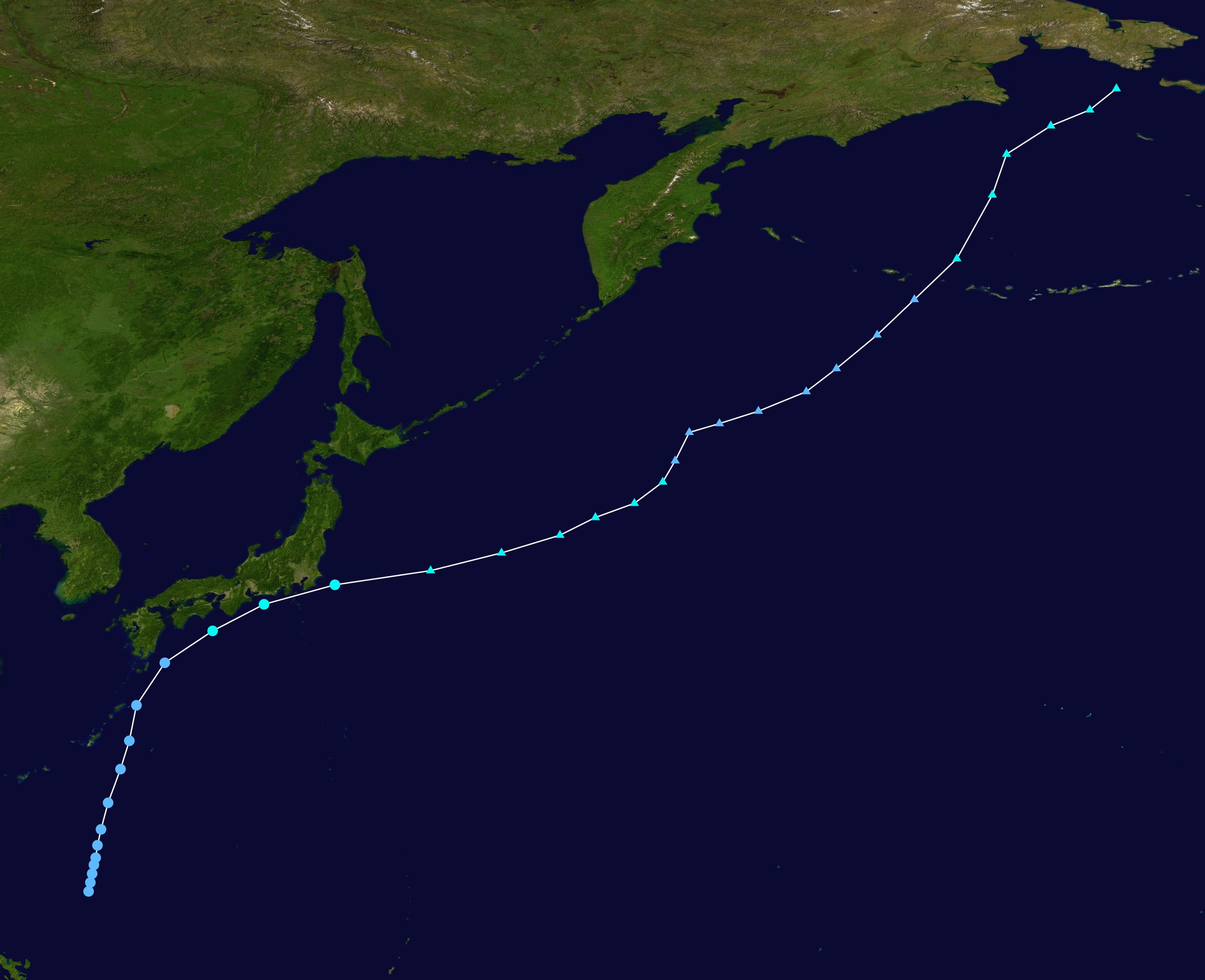
English: Track map of Tropical Storm Sepat of the 2019 Pacific typhoon season. The points show the location of the storm at 6-hour intervals. The colour represents the storm's maximum sustained wind speeds as classified in the (see below), and the shape of the data points represent the nature of the storm, according to the legend below. Tropical depression (≤38 mph, ≤62 km/h)
Tropical storm (39–73 mph, 63–118 km/h)
Category 1 (74–95 mph, 119–153 km/h)
Category 2 (96–110 mph, 154–177 km/h)
Category 3 (111–129 mph, 178–208 km/h)
Category 4 (130–156 mph, 209–251 km/h)
Category 5 (≥157 mph, ≥252 km/h)
Unknown
Storm type |
||
| Date | 2019-06-24–2019-07-03 | ||
| Source | Created by Meow using Wikipedia:WikiProject Tropical cyclones/Tracks. The background image is from NASA. Tracking data is from the Japan Meteorological Agency[1]. | ||
| Author | Meow | ||
| Source code | Track map data table, if present below, is in HURDAT2 or ATCF format. See format details in [2] and [3], respectively.
|
Licensing
[edit]| This work has been released into the public domain by its author, Meow. This applies worldwide. In some countries this may not be legally possible; if so: Meow grants anyone the right to use this work for any purpose, without any conditions, unless such conditions are required by law. |
File history
Click on a date/time to view the file as it appeared at that time.
| Date/Time | Thumbnail | Dimensions | User | Comment | |
|---|---|---|---|---|---|
| current | 19:31, 9 October 2020 | | 2,700 × 2,196 (2.69 MB) | Supportstorm (talk | contribs) | JMA/OPC data |
| 17:09, 17 August 2019 |  | 2,700 × 2,700 (2.9 MB) | Supportstorm (talk | contribs) | Reverted to version as of 16:57, 17 August 2019 (UTC) | |
| 17:07, 17 August 2019 |  | 2,700 × 2,700 (3.18 MB) | Supportstorm (talk | contribs) | Reinserted basin boundaries | |
| 16:57, 17 August 2019 |  | 2,700 × 2,700 (2.9 MB) | Meow (talk | contribs) | JMA data from 06-24 12Z to 07-02 12Z; omitted the part after 07-03 00Z for lacking reliable proof for jumping that far | |
| 20:46, 5 August 2019 |  | 2,700 × 2,700 (3.29 MB) | Supportstorm (talk | contribs) | JMA ET post-analysis to 178W | |
| 07:09, 9 July 2019 |  | 2,700 × 2,700 (3.29 MB) | Supportstorm (talk | contribs) | 07-05 00Z (Final operational update) | |
| 04:30, 4 July 2019 |  | 2,700 × 2,700 (3.32 MB) | Supportstorm (talk | contribs) | 07-04 00Z | |
| 22:56, 1 July 2019 |  | 2,700 × 2,609 (1.8 MB) | Supportstorm (talk | contribs) | 07-01 18Z | |
| 19:42, 30 June 2019 |  | 2,700 × 2,700 (1.61 MB) | Supportstorm (talk | contribs) | 06-30 12Z | |
| 20:23, 29 June 2019 |  | 2,700 × 2,700 (1.68 MB) | Supportstorm (talk | contribs) | 06-29 12Z |
You cannot overwrite this file.
File usage on Commons
The following page uses this file:
- File:Dodong 2019 track.png (file redirect)
File usage on other wikis
The following other wikis use this file:
- Usage on en.wikipedia.org
- Usage on es.wikipedia.org
- Usage on ja.wikipedia.org
- Usage on ko.wikipedia.org
- Usage on pt.wikipedia.org
- Usage on th.wikipedia.org
- Usage on tl.wikipedia.org
- Usage on vi.wikipedia.org
- Usage on zh-yue.wikipedia.org
- Usage on zh.wikipedia.org