File:Senpoku shingojo ato.jpg
Jump to navigation
Jump to search

Size of this preview: 600 × 600 pixels. Other resolutions: 240 × 240 pixels | 480 × 480 pixels | 969 × 969 pixels.
Original file (969 × 969 pixels, file size: 873 KB, MIME type: image/jpeg)
Captions
Captions
Add a one-line explanation of what this file represents
Summary
[edit]
| Description |
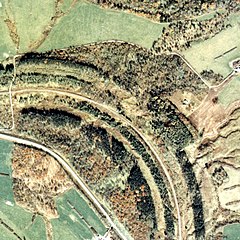
日本語: 網走本線(後の池北線) 釧北信号場/仮乗降場跡 1977年。周囲約1km範囲。左が置戸方面、下が小利別方面。丁度カーブの中間に信号場が設けられた。カーブの外側にうっすらとレール跡状のものが残っているが、この辺りは築堤と路盤跡が広く取られており、複線の構内があった名残がある。その外側の植林された林の辺りに官舎があった。置戸方に青い屋根の保線車両車庫と思われる建家と引込線が見える。 English: Abashiri Main Line (later Ikekita Line) Kushiro Kita Signal Station / Temporary Boarding Station Ruins 1977. The circumference range is about 1 km. On the left is the direction of Okito, and the bottom is the direction of Koribetsu. A signal station was set up just in the middle of the curve. There are still faint rail traces on the outside of the curve, but the embankment and roadbed traces are widely taken around here, and there are remnants of the double track premises. There was a government building around the planted forest outside it. You can see a building and a pull-in line that seems to be a car garage with a blue roof on the side of the door. |
| Date | |
| Source | 国土交通省 国土画像情報(カラー空中写真)を基に作成 |
| Author | Nisanyongo |
| Permission (Reusing this file) |
下記を参照して下さい |
Licensing
[edit]

|
The copyright holder of this file, the Ministry of Land, Infrastructure, Transport and Tourism of Japan, allows anyone to use it for any purpose, provided that the copyright holder is properly attributed. Redistribution, derivative work, commercial use, and all other use is permitted. |
Attribution:
Copyright © National Land Image Information (Color Aerial Photographs), Ministry of Land, Infrastructure, Transport and Tourism
|
 |
This image is copyrighted by the Ministry of Land, Infrastructure, Transport and Tourism of Japan. For terms of use, see the stipulation to use of National Land Information (in Japanese) and message from MLIT (in Japanese and English). When you display this image on an article, include the following phrase in the description: "Made based on National Land Image Information (Color Aerial Photographs), Ministry of Land, Infrastructure, Transport and Tourism".
|
File history
Click on a date/time to view the file as it appeared at that time.
| Date/Time | Thumbnail | Dimensions | User | Comment | |
|---|---|---|---|---|---|
| current | 14:19, 2 September 2013 | | 969 × 969 (873 KB) | Nisanyongo (talk | contribs) | {{Information |Description=網走本線(後の池北線) 釧北信号場/仮乗降場跡 1977年。周囲約1km範囲。左が置戸方面、下が小利別方面。丁度カーブの中間に信号場が設けられた。カーブの外側に... |
You cannot overwrite this file.
File usage on Commons
There are no pages that use this file.
File usage on other wikis
The following other wikis use this file: