File:Sendai Airport after the tsunami.jpg
Jump to navigation
Jump to search

Size of this preview: 800 × 553 pixels. Other resolutions: 320 × 221 pixels | 640 × 442 pixels | 1,024 × 707 pixels | 1,297 × 896 pixels.
Original file (1,297 × 896 pixels, file size: 199 KB, MIME type: image/jpeg)
Captions
Captions
Add a one-line explanation of what this file represents
Summary
[edit]
| Description |
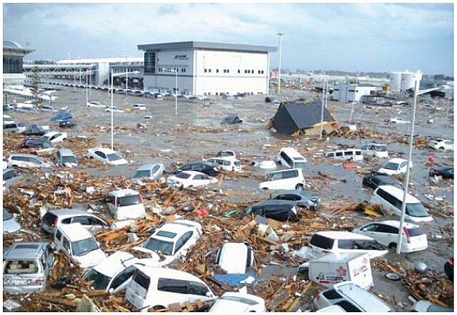
English: Source: Mikio Ishiwatari, Junko Sagara: "Infrastructure Rehabilitation", In: Federica Ranghieri, Mikio Ishiwatari(editors): "Learning from Megadisasters - Lessons from the Great East Japan Earthquake", World Bank Publications, Washington, DC, 2014, Chapter 20, ISBN (paper): 978-1-4648-0153-2, ISBN (electronic): 978-1-4648-0154-9, DOI: 10.1596/978-1-4648-0153-2, pp. 171-179, here: p. 173, Map 20.2: "Sendai Airport after the tsunami" ("Source: MLIT"), License: Creative Commons Attribution CC BY 3.0 IGO.
Description from the mentioned source (p. 173): "The Sendai Airport, the major airport in the Tohoku region, is located about 1 km from the Pacifi ccoast at an elevation of 4 meters above sea level. The tsunami hit the airport and flooded the runway, the first floor of the terminal building, and the airport access railways (figure 20.2)." |
| Date | |
| Source | Mikio Ishiwatari, Junko Sagara: "Infrastructure Rehabilitation", In: Federica Ranghieri, Mikio Ishiwatari(editors): "Learning from Megadisasters - Lessons from the Great East Japan Earthquake", World Bank Publications, Washington, DC, 2014, Chapter 20, ISBN (paper): 978-1-4648-0153-2, ISBN (electronic): 978-1-4648-0154-9, DOI: 10.1596/978-1-4648-0153-2, pp. 171-179, here: p. 173, Map 20.2: "Sendai Airport after the tsunami" ("Source: MLIT"), License: Creative Commons Attribution CC BY 3.0 IGO. |
| Author | Ministry of Land, Infrastructure, Transport and Tourism (MLIT) (Japan) |
| Permission (Reusing this file) |
This file is licensed under the Creative Commons Attribution 3.0 IGO license.
|
File history
Click on a date/time to view the file as it appeared at that time.
| Date/Time | Thumbnail | Dimensions | User | Comment | |
|---|---|---|---|---|---|
| current | 11:32, 6 July 2018 | | 1,297 × 896 (199 KB) | Anglo-Araneophilus~commonswiki (talk | contribs) | {{Information |description ={{en|1=Source: Mikio Ishiwatari, Junko Sagara: "Infrastructure Rehabilitation", In: Federica Ranghieri, Mikio Ishiwatari(editors): "Learning from Megadisasters - Lessons from the Great East Japan Earthquake", World Bank Publications, Washington, DC, 2014, Chapter 20, ISBN (paper): 978-1-4648-0153-2, ISBN (electronic): 978-1-4648-0154-9, DOI: 10.1596/978-1-4648-0153-2, pp. 171-179, here: p. 173, Map 20.2: "Sendai Airport after the tsunami" ("Source: MLIT"), Licens... |
You cannot overwrite this file.
File usage on Commons
The following page uses this file:
File usage on other wikis
The following other wikis use this file:
- Usage on cs.wikipedia.org
- Usage on de.wikipedia.org
- Usage on ja.wikipedia.org