File:Sektarische opdeling van Bagdad nov 2007 bedoelde versie.PNG
Jump to navigation
Jump to search

Size of this preview: 754 × 600 pixels. Other resolutions: 302 × 240 pixels | 604 × 480 pixels | 966 × 768 pixels | 1,115 × 887 pixels.
Original file (1,115 × 887 pixels, file size: 49 KB, MIME type: image/png)
Captions
Captions
Add a one-line explanation of what this file represents
| Description |
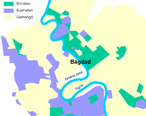
Nederlands: Deze kaart is gebaseerd op wijkgegevens zoals die in het NRC-Handelsblad dd 8-12-2007 verscheen. De ondergrond is blind gedigitaliseerd op gegevens zoals die op openstreetsmap te vinden zijn. De kaart geeft de 'sektarische opdeling' weer van (een deel van) Bagdad (november 2007). De wijken zijn opgedeeld in wijken waar overheersend Sunnitische Moslims wonen, wijken waar overheersend Shi'ieten wonen, en wijken die gemengd zijn. De legenda kleuren aangepast op de wijze zoals die waarschijnlijk is bedoeld; deze kleur verdeling / legenda is waarschijnlijk de juiste, i.t.t. die van het origineel zoals door het NRC gepubliceerd |
| Date | 9-12-2007 |
| Source | Eigen media, obv gegevens NRC-H en www.openstreetsmap.com |
| Author | T.Nijeholt at nl.wikibooks |
Licensing
[edit]
T.Nijeholt at nl.wikibooks, the copyright holder of this work, hereby publishes it under the following licenses:

|
Permission is granted to copy, distribute and/or modify this document under the terms of the GNU Free Documentation License, Version 1.2 or any later version published by the Free Software Foundation; with no Invariant Sections, no Front-Cover Texts, and no Back-Cover Texts. A copy of the license is included in the section entitled GNU Free Documentation License. |
| This file is licensed under the Creative Commons Attribution-Share Alike 3.0 Unported license. | ||
| Attribution: T.Nijeholt at nl.wikibooks | ||
| ||
| This licensing tag was added to this file as part of the GFDL licensing update. |
This file is licensed under the Creative Commons Attribution-Share Alike 2.5 Generic license.
Attribution: T.Nijeholt at nl.wikibooks
- You are free:
- to share – to copy, distribute and transmit the work
- to remix – to adapt the work
- Under the following conditions:
- attribution – You must give appropriate credit, provide a link to the license, and indicate if changes were made. You may do so in any reasonable manner, but not in any way that suggests the licensor endorses you or your use.
- share alike – If you remix, transform, or build upon the material, you must distribute your contributions under the same or compatible license as the original.
You may select the license of your choice.
Original upload log
[edit]
The original description page was here. All following user names refer to nl.wikibooks.
- 2007-12-11 20:09 Nijeholt 1115×887× (50136 bytes) {{Information |Description=Deze kaart is gebaseerd op wijkgegevens zoals die in het NRC-Handelsblad dd 8-12-2007 verscheen. De ondergrond is blind gedigitaliseerd op gegevens zoals die op openstreetsmap te vinden zijn. De kaart geeft de 'sektarische opdel
File history
Click on a date/time to view the file as it appeared at that time.
| Date/Time | Thumbnail | Dimensions | User | Comment | |
|---|---|---|---|---|---|
| current | 17:57, 25 February 2009 | | 1,115 × 887 (49 KB) | BotMultichill (talk | contribs) | {{BotMoveToCommons|nl.wikibooks|year={{subst:CURRENTYEAR}}|month={{subst:CURRENTMONTHNAME}}|day={{subst:CURRENTDAY}}}} {{Information |Description={{nl|Deze kaart is gebaseerd op wijkgegevens zoals die in het NRC-Handelsblad dd 8-12-2007 verscheen. De on |
You cannot overwrite this file.
File usage on Commons
There are no pages that use this file.