File:Sediment Transforms Lake Michigan (5345941823).jpg
Original file (1,956 × 1,790 pixels, file size: 306 KB, MIME type: image/jpeg)
Captions
Captions
Summary
[edit].jpg&action=edit§ion=1)
| Description |
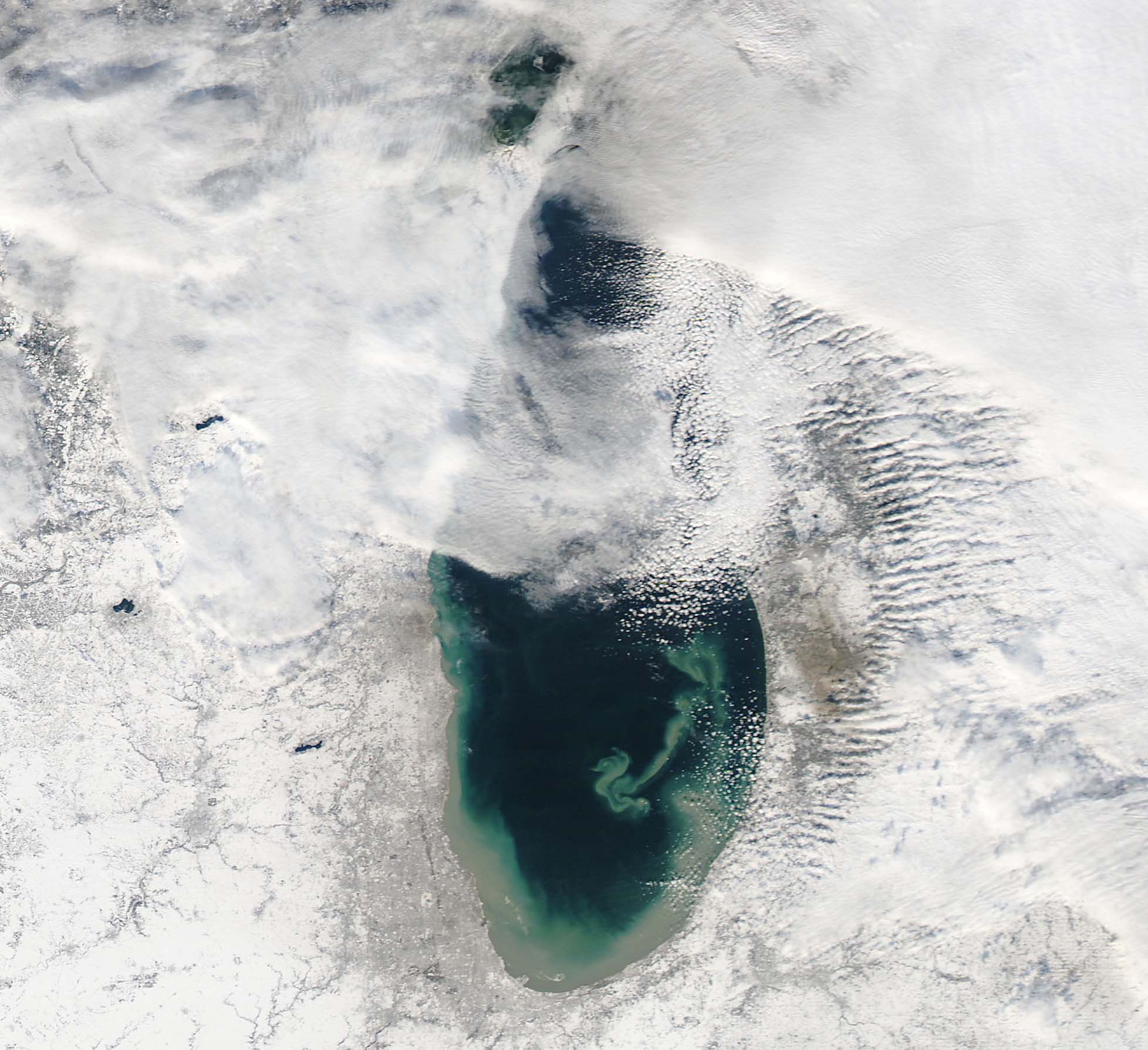
NASA image acquired December 17, 2010 In mid-December 2010, suspended sediments transformed the southern end of Lake Michigan. Ranging in color from brown to green, the sediment filled the surface waters along the southern coastline and formed a long, curving tendril extending toward the middle of the lake. The Moderate Resolution Imaging Spectroradiometer (MODIS) on NASA’s Aqua satellite captured these natural-color images on December 17, 2010 (top), and December 10, 2010 (bottom). Such sediment clouds are not uncommon in Lake Michigan, where winds influence lake circulation patterns. A scientificpaper published in 2007 described a model of the circulation, noting that while the suspended particles mostly arise from lake-bottom sediments along the western shoreline, they tend to accumulate on the eastern side. When northerly winds blow, two circulation gyres, rotating in opposite directions, transport sediment along the southern shoreline. As the northerly winds die down, the counterclockwise gyre predominates, and the smaller, clockwise gyre dissipates. Clear water—an apparent remnant of the small clockwise gyre—continues to interrupt the sediment plume. George Leshkevich, a researcher with the U.S. National Oceanic and Atmospheric Administration, explains that the wind-driven gyres erode lacustrine clay (very fine lakebed sediment) on the western shore before transporting it, along with re-suspended lake sediments, to the eastern shore. On the eastern side, the gyre encounters a shoreline bulge that pushes it toward the lake’s central southern basin, where it deposits the sediments. The sediment plume on December 17 followed a windy weather front in the region on December 16. NASA image courtesy MODIS Rapid Response Team at NASA GSFC. Caption by Michon Scott. Instrument: Aqua - MODIS NASA Goddard Space Flight Center enables NASA’s mission through four scientific endeavors: Earth Science, Heliophysics, Solar System Exploration, and Astrophysics. Goddard plays a leading role in NASA’s accomplishments by contributing compelling scientific knowledge to advance the Agency’s mission. Follow us on Twitter Join us on Facebook To read more about this image go to: earthobservatory.nasa.gov/IOTD/view.php?id=48511 |
| Date | |
| Source | Sediment Transforms Lake Michigan |
| Author | NASA Goddard Space Flight Center from Greenbelt, MD, USA |
Licensing
[edit].jpg&action=edit§ion=2)
- You are free:
- to share – to copy, distribute and transmit the work
- to remix – to adapt the work
- Under the following conditions:
- attribution – You must give appropriate credit, provide a link to the license, and indicate if changes were made. You may do so in any reasonable manner, but not in any way that suggests the licensor endorses you or your use.
| This image was originally posted to Flickr by NASA Goddard Photo and Video at https://flickr.com/photos/24662369@N07/5345941823. It was reviewed on 27 September 2017 by FlickreviewR and was confirmed to be licensed under the terms of the cc-by-2.0. |
File history
Click on a date/time to view the file as it appeared at that time.
| Date/Time | Thumbnail | Dimensions | User | Comment | |
|---|---|---|---|---|---|
| current | 05:42, 27 September 2017 | | 1,956 × 1,790 (306 KB) | A1Cafel (talk | contribs) | Transferred from Flickr via Flickr2Commons |
You cannot overwrite this file.
File usage on Commons
The following page uses this file:
.jpg&oldid=728894789)