File:Sediment Swirls in Lake Pontchartrain and the Gulf of Mexico (MODIS 2021-09-26).jpg

Original file (2,417 × 1,965 pixels, file size: 2.07 MB, MIME type: image/jpeg)
Captions
Captions
Summary
[edit].jpg&action=edit§ion=1)
| Description |
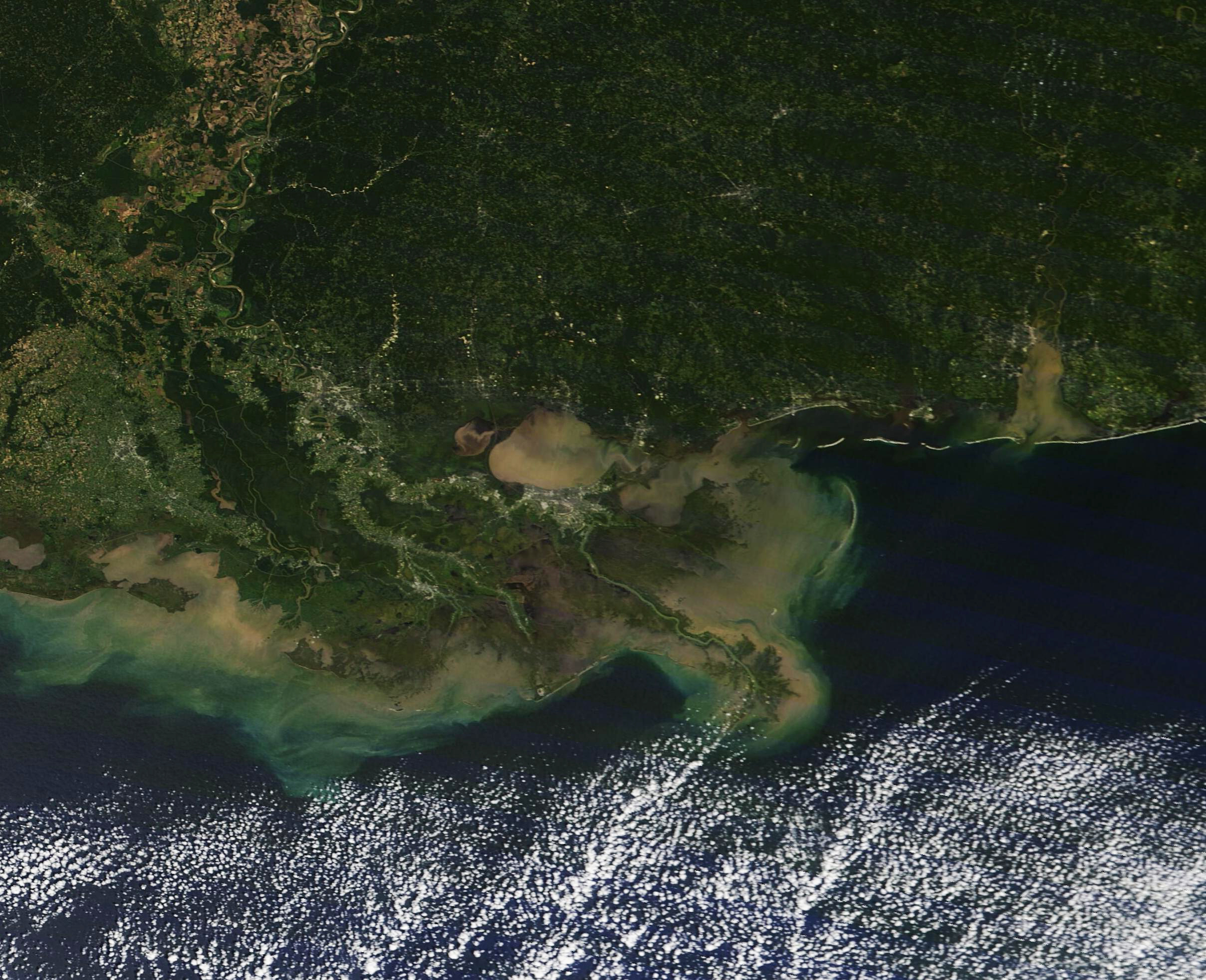
English: Almost a month after Hurricane Ida came ashore as a strong Category 4 hurricane, the storm’s impacts are still visible in southern Louisiana. After a slow approach that churned the waters of the Gulf of Mexico and scoured the shoreline, Ida made landfall on August 29, 2021, carrying maximum sustained winds of 150 mph (240 km/h). The storm brought massive storm surge, torrential rains, and strong winds to coastal Louisiana before it slowly crawled northward on a trek that dumped extreme amounts of rainfall that swept sediment into lakes, rivers, and ultimately the Gulf of Mexico.
While recovery is well underway, significant damage remains, including vast amounts of suspended sediment that is easily seen from space. In addition, the death toll directly attributed to the storm has increased to 26, according to media reports, and thousands remain without power. On September 25, Entergy published on its website that approximately 500 of its customers that are able to safely receive power are waiting for restoration, but several thousands of customers region remain unable to take power. Among these are about 3,700 customers in Lafourche Parish and 3,000 in Jefferson Parish. On September 25, the Moderate Resolution Imaging Spectroradiometer (MODIS) on board NASA’s Terra satellite acquired a true-color image of sediment-stained waters that remain after Hurricane Ida. Just north of the city of New Orleans, Lake Pontchartrain is filled with muddy swirls, as is nearby Lake Maurepas (west) and Lake Borgne (east). Mud-colored tan sediment hugs the entire coastline of Louisiana as well as parts of Mississippi. Further from shore, sediment creates a halo of green as it sinks deeper into the Gulf water. |
||
| Date | Taken on 23 September 2021 | ||
| Source |
Sediment Swirls in Lake Pontchartrain and the Gulf of Mexico (direct link)
|
||
| Author | MODIS Land Rapid Response Team, NASA GSFC |
| This media is a product of the Terra mission Credit and attribution belongs to the mission team, if not already specified in the "author" row |
Licensing
[edit].jpg&action=edit§ion=2)
| This file is in the public domain in the United States because it was solely created by NASA. NASA copyright policy states that "NASA material is not protected by copyright unless noted". (See Template:PD-USGov, NASA copyright policy page or JPL Image Use Policy.) | ||
 |
Warnings:
|
File history
Click on a date/time to view the file as it appeared at that time.
| Date/Time | Thumbnail | Dimensions | User | Comment | |
|---|---|---|---|---|---|
| current | 18:45, 29 January 2024 | | 2,417 × 1,965 (2.07 MB) | OptimusPrimeBot (talk | contribs) | #Spacemedia - Upload of http://modis.gsfc.nasa.gov/gallery/images/image09262021_250m.jpg via Commons:Spacemedia |
You cannot overwrite this file.
File usage on Commons
There are no pages that use this file.
.jpg&oldid=846896755)