File:Sediment-stained Bay of Fundy (MODIS 2024-06-18).jpg
Jump to navigation
Jump to search

Size of this preview: 735 × 600 pixels. Other resolutions: 294 × 240 pixels | 589 × 480 pixels | 942 × 768 pixels | 1,255 × 1,024 pixels | 2,225 × 1,815 pixels.
Original file (2,225 × 1,815 pixels, file size: 326 KB, MIME type: image/jpeg)
Captions
Captions
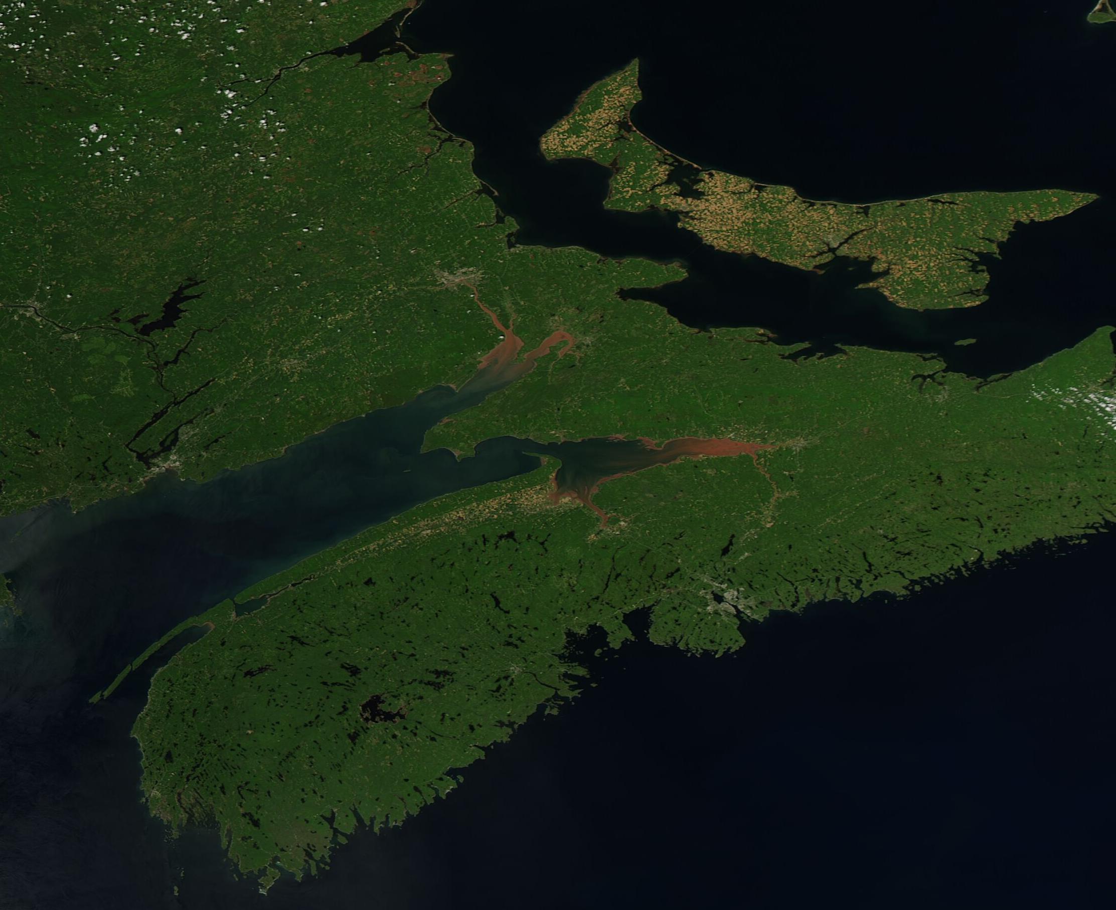
On June 6, 2024, the Moderate Resolution Imaging Spectroradiometer (MODIS) on NASA’s Aqua satellite acquired a true-color image highlighting the spectacular chocolate color waters at the northeastern reach of the Bay of Fundy.
Summary
[edit].jpg&action=edit§ion=1)
| Description |
English: On June 6, 2024, the Moderate Resolution Imaging Spectroradiometer (MODIS) on NASA’s Aqua satellite acquired a true-color image highlighting the spectacular chocolate color waters at the northeastern reach of the Bay of Fundy.
The Bay of Fundy is an inlet of the Atlantic Ocean separating the Canadian provinces of New Brunswick, which lies on the north and west, from Nova Scotia on the south and east side of the Bay. Prince Edward Island, which sits in the Gulf of Saint Lawrence, can also be seen in this image. The uniquely chocolate-colored rivers that flow into the Bay of Fundy pick up sediment far upstream as they pass through soft, red, and easily eroded Triassic-era sandstone of northeastern Canada. In addition, the Bay’s spectacular tidal action—it has the highest tides observed tides anywhere on Earth—stirs the mudflats at the head of the Bay and adds to the sediment-staining. The height of the tide at the long, narrow Minas Basin can reach 16 meters (53 feet). By comparison, most of the coast of the United States has a tidal range of 1-2 meters (3-6 feet). |
||
| Date | Taken on 16 June 2024 | ||
| Source |
Sediment-stained Bay of Fundy (direct link)
|
||
| Author | MODIS Land Rapid Response Team, NASA GSFC |
| This media is a product of the Aqua mission Credit and attribution belongs to the mission team, if not already specified in the "author" row |
Licensing
[edit].jpg&action=edit§ion=2)
| This file is in the public domain in the United States because it was solely created by NASA. NASA copyright policy states that "NASA material is not protected by copyright unless noted". (See Template:PD-USGov, NASA copyright policy page or JPL Image Use Policy.) | ||
 |
Warnings:
|
File history
Click on a date/time to view the file as it appeared at that time.
| Date/Time | Thumbnail | Dimensions | User | Comment | |
|---|---|---|---|---|---|
| current | 05:05, 18 June 2024 | | 2,225 × 1,815 (326 KB) | OptimusPrimeBot (talk | contribs) | #Spacemedia - Upload of http://modis.gsfc.nasa.gov/gallery/images/image06182024_250m.jpg via Commons:Spacemedia |
You cannot overwrite this file.
File usage on Commons
There are no pages that use this file.
.jpg&oldid=909380590)