File:Second World War bunker in Newlands Plantation, New Forest - geograph.org.uk - 312899.jpg
Jump to navigation
Jump to search

Size of this preview: 450 × 600 pixels. Other resolutions: 180 × 240 pixels | 480 × 640 pixels.
Original file (480 × 640 pixels, file size: 159 KB, MIME type: image/jpeg)
Captions
Captions
Add a one-line explanation of what this file represents
Summary
[edit]
| Description |
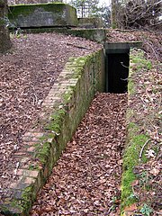
English: Second World War bunker in Newlands Plantation, New Forest Most of the trees surrounding this "battle headquarters" bunker must have been planted after the end of the 1939-45 war - then there would have been a good view of the Ibsley airfield and surroundings from this position on a spur of Ibsley Common. The brick and concrete structure, divided into several rooms, survives well up here - although it contains a small amount of modern-day litter. There are the remains of several small WWII structures up on Ibsley Common.
The following is a short extract from the R.A.F. Ibsley Historical group website ( http://www.rafibsley.co.uk/ ): "The Battle Headquarters at Ibsley was built deep into the hillside of Newlands, off the Moyles Court Gorley Road, behind Keepers Cottage. This is still there today. It has two observation post blocks, which is considered to be unique. It was suggested the reason for this is, probably, that the first was originally intended to cover the old airfield, but when the runway was extended southward to Ivy Lane the field of vision had to be increased, hence the second observation post block." |
| Date | |
| Source | From geograph.org.uk |
| Author | Jim Champion |
| Attribution (required by the license) | Jim Champion / Second World War bunker in Newlands Plantation, New Forest / |
| Camera location | | View this and other nearby images on: OpenStreetMap |
|---|
_heading:45.00&language=en)
| Object location | | View this and other nearby images on: OpenStreetMap |
|---|
_heading:45.00&language=en)
Licensing
[edit]

|
This image was taken from the Geograph project collection. See this photograph's page on the Geograph website for the photographer's contact details. The copyright on this image is owned by Jim Champion and is licensed for reuse under the Creative Commons Attribution-ShareAlike 2.0 license.
|
This file is licensed under the Creative Commons Attribution-Share Alike 2.0 Generic license.
Attribution: Jim Champion
- You are free:
- to share – to copy, distribute and transmit the work
- to remix – to adapt the work
- Under the following conditions:
- attribution – You must give appropriate credit, provide a link to the license, and indicate if changes were made. You may do so in any reasonable manner, but not in any way that suggests the licensor endorses you or your use.
- share alike – If you remix, transform, or build upon the material, you must distribute your contributions under the same or compatible license as the original.
File history
Click on a date/time to view the file as it appeared at that time.
| Date/Time | Thumbnail | Dimensions | User | Comment | |
|---|---|---|---|---|---|
| current | 15:39, 30 December 2010 | | 480 × 640 (159 KB) | GeographBot (talk | contribs) | == {{int:filedesc}} == {{Information |description={{en|1=Second World War bunker in Newlands Plantation, New Forest Most of the trees surrounding this "battle headquarters" bunker must have been planted after the end of the 1939-45 war - then there would |
You cannot overwrite this file.
File usage on Commons
There are no pages that use this file.