File:Sea defences - geograph.org.uk - 775461.jpg
Jump to navigation
Jump to search
No higher resolution available.
Sea_defences_-_geograph.org.uk_-_775461.jpg (640 × 480 pixels, file size: 80 KB, MIME type: image/jpeg)
Captions
Captions
Add a one-line explanation of what this file represents
Summary
[edit]
| Description |
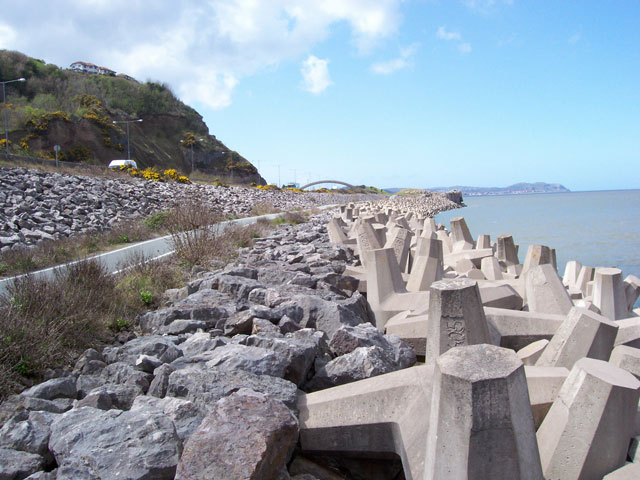
English: Sea defences The route of the A55 'Col-Con' Expressway was severely constrained by the coastal topography and built environment. Here the road passes through the site of a large coastal quarry and considerable engineering was required to create and defend the new formation. Cast-concrete anchor blocks interlock to provide a primary energy-dispersive barrier, with conventional rock-armour to stabilise the upper slope. Very geometric, but very dangerous because the structure includes large voids into which anything can drop easily. |
| Date | |
| Source | From geograph.org.uk |
| Author | Jonathan Wilkins |
| Attribution (required by the license) | Jonathan Wilkins / Sea defences / |
| Camera location | | View this and other nearby images on: OpenStreetMap |
|---|
_heading:292.00&language=en)
| Object location | | View this and other nearby images on: OpenStreetMap |
|---|
_heading:292.00&language=en)
Licensing
[edit]

|
This image was taken from the Geograph project collection. See this photograph's page on the Geograph website for the photographer's contact details. The copyright on this image is owned by Jonathan Wilkins and is licensed for reuse under the Creative Commons Attribution-ShareAlike 2.0 license.
|
This file is licensed under the Creative Commons Attribution-Share Alike 2.0 Generic license.
Attribution: Jonathan Wilkins
- You are free:
- to share – to copy, distribute and transmit the work
- to remix – to adapt the work
- Under the following conditions:
- attribution – You must give appropriate credit, provide a link to the license, and indicate if changes were made. You may do so in any reasonable manner, but not in any way that suggests the licensor endorses you or your use.
- share alike – If you remix, transform, or build upon the material, you must distribute your contributions under the same or compatible license as the original.
File history
Click on a date/time to view the file as it appeared at that time.
| Date/Time | Thumbnail | Dimensions | User | Comment | |
|---|---|---|---|---|---|
| current | 22:57, 19 February 2011 | | 640 × 480 (80 KB) | GeographBot (talk | contribs) | == {{int:filedesc}} == {{Information |description={{en|1=Sea defences The route of the A55 'Col-Con' Expressway was severely constrained by the coastal topography and built environment. Here the road passes through the site of a large coastal quarry and c |
You cannot overwrite this file.
File usage on Commons
There are no pages that use this file.
File usage on other wikis
The following other wikis use this file:
- Usage on de.wikipedia.org
- Usage on en.wikipedia.org
- Usage on fa.wikipedia.org
- Usage on id.wikipedia.org