File:Scotstoun West railway station (site), Glasgow (geograph 6070271).jpg
Jump to navigation
Jump to search

Size of this preview: 800 × 600 pixels. Other resolutions: 320 × 240 pixels | 640 × 480 pixels | 1,024 × 768 pixels | 1,280 × 960 pixels | 1,600 × 1,200 pixels.
Original file (1,600 × 1,200 pixels, file size: 881 KB, MIME type: image/jpeg)
Captions
Captions
Add a one-line explanation of what this file represents
Summary
[edit],_Glasgow_(geograph_6070271).jpg&action=edit§ion=1)
| Description |
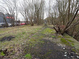
English: Scotstoun West railway station (site), Glasgow Opened in 1896 as "Scotstoun" by the Lanarkshire and Dumbartonshire Railway, part of the Caledonian Railway, on the line from Partick to Dumbarton. The name was changed to Scotstoun West in 1900. The station closed in 1964. View north west towards Yoker Ferry and Dumbarton. Both the platform on the viaduct and the former entrance down below at street level were both extant when this image was taken. A bridleway is adjacent to the station site. |
| Date | |
| Source | From geograph.org.uk |
| Author | Nigel Thompson |
| Permission (Reusing this file) |
Creative Commons Attribution Share-alike license 2.0 |
| Attribution (required by the license) | Nigel Thompson / Scotstoun West railway station (site), Glasgow / |
| Camera location | | View this and other nearby images on: OpenStreetMap |
|---|
,_Glasgow_(geograph_6070271).jpg¶ms=055.881792_N_-004.363398_E_globe:Earth_type:camera_source:geograph-osgb36(NS52266793)_heading:292.00&language=en)
| Object location | | View this and other nearby images on: OpenStreetMap |
|---|
,_Glasgow_(geograph_6070271).jpg¶ms=055.881870_N_-004.364040_E_globe:Earth_class:object_type:object_source:geograph-osgb36(NS52226794)_heading:292.00&language=en)
Licensing
[edit],_Glasgow_(geograph_6070271).jpg&action=edit§ion=2)

|
This image was taken from the Geograph project collection. See this photograph's page on the Geograph website for the photographer's contact details. The copyright on this image is owned by Nigel Thompson and is licensed for reuse under the Creative Commons Attribution-ShareAlike 2.0 license.
|
This file is licensed under the Creative Commons Attribution-Share Alike 2.0 Generic license.
Attribution: Nigel Thompson
- You are free:
- to share – to copy, distribute and transmit the work
- to remix – to adapt the work
- Under the following conditions:
- attribution – You must give appropriate credit, provide a link to the license, and indicate if changes were made. You may do so in any reasonable manner, but not in any way that suggests the licensor endorses you or your use.
- share alike – If you remix, transform, or build upon the material, you must distribute your contributions under the same or compatible license as the original.
File history
Click on a date/time to view the file as it appeared at that time.
| Date/Time | Thumbnail | Dimensions | User | Comment | |
|---|---|---|---|---|---|
| current | 23:00, 4 January 2020 | | 1,600 × 1,200 (881 KB) | Lamberhurst (talk | contribs) | Transferred from geograph.co.uk using [https://tools.wmflabs.org/geograph2commons/ geograph2commons] |
You cannot overwrite this file.
File usage on Commons
The following page uses this file:
,_Glasgow_(geograph_6070271).jpg&oldid=616402743)