File:Scopus umbretta -Kruger National Park, South Africa-8a.jpg
Original file (2,757 × 2,018 pixels, file size: 1.28 MB, MIME type: image/jpeg)
Captions
Summary
[edit]DescriptionScopus umbretta -Kruger National Park, South Africa-8a.jpg |
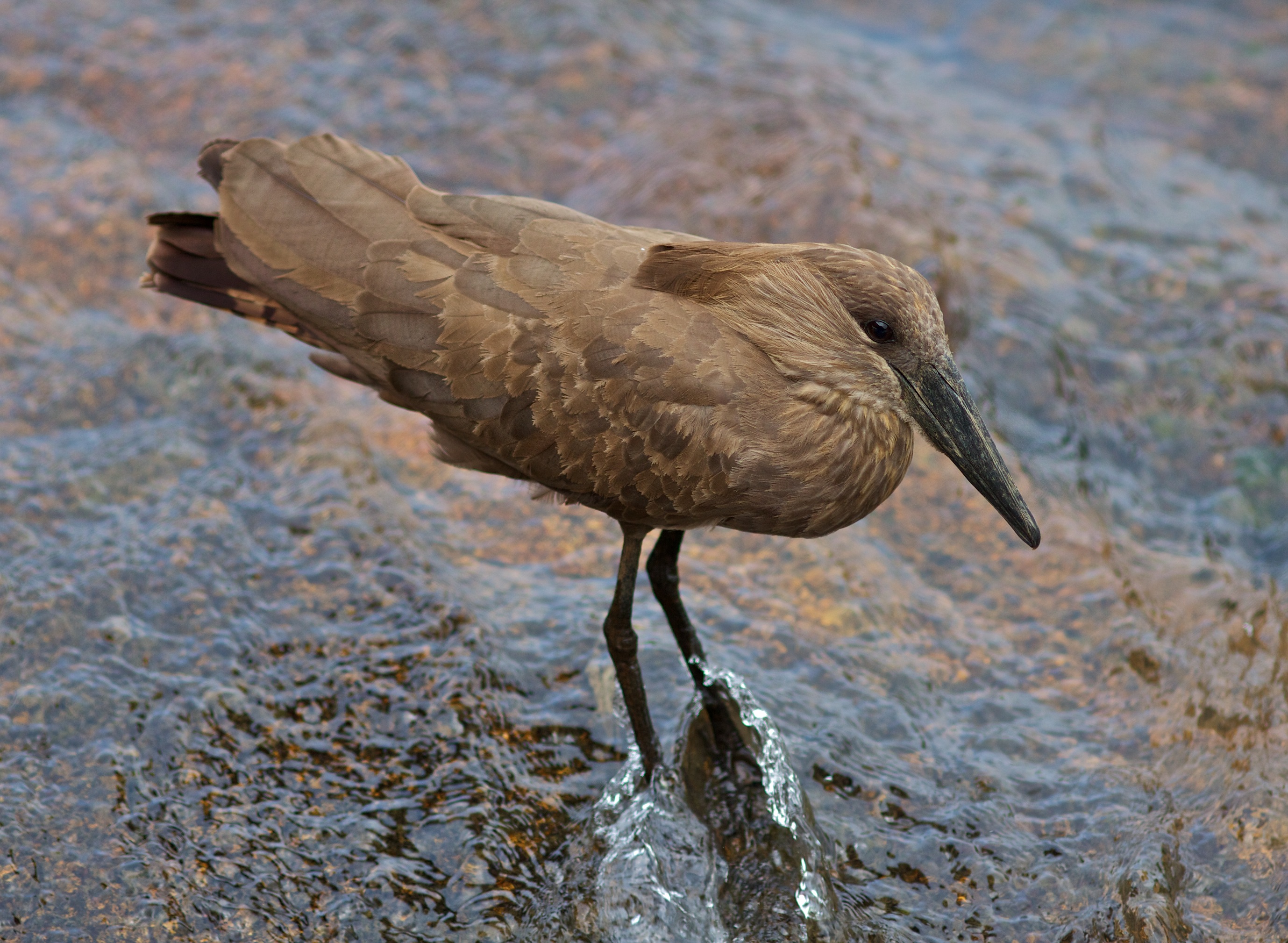
Afrikaans: 'n Hamerkop bespied vlak water naby die Sabie-Sandrivier-samevloeiing in die suidelike Krugerwildtuin. Die aanwesigheid van donker, nuwe sowel as verblykte, verweerde vlerkvere dui op ververing.
English: A Hamerkop foraging at springtime near the Sabie-Sand River confluence in the southern Kruger National Park, South Africa. Wing moult is evident from the mix of dark new and bleached abraded feathers. |
Date | |
Source |
|
Author | hyper7pro from Secunda, South Africa |
Camera location | 24° 58′ 35.56″ S, 31° 37′ 28.01″ E | View this and other nearby images on: OpenStreetMap | -24.976544; 31.624447 |
---|
Licensing
[edit]- You are free:
- to share – to copy, distribute and transmit the work
- to remix – to adapt the work
- Under the following conditions:
- attribution – You must give appropriate credit, provide a link to the license, and indicate if changes were made. You may do so in any reasonable manner, but not in any way that suggests the licensor endorses you or your use.
This image, originally posted to Flickr, was reviewed on October 29, 2011 by the administrator or reviewer File Upload Bot (Magnus Manske), who confirmed that it was available on Flickr under the stated license on that date. |
This image has been assessed using the Quality image guidelines and is considered a Quality image.
العربية ∙ جازايرية ∙ беларуская ∙ беларуская (тарашкевіца) ∙ български ∙ বাংলা ∙ català ∙ čeština ∙ Cymraeg ∙ Deutsch ∙ Schweizer Hochdeutsch ∙ Zazaki ∙ Ελληνικά ∙ English ∙ Esperanto ∙ español ∙ eesti ∙ euskara ∙ فارسی ∙ suomi ∙ français ∙ galego ∙ עברית ∙ हिन्दी ∙ hrvatski ∙ magyar ∙ հայերեն ∙ Bahasa Indonesia ∙ italiano ∙ 日本語 ∙ Jawa ∙ ქართული ∙ 한국어 ∙ kurdî ∙ Lëtzebuergesch ∙ lietuvių ∙ македонски ∙ മലയാളം ∙ मराठी ∙ Bahasa Melayu ∙ Nederlands ∙ Norfuk / Pitkern ∙ polski ∙ português ∙ português do Brasil ∙ rumantsch ∙ română ∙ русский ∙ sicilianu ∙ slovenčina ∙ slovenščina ∙ shqip ∙ српски / srpski ∙ svenska ∙ தமிழ் ∙ తెలుగు ∙ ไทย ∙ Tagalog ∙ Türkçe ∙ toki pona ∙ українська ∙ vèneto ∙ Tiếng Việt ∙ 中文 ∙ 中文(简体) ∙ 中文(繁體) ∙ +/− |
File history
Click on a date/time to view the file as it appeared at that time.
Date/Time | Thumbnail | Dimensions | User | Comment | |
---|---|---|---|---|---|
current | 21:29, 29 October 2011 | 2,757 × 2,018 (1.28 MB) | File Upload Bot (Magnus Manske) (talk | contribs) | {{Information |Description=Hamerkop |Source=[http://www.flickr.com/photos/hyper7/6291256578/ Hamerkop] * Uploaded by snowmanradio |Date=2011-10-25 11:12 |Author=[http://www.flickr.com/people/7997249@N06 hyper7pro] from Secunda, South |
You cannot overwrite this file.
File usage on Commons
The following 5 pages use this file:
File usage on other wikis
The following other wikis use this file:
- Usage on af.wikipedia.org
Metadata
This file contains additional information such as Exif metadata which may have been added by the digital camera, scanner, or software program used to create or digitize it. If the file has been modified from its original state, some details such as the timestamp may not fully reflect those of the original file. The timestamp is only as accurate as the clock in the camera, and it may be completely wrong.
Camera manufacturer | Canon |
---|---|
Camera model | Canon EOS 60D |
Author | Johann Snyman |
Exposure time | 1/1,250 sec (0.0008) |
F-number | f/2.8 |
ISO speed rating | 200 |
Date and time of data generation | 11:12, 25 October 2011 |
Lens focal length | 200 mm |
Latitude | 24° 58′ 35.4″ S |
Longitude | 31° 37′ 28.2″ E |
Altitude | 275.56 meters above sea level |
Orientation | Normal |
Horizontal resolution | 72 dpi |
Vertical resolution | 72 dpi |
Software used | Aperture 3.1.3 |
File change date and time | 11:12, 25 October 2011 |
Exposure Program | Action program (biased toward fast shutter speed) |
Exif version | 2.3 |
Date and time of digitizing | 11:12, 25 October 2011 |
APEX shutter speed | 10.375 |
APEX aperture | 3 |
APEX exposure bias | 0 |
Maximum land aperture | 2.8284272497897 APEX (f/2.67) |
Metering mode | Pattern |
Flash | Flash did not fire, compulsory flash suppression |
DateTime subseconds | 00 |
DateTimeOriginal subseconds | 00 |
DateTimeDigitized subseconds | 00 |
Supported Flashpix version | 1 |
Color space | sRGB |
Focal plane X resolution | 5,728.1764705882 |
Focal plane Y resolution | 5,808.4035087719 |
Focal plane resolution unit | inches |
Custom image processing | Normal process |
Exposure mode | Auto exposure |
White balance | Auto white balance |
Scene capture type | Standard |
Geodetic survey data used | WGS-84 |
GPS tag version | 2.2.0.0 |
IIM version | 2 |
Structured data
Items portrayed in this file
depicts
25 October 2011
24°58'35.558"S, 31°37'28.009"E
0.0008 second
2.8
200 millimetre
200
- Files with coordinates missing SDC location of creation
- CC-BY-2.0
- Flickr images reviewed by File Upload Bot (Magnus Manske)
- Flickr images missing SDC creator
- Quality images of birds in South Africa
- Quality images of Scopus umbretta
- Quality images
- Quality images missing SDC depicts
- Quality images missing SDC creator
- South Africa photographs taken on 2011-10-25
- Quality images of Kruger National Park
- Pages with maps